Semantic search

|
[[First Responders on the Grid]] | |
| Leverage a platform that allows for alerting drivers when first responders are in route nearby. The platform will use existing mobile networks within the city to send the alerts to drivers on their phones and in-dash through our partnerships with automotive companies. The project will assist in moving drivers out of the way of first responders which will ultimately reduce response times, reduce the number of vehicles driving towards an active scene, and look at learnings from analytics and metrics for how long first responders were in lights and sirens mode. | ||
|
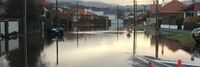
[[Flood Abatement]] | |
Predict Flooding & provide safety to human life, Current Project in Dunedin, NZ
| ||
|
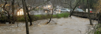
[[Flood Judge]] | |
| Combining low cost / commodity sensors, enterprise IT skillsets, existing / familiar tools with the power of the cloud and artificial intelligence to proactively monitor and alert water levels in creeks during storm activity. | ||

|
[[Framework for Enhancing Disaster Mitigation and Regeneration of Community Capacity]] | |
| Establishment of a framework that fosters collaborative efforts between diverse public, private, and academic partners to enhance disaster mitigation, community resilience and economic growth. | ||

|
[[Full functioned Autonomous driving development park in Taiwan]] | |
Key Deliverables
| ||
|
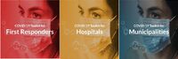
[[GCTC CPAC COVID-19 eResourceKit]] | |
| This eResouceKit is your guide to Working, Learning, and Living from Home, with your security and privacy defended. It will be a long and challenging road for us all, but we can and will get there, together by taking informed actions to gain control and risk prioritization during and after the pandemic - Cities and Communities, Businesses, First Responders, and Self-Employed/Gig Workers | ||

|
[[GCTC Connectivity Covid-19 Resources]] | |
| The Covid-19 crisis has increased the need for students to distance learn and workers to telework; however, the digital divide remains as an unbridged connectivity and device gap for many. Devices such as mobile devices, notebook computers must be in place or issued that can connect wirelessly to Wi-Fi for distance learning and teleworking. Some local governments and companies have made progress through publishing online and through physical postings to map these sites. Other local governments may be further ahead in advanced connectivity having deployed wireless connectivity delivery systems that can easily scale to more locations such as parked vehicles with Wi-Fi equipment. | ||
|
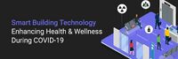
[[GCTC SBSC Covid-19 Resources]] | |
| The Smart Buildings Supercluster (SBSC) convenes public, private, and academic organizations to collaborate in the development and interrelationship of smart buildings within the smart city context.
This Covid-19 Resources page includes links to funding resources, contact tracing application testing being done in India, and two frameworks of how to approach post pandemic recovery.
| ||

|
[[GEO Fencing Predictive Policing solutions to reduce response times for first responders]] | |
| Designed to reduce domestic violent and recidivism crimes and provide evidence for courts using GEO fencing technology with our patented Predictive Policing Network with an intelligent tiered alerting system and hardware tracking devices with sensors implemented with fail safes in order to provide simultaneous alerts to victims, police and dispatch centers for a means to intervene with a crime and document substantial evidence to enforce orders. After testing the prototype we believe the tool can become a solution for various first responder needs to improve the safety and quality of life for our communities. | ||
|
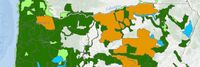
[[GIS Resources from the Oregon Department of Forestry]] | |
| Oregon Department of Forestry's GIS Data is maintained by the Information Technology Department's GIS Unit. | ||
|
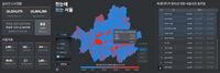
[[GO-PS Gyeonggi Open Platform for SmartCity]] | |
| GO⋅PS is a smart city standard platform to utilize the element technology of the age of 4th Industrial Revolution as a means to solve urban problems.
The Gyeonggi Province of Korea, along with Gyeonggi Research Institute (GRI) and Gyeonggido Business and Science Accelerator (GBSA), is currently creating and operating an industry-academia-related consultative body to create a sustainable business model. GO⋅PS matches companies, research institutes, and academics according to the demand of public urban matters, and uses its technologies, research works, and consulting methods to create solutions for problems and have them collected on the platform. The GO・PS is currently comprised of three large departments namely, Smart Transport, Smart Energy, and Smart Healthcare. (It is planned to be expanded with more departments in the future) | ||
|
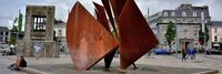
[[Galway Smart City]] | |
| Galway has pioneered some smart city ideas. It has implemented an award winning 3 bin recycling scheme that achieved higher levels of recycling than any before seen in Ireland. Galway was the first city in Ireland to achieve the European Energy Award. It is involved in a number of projects to reduce energy usage and to lower the levels of carbon emissions. It adopted a smarter travel policy, including a new public transport strategy, various schemes to encourage citizen’s mobility (cycling and walking) and improved traffic management systems. The ‘slow the flow’ programme reduced the amount of drinking water being wasted in the City. In terms of education, Galway was possibly the first City in the world to achieve Green Flag status in all of its schools.
Galway Smart City - Light Pollution This project ensure the design of external lighting that minimizes the incidence of light pollution, glare and spillage into the surrounding environment and has due regard to the visual and residential amenities of surrounding areas. Galway Smart City - Air Quality and Noise This project aims for maintaining air quality to a satisfactory standard by regulating and monitoring atmospheric emissions in accordance with EU directives on air quality, by promoting and supporting initiatives to reduce air pollution, by increasing the use of public transport, developing urban woodland, encouraging tree planting and conserving green open space. | ||

|
[[Global Applications, Projects and Resources]] | |
| There are applications being created globally to track citizens that may have COVID-19 or have been exposed to someone who is, perform surveillance, carry out tests for symptoms, etc.. These applications may have Privacy and Security risks and vulnerabilities. | ||
|
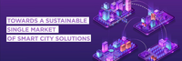
[[Global Digital Single Market for Smart Cities FIWARE]] | |
| The project will demonstrate the potential impact of creating a digital single market for smart cities based on the adoption of a minimum common set of de-facto platform standards enabling solutions to interoperate within, and be replicable across, multiple cities. | ||

|
[[Global High Impact Energy Efficiency]] | |
Objectives:
| ||

|
[[Global Organization of Smart Cities GO SMART]] | |
* Currently many cities in the world are facing similar challenges and have therefore developed their own Smart City strategy and are running their own Smart City projects. Considering the similarity of the challenges, there lies huge potential in effective knowledge exchange and collaboration.
| ||
|
[[Go-Green]] | |
| GoGreen aims to help people understand the impact of small sustainable gestures on their communities through technology. It presents itself as a community rewards system where participating points providers can define actions that support their communities objectives and reward people for taking them. For the users they see a marketplace of options along with rewards based on secure blockchain based smart contracts for supportive behavior. | ||

|
[[Green Horizons: Urban Workforce Development and Electrification Center]] | |
| The Green Horizons Workforce Development and Vehicle Electrification Center is pursuing a
planning grant that aims to establish a positive sustainable economic impact for the Multnomah County Drainage District community. This project will produce an assessment plan for a combined workforce training and commercial grade EV fleet conversion facility. | ||

|
[[Guidance and Resources for Connectivity]] | |
| This page is the list of available guidances and resources for connectivity during pandemic. | ||

|
[[Guidance on Safe and Secure return to work]] | |
| Companies preparing for the easing of coronavirus lockdowns face new and unprecedented challenges as they prepare for opening up offices. Employers and employees should follow guidance from the Centers for Disease Control and Prevention (CDC) as well as state/local public health authorities on how best to slow the spread of this disease and protect workers, customers, clients, and the general public. | ||

|
[[Guidelines for Individuals and Communities in Confinement amid COVID-19]] | |
| A Pandemic declaration, in terms of the World Health Organisation (WHO), involves two main criteria, first the propagation of a disease in more than one continent and secondly the number of identified cases that are not imported but result from local transmission. In a pandemic, if the virus is known, it is expected that there would be procedures in place that are part of existing health protocol(s) for specific areas. Those procedures are studied and defined based on their impact on society and the number of identified cases. | ||

|
[[Gyeonggi Provincial virtual power plant in Gyeonggi Open Platform for Smart city]] | |
This is a project concept which is to create citizen-led, decentralized, local energy-based society that builds foundations on which the distributed resources (ESS, solar power) in the region that can proliferate profitable models which citizens invest, own, trade and operate.
| ||

|
[[Hello Lamp Post UBC Campus]] | |
| Initially launched as a pilot project, Hello UBC was designed to innovatively engage students and staff on campus, to support the parking and access services team. Their goal was to communicate key messages and gain insights into the behaviours of commuters and visitors around campus. | ||

|
[[Helping low-cost or free internet connectivity]] | |
| Programs and organizations helping to identify and provide low-cost or free broadband connectivity. | ||

|
[[Home Automation]] | |
| Step by step process of automating a home using various technologies. | ||

|
[[Homma Haus Mount Tabor]] | |
| Homma Haus Mount Tabor is a multi-family community project, integrating the best in technology with modern architecture. This is just the beginning of HOMMA creating homes built ready for today’s lifestyle. The living spaces allow you to connect with nature, achieve mindfulness, and recharge in comfort – the essentials of a healthy life. | ||

|
[[Homma Haus Waterside]] | |
| Homma Haus Waterside is a residential home design, integrating the best in technology with modern architecture. This is just the beginning of creating homes built ready for today’s lifestyle. Our living spaces will allow you to connect with nature, achieve mindfulness, and recharge in comfort – the essentials of a healthy life. | ||

|
[[I3 Consortium Action Cluster]] | |
| The I3 project is creating a tool that will allow independent device owners to directly manage how the data streams from their IOT devices are delivered to applications. Opensource Project software includes support for privacy, trust, and incentive management.
Requirements and proof-of-concepts complete. Consortium management structure in process. Demonstration systems in process. R1.0 beta software in design. | ||

|
[[Illuminating Smart Cities: Kansas City Runs on IoT Platform]] | |
| Kansas City, MO (KCMO) and its partners have designed and implemented an IoT platform to develop a smart city network, starting with Kansas City’s streetcar starter line in their Downtown area. Based on this initial site, the team has will implement a model that would make Kansas City the largest smart city network in North America. | ||

|
[[India Stack]] | |
| India Stack is the moniker for a set of open APIs and digital public goods that aim to unlock the economic primitives of identity, data, and payments at population scale. | ||

|
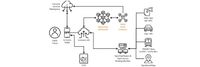
[[Indoor GPS-denied First Responder Location and Tracking Solutions]] | |
| First Responder personnel often work indoors, underground, and in other areas without accurate GPS. Determining the location of public safety personnel working in areas without a clear view of the sky, and therefore without access to reliable GPS, and providing mechanisms to create, access and share map (building and asset) data, is the focus of this project. The objectives are to accelerate availability of improved location accuracy, comprehensive map data sources and tools, and 3D visualization to meet an array of first responder use cases. | ||

|
[[Information Resource Toolkit for Business]] | |
| Tools and resources with guidance for businesses during the epidemic. | ||

|
[[Information Resource Toolkit for Cities and Communities]] | |
| Collection of useful information for cities and communities. | ||

|
[[Information Resource Toolkit for First Responders]] | |
| Tools and resources for First Responders guidance during the epidemic. | ||

|
[[Information for First Responders on Maintaining Operational Capabilities During a Pandemic]] | |
| First responders have a critical role in pre-hospital emergency care and must continue to provide this essential service and fill the many emergency response roles in a community. | ||

|
[[Integrated Analytics and Scheduling of Emergency Responders Under Uncertainty]] | |
| This project will use historical data to create models for various safety and emergency incidents across metropolitan Nashville, establish causes, and use this information to identify appropriate equipment requirements in different situations. This analysis will be combined with historical traffic and delay information to ensure the emergency vehicles are distributed at optimal locations and proactively maintained. During an incident a real-time decision support system will guide vehicle dispatch. | ||

|
[[Integrated Vehicle Service System]] | |
| The main purpose of the project is to expand the Smart Car project to next step - Smart Car system II that will enable citizens all kind of vehicle services, integrated into one system. The main target of this project is to guarantee advanced technologies and increase the type, accessibility and quality of the vehicle related public and private sector services from one point, online. | ||
|
[[Intelligent Transportation System applications in Kaohsiung City]] | |
| Create an intelligent traffic monitoring system connected to real-time Traffic Information System to reduce traffic congestion and raise the road safety in the city. Including telecom big data analysis for plan of traffic improvement strategy, congestion prediction and alert, intelligent parking guidance and Cooperative Vehicle-Infrastructure System for intersection safety. | ||

|
[[IoT Device Security for Smart Cities]] | |
Objectives
| ||
|
|
[[IoT Enabled Smart City Workshop]] | |
| Create tutorials, workshop and practice use cases for smart cities.
Demonstrate smart city applications as per NIST framework (work in progress). The workshop also discusses about IoT standards and protocol which would help ; community partners and city/municipality staff to get familiar with national as well as international IoT standards. Demonstrate how the vulnerability and external threats affect Cybersecurity and privacy. Build a model for the city and municipality leaders to visualize and take corrective steps. Build prototypes as per municipalities requirement and scale for other cities. Utilize NSF funded Maker’s space at Sonoma State University. The Lab is open for all cities/municipalities to build their proto types. The Lab has facilities to build product from scratch. (paper concept to proto type) | ||
|
[[IoT and AI based Smart Energy Management System for Smart City]] | |
| IoT & AI based Smart Energy Management Platform was deployed in public buildings in Suwon City to provide optimal management building facilities, environment, and energy using the urban 3D map and 3D spatial modeling. With the M&V (Measurement & Verification) engine using a standard algorithm, IPMVP (International Performance Measurement and Verification Protocol) as well as data intelligence technology with deep-learning, the platform can quickly measure energy performance and determine energy efficiency. | ||

|
[[IoT based waste management system-Smart Garbage Monitoring System]] | |
| Smart Garbage Monitoring System (SGMS) is a real time indicator of the level of trash at any given time. SGMS Optimize waste collection routes and ultimately reduce fuel consumption. It allows trash collectors to plan their daily/weekly pick up schedule. SGMS is to detect garbage level in Garbage Can. A unique identification number ( ID) is given to each can. As soon as the Garbage Can is full/ over flowing then a SMS is sent to the server from where all the garbage collection vehicles are allotted. | ||
|
|
[[IoT for Mitigation - Telemedicine]] | |

|
[[IoT-based Smart Energy Management System for Smart Green City]] | |
The purpose of this research is to develop the convergence technologies of IoT-based smart energy management system that can minimize building energy use and utility bills. To accomplish the goal, The research objectives are proposed in the followings:
| ||
|
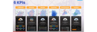
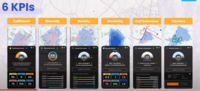
[[KPIs to Measure Urban Performance of 15 Min City]] | |
| KPIs to Measure Urban Performance of 15 Min City | ||
|
[[KPIs to Measure Urban Performance to measure the performance of 15 Min City]] | |
| 6 KPIs to Measure Urban Performance of 15 Min City. | ||

|
[[Kashiwanoha Smart City Project]] | |
| The Kashiwanoha smart city project (first described as Kashiwanoha International Campus Town Initiative) is a planned from scratch city project, involving a greenfield smart city vision, situated around Kashiwanoha Campus Station. Kashiwonoha smart city project is a privately-led project, with Mitsui Fudosan as the main developer. It was also the owner the previous owner of the golf course on which construction work of the project were first based. However, Kashiwa city was designated as one of the "FutureCities" by the national government in 2011, making Kashiwanoha new town project eligible for government subsidies. | ||
|
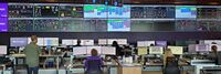
[[Lake Tahoe Basin End Warning System and Bi-state Next Gen 911 Dispatch and Traffic Management Center]] | |
| The Lake Tahoe Basin End Warning Systems, will provide a cross-jurisdictional system that emergency managers will use to improve performance, while providing predictive insights and more connectivity between first responders, traffic and transit operations, and the public. The system will integrate Smart Street lights, SaS, and publicly available datasets to provide a better understanding of visitors in the Lake Tahoe Basin including travel movements and duration of stay, emergency roadway issues including closures or hazards caused by landslides, fires, toxic spills, avalanches, tree falls, and power outages. These criteria will be considered for real-time detection and notification systems and reduction in secondary incidents.
First responders and transportation agencies of the Lake Tahoe and Truckee region would also like to develop a Bi-State preliminary exploratory study of a consolidated command center for dispatch services of fire and emergency services with an integrated traffic management center that is consistent with the Commerce Department’s National Telecommunications and Information Administration (NTIA) and the Transportation Department’s National Highway Traffic Safety Administration (NHTSA) | ||
|
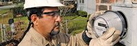
[[Leveraging Existing Automated Meter Reading for a Smart Alert Response Technology]] | |
| The City of Houston is 10,062 square miles (26,060 km²), with 6,950 miles (11,184 km) of sewer pipeline ranging in size from 6 to 144 inches (15 to 365cm) in diameter and including approximately 123,000 manholes. Houston uses the Automated Meter Reading (AMR)/Advanced Meter Infrastructure (AMI) network for identification and mitigation of Sanitary Sewer Overflows as part of the City's system-wide operation, maintenance and management plan. Houston calls this plan AIM (Automated Infrastructure Monitoring). | ||

|
[[Lighting Infrastructure as a Service Platform]] | |
| Lighting infrastructure is centrally located in city, close to people and activities. It provides excellent opportunity to collect and deliver information and services beyond lighting. Project targets to employ lighting infrastructure as the IoT backbone for different services in urban environments. | ||