Semantic search

|
[[LinkNYC]] | |
| LinkNYC is a first-of-its-kind communications network that will bring the fastest available municipal Wi-Fi to millions of New Yorkers, small businesses, and visitors. The five-borough LinkNYC network, which will be funded through advertising revenues, will be built at no cost to taxpayers and will generate more than $500 million in revenue for the City over the first 12 years. | ||

|
[[Low Carbon Island and Smart Bay Project]] | |
| Penghu County is located on the central point of Taiwan Strait. The population of Penghu is 103, 000 in 2017 and there are about 1 million tourists visit Penghu per year. Since 2011 Penghu implemented the Low Carbon Island project and now will start the following second phase from 2018 to 2021. This project includes solar and wind power renewable energy development, offshore wind farm investment, smart grid system, electric vehicle, water and energy management system of small island and smart transportation service. | ||
|
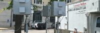
[[Low-cost Air Quality Monitoring RAMPs in Pittsburgh PA]] | |
| The proposed project will deploy 30 Real Time, Multi-Pollutant Sensors (RAMPs) at traffic intersections currently managed by the Scalable Urban Traffic Control (SURTRAC) Intelligent Traffic control system, an adaptive traffic control system that optimizes traffic flows in the East Liberty corridor of Pittsburgh (see figure below). These RAMP sensors are portable, low-cost sensors for gaseous air pollutants and particulate matter (PM) that have been developed at Carnegie Mellon and will be mounted on utility poles, using the access already provided by SURTRAC for their equipment.
The existing SURTRAC architecture in East Liberty provides an important platform to study urban air quality through unprecedented approaches that could be replicated across city neighborhoods and which could eventually be scaled across the Pittsburgh metropolitan region. No other system like this currently exists. | ||

|
[[Lutece]] | |
| Lutece is an open source platform developed by the City of Paris to help you develop digital solutions. Honed for cities’ use through almost 20 years of development, Lutece has evolved into multifaceted platform with more than 400 plugins and modular architecture that will enable your specific needs and enhance your users' digital experience. | ||

|
[[MAGIC Smart Home Smart Community Project]] | |
| Install sensors and an in-home intelligent integration platform to demonstrate telemedicine features in a medically vulnerable group home setting; connected by Software Defined Networking (SDN) to other interested community partners utilizing the Westminster Fiber Network, to create the fundamental operational unit of a truly Smart Community. | ||
|
[[Managing Cybersecurity and Privacy Risk for Smart Public Safety IoT Devices and Systems]] | |
| This use case provides a notional approach to address cybersecurity and privacy risks related to incorporating IoT in smart public safety applications. This use case posits some of the major activities, key stakeholders, and potential resources for each step of the cybersecurity and privacy risk management process. | ||

|
[[Microclimate Prediction for Willamette Valley Vineyards]] | |
| Leveraging regional weather data and weather stations at individual vineyards to develop a regional prediction for when bud break and bloom will happen as well as highly specific predictions of those same dates for individual vineyards. Additional opportunities to predict and develop alerts for freezes, powdery mildew, and other events targeted at specific vineyards. | ||
|
[[Microgrids Sustainable resilient mobile power for disasters]] | |
Deploy mobile, rechargeable power units throughout city departments to intelligently manage and measure energy usage. This can result in reduced energy costs through time shifting consumption from daytime to nighttime and peak shaving to lower demand charges. The mobile chargers would be remotely monitored and available to be deployed in the immediate aftermath of a catastrophe.
| ||
|
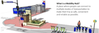
[[Minneapolis Mobility Hubs]] | |
| In 2019, the City of Minneapolis launched a mobility hub pilot program to increase access to convenient, low or no carbon transportation options, including transit, shared scooters and Nice Ride bicycles. | ||

|
[[Move PGH]] | |
| Move PGH unites diverse mobility services and created to provide Pittsburghers with more choices to get everywhere you need and want to go. Think of it as your one-stop-shop for all your transportation needs in the City of Pittsburgh. In coordination with the Department of Mobility and Infrastructure (DOMI) and powered by a group of the city's premiere mobility operators dubbed the Pittsburgh Mobility Collective, Move PGH will create a streamlined and accessible experience for car-free urban mobility. | ||
|
[[Multi-modal Trip Planner]] | |
| Develop a tool enables commuters to plan trips encompassing public transit, ride-sharing services, bike rentals, and pedestrian routes. By integrating multiple modes of transportation, this enhanced trip planner aims to make commuting more seamless and convenient, empowering individuals to choose sustainable alternatives to private vehicles. | ||

|
[[My Digital Data Locker Baltimore]] | |
| For those staying in a shelter or shuttling between other people’s homes, keeping track of these vital documents can be near impossible. They also can be lost, destroyed or stolen.
Recognizing that this was blocking some people from securing stable housing, the city of Baltimore this year launched an innovative program — My Digital Data Locker — to help people store and keep track of key documents. | ||

|
[[Neighborhood Data for Social Change]] | |
| The Neighborhood Data for Social Change (NDSC) platform is a free, publicly available online resource for civic actors to learn about their communities. | ||
|
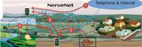
[[NerveNet: Regional Resilient IoT Platform]] | |
Project Description Points
| ||

|
[[Next Generation Resilient Warning Systems for Tornados and Flash Floods]] | |
| The project aims to revolutionize severe weather warnings through Next Gen communications and networking. Focusing on hyper-local, user-driven, context-aware alerts, it leverages mobile phones and hyper-local data for customized warnings, enhancing response and outcomes. | ||

|
[[NoTraffic Pilot in Redlands CA]] | |
Key Deliverables
| ||
|
[[Non-Revenue Water Monitoring and Reduction Using Advanced LTE Communications Gwinnet County GA]] | |
| Install the first LTE communications base instrumentation in a pilot area and develop algorithms for understanding the elements of non-revenue water (lost water) as a means to reduce the cost of water delivery, improve management of scarce water resources, improve system operations, and save money for customers. The pilot will use advanced instrumentation with embedded LTE communications chips, such as smart water meters and pressure sensors to produce data to be used in the development of the software algorithms. | ||

|
[[OMSI Development]] | |
| The OMSI Consortium is soliciting subject matter experts and qualified vendors to participate in a series of short virtual workshops during the months of October-December 2020, culminating in a Q1 2021 Request for Proposal (RFP) to build a showcase integrated district infrastructure solution to serve the Oregon Museum of Science and Industry’s 23-acre site with the potential to develop up to 3 million square feet of new, low-carbon, mixed-use construction in Portland’s Central City Plan District. Workshop details will be released to confirmed participants. | ||
|
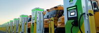
[[Oakland 100% electric school bus fleet]] | |
| The Oakland Unified School District, in collaboration with Zum and utility provider PG&E, has achieved a groundbreaking milestone by transitioning to a 100% electric school bus system with vehicle-to-grid (V2G) technology. This initiative, the first of its kind in the US, involves a fleet of 74 electric buses equipped with bidirectional chargers managed through Zum's AI-enabled platform. By becoming emissions-free and serving as a Virtual Power Plant (VPP), this fleet not only addresses environmental concerns but also contributes 2.1 gigawatt hours (GWh) of energy back to the grid annually. This transformative project not only benefits the Oakland community but also sets a precedent for other districts, with plans to electrify school bus fleets in San Francisco and Los Angeles next. | ||
|
[[Oil Gas well produced water localized treatment and recycle Coudersport Borough Eulalia Township PA USA]] | |
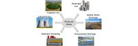
| Establish medium volume produced water treatment facilities near clusters of oil & gas well pads for localized treatment of the produced water. These facilities separate the produced water into metals for disposal, then salt for resale, and potable water for reuse or discharge to the local sanitation authority publicly owned treatment works (POTW). The facilities would be industrial waste water pre-treatment customers of the POTW. | ||

|
[[Online Meeting & Collaboration Tools - Commercial]] | |
| COVID19 has created a need for organizations and individuals to connect and collaborate remotely using conferencing tools. | ||

|
[[Online Power Quality Monitor for Electric Utilities and Municipalities]] | |
| Monitor Power Quality parameters such as voltage dips, sags, harmonics, THD, TDD and transients; monetize losses due to power quality; and minimize the troubleshooting time using our Power SCADA tool anywhere in Real Time. Get alarms and reports straight to your device in time. | ||

|
[[Open 988]] | |
| 988 has been designated as the new three-digit dialing code that will route callers to the National Suicide Prevention Lifeline. While some areas may be currently able to connect to the Lifeline by dialing 988, this dialing code will be available to everyone across the United States starting on July 16, 2022. | ||
|
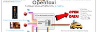
[[Open Data API Platform and Analysis of Taxi Dispatch]] | |
| Establish an Open data / API platform and integrate municipal and business data to be the foundation of the intelligent city for value-added applications. According to visually data display assist government to make decision effectively and let the citizen know the city governance. | ||
|
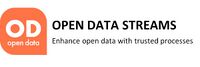
[[Open Data STREAMS]] | |
| This project involves an evaluation framework for open datasets published by the City of Portland. The goal is to create a data analysis tool which provides quality assurance for datasets made available between bureaus and to the public. | ||
| [[Open Network for Education and Skilling Transactions]] | ||
| Beckn-based Open Network for Education and Skilling Transactions (ONEST) | ||

|
[[Open Participatory Budgeting]] | |
| Participatory budgeting (PB) is process in which citizens decide how to allocate part of a municipal or public budget through a process of democratic deliberation and decision-making. Participatory budgeting allows citizens or residents of a locality to identify, discuss, and prioritize public spending projects, and gives them the power to make real decisions about how money is spent. | ||
|
[[Open Wi-Fi Maps and Lists (by US state)]] | |
| States are compiling lists of open Wi-Fi access points for residents who do not have home broadband access. While accessing these sites may be in violation of social distancing and shelter-in-place directives, some people may choose to use this option.
Open Wi-Fi SSIDs are potentially a security risk to users. Use of VPNs and secure website is highly recommended. | ||
|
[[Open platform for scalable and multi-domain IoT applications for smart cities]] | |
Objectives
| ||

|
[[OpenGrid]] | |
| OpenGrid is an interactive, map-based platform for exploring open data sets in an easy-to-use, map-based interface. OpenGrid enables municipalities to offer residents, businesses, and communities a better way to interact with public data. Users can perform advanced queries to filter data as well as search within custom boundaries or based on the user's location. | ||
|
[[Oregon Data Catalog]] | |
| The Oregon Data Catalog is a platform for managing and publishing data sets that are relevant to the state of Oregon in the United States. The platform is based on CKAN, which is a free and open-source software platform for managing and publishing data. | ||
|
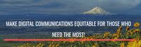
[[Oregon Digital Safety Net]] | |
| Digital communications are necessary to participate in mainstream life today.
Those of us who are fortunate enough to be employed, housed, and reasonably healthy and stable, financially and emotionally, know how dependent we are on our digital devices to navigate our daily lives. | ||
|
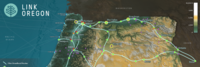
[[Oregon middle-mile fiber broadband network]] | |
| Link Oregon, the non-profit, middle-mile broadband network serving Oregon’s
public and non-profit sectors, delivered the first two phases of its statewide network backbone in June 2021, having successfully lit nearly 2,000 route-miles of fiber-optic cable and deployed more than 50 service locations across Oregon. | ||

|
[[PA2040 Public Wi-Fi]] | |
| Create wireless mesh backhaul infrastructure as part of smart city IoT deployment throughout the 1700 to 1900 blocks of Pennsylvania Avenue, NW, Washington DC to enable public connectivity to services and enhanced connectivity for government operations and public safety. Involves city technology, planning, and transportation agencies, local Business Improvement District (BID), federal District planning agency, and technology solution providers. | ||
|
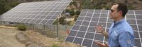
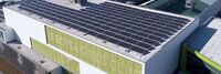
[[PGE Renewable Development Fund]] | |
| The PGE Renewable Development Fund awards grants for clean energy projects in the community. These are funded by PGE customers who choose Green Future renewable energy programs. | ||

|
[[Parkrose Community Village]] | |
| WeShine’s first micro-village. Micro-villages are “transitional shelters”, designed to provide safety, privacy, hygiene, and community to people seeking permanent housing. PCV will include paid staff, lockable sleeping pods, laundry, showers, toilets, fencing, and a community building. Volunteers will help with art, gardening, financial literacy, food, pet care, and medical/nursing needs. | ||

|
[[Personal Access System for Services (PASS)]] | |
| Social services are programs or services designed to support individuals and communities in need. They provide assistance with basic needs such as food, housing, and clothing, as well as health and medical care, education and job training, child care, support for individuals with disabilities or mental health conditions, and aging and elder care. These services are intended to improve the quality of life for individuals and communities and help individuals achieve self-sufficiency. | ||
|
[[Personalized Dashboard for the Residents]] | |
| YoGov and the City of San Leandro partnered to create an Amazon-like dashboard for city residents, helping residents quickly and easily find services most relevant to them. The dashboard also promotes city services, events, and news that are important to the city. | ||

|
[[Piloting lighting infrastructure as a service platform for smart lighting solutions]] | |
| Lighting infrastructure is centrally located in city, close to people and activities. It provides excellent opportunity to collect and deliver information and services beyond lighting. Project targets to employ lighting infrastructure as the IoT backbone for different services in urban environments. | ||

|
[[Pittsburgh building portfolio cyber-secure, real-time utility data integration and AI analysis]] | |
| This project is expanding on a successful 5 building pilot with the City of Pittsburgh to integrate most of the 167 city building’s real-time (15 minute interval) utility and usage data in the BuildFit application and BOSS Controls Smart Plugs. Using visualizations and artificial intelligence algorithms developed at the Carnegie Mellon University (CMU) School of Architecture (SOA), BuildFit will then provide recommendations for utility savings, sub-metering and indoor environmental quality (IEQ) optimization. The project will also allow for comprehensive support for the Pittsburgh Building Benchmarking Ordinance and Regional Energy Strategy (Power of 32) and 2030 District Challenge to improve energy resiliency and efficiency. Another important feature of the software and hardware components of this project will be defining and implementing the cyber security standards for smart building components and software in conjunction with NIST and other key government agencies. This will also include the first Smart Building/Smart City independent training, testing and certification lab at the Energy Innovation Center in Pittsburgh, PA | ||

|
[[Point Cloud City - Hancock County Mississippi]] | |
| Develop approaches which improve indoor mapping techniques and datasets in the US to make them more common and available for use nationwide. | ||

|
[[Point Cloud MAP901 Building Rich Interior Hazard Maps for First Responders]] | |
| Build a catalog of 3D maps with clear identification of safety-related objects to help first responders navigate safely and quickly during emergency/crisis. | ||
|
[[Portland Connected Intelligent Transportation]] | |
| This project focuses on developing a sensor-connected “smart” corridor in Portland where transit data, traffic signalization, and air quality sensing are made available in a data portal with data visualization and analytics to improve transportation options, public health, economic development and civic engagement. | ||
|
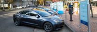
[[Portland Electric Avenue]] | |
| Electric Avenue officially opened at the World Trade Center Portland in 2016 and is located on the Northside of Southwest Salmon Street in downtown Portland. It offers street access charging stations to allow visitors to charge their personal electric vehicles while visiting the World Trade Center and neighboring offices. | ||

|
[[PortlandMaps - Open Data]] | |
| PortlandMaps delivers site-specific property information, neighborhood crime statistics, aerial photos, school information, and tons of additional map data for the City of Portland and beyond. | ||
| [[File:|200px|x160px|link=Potential Funding and Channels for Emergency Broadband Deployments]] | [[Potential Funding and Channels for Emergency Broadband Deployments]] | |

|
[[PowerMatcher Blockchain Transactive Energy]] | |
| This project makes use of PowerMatcher a software developed in the Netherlands. | ||

|
[[Productivity Tools - Commercial]] | |
| During this difficult time of change and disruption, businesses and organizations must be productive and nimble while optimizing cash flow and streamlining operations. | ||

|
[[Project GRACE]] | |
| The present Public Key Infrastructure (PKI) is known to be inadequate for the current scale of the Internet and the situation is exacerbated with the advent of IoT. Project GRACE (Graceful Remediation with Authenticated Certificateless Encryption) implements a security architecture using an advanced form of pairing-based cryptography called Verifiable Identity-based Encryption (VIBE) to provide a simple, scalable and secure key management for the cloud services, the IoT and indeed the Critical Information Infrastructure (CII) which are otherwise vulnerable to the extant and new cyber-physical attacks. | ||
|
[[Protecting user Data in the Smart City scenario]] | |
| Data is exchanged intensively within a Smart City, the correct usage of such information is vital to provide a better service to the citizens. Protecting user’s details is the key of a broader adoption of any application with intense data exchange and exploitation. | ||