Point Cloud MAP901 Building Rich Interior Hazard Maps for First Responders
Jump to navigation
Jump to search
| Point Cloud MAP901 Building Rich Interior Hazard Maps for First Responders | |
|---|---|

| |
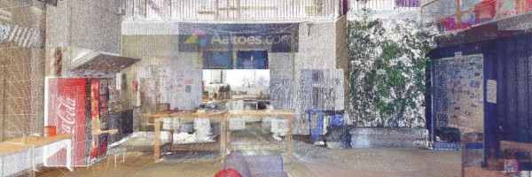
 3D Indoor Point Cloud | |
| Team Organizations | City of Memphis University of Memphis |
| Team Leaders | Gertrude Moeller Lan Wang Eddie Jacobs |
| Participating Municipalities | Memphis TN |
| Status | Implemented |
| Document | None |
Description
Build a catalog of 3D maps with clear identification of safety-related objects to help first responders navigate safely and quickly during emergency/crisis.
Challenges
Currently there is lack of availability of rich interior maps to first responders. It delays response time of first responders. The available maps do not have any details of objects of interest of First Responders. This lack of information impacts first responder's safety and efficiency. With smart maps they can easily navigate at incident site and take action.
Solutions
The project will collect data to build 3D indoor maps with annotated objects of interest (e.g. exits and fire extinguishers) for first responders.
Major Requirements
- Establish project team
- Develop project communication and deliverables schedule
- Consolidate survey site details required for survey
- Prepare survey schedule
- Send out notification to sites with survey timings necessary details including privacy measures to be taken
- Perform survey by scanning the buildings
- Data analysis and annotation
- Develop GIS application
- Review and test the application
- Project conclusion
Performance Targets
| Key Performance Indicators (KPIs) | Measurement Methods |
|---|---|
|
|
Standards, Replicability, Scalability, and Sustainability
- Methods used during the project will be used to generate similar 3D maps for buildings on a large scale
- The indoor maps catalog of a diverse set of buildings can be used as benchmark for 3D indoor maps generation of other buildings with similar characteristics
Cybersecurity and Privacy
- Access to survey data and GIS application will be provided only to authorized personnel only on request basis.
- We will encrypt our data with per-namespace keys to prevent unauthorized access and give fine-granularity access to authorized users.
- For privacy, we will use automated methods to remove humans in our camera images.
Impacts
- Reduction in first responder’s navigation time at site of crisis/emergency
- Reduced response time with help of smart maps providing information about objects of interest of First responders.
Demonstration/Deployment
- Survey buildings using LiDAR backpack, 3D camera, GPS, temperature, humidity, and sound sensors
- 7 buildings in Memphis, TN
- 1.86 million sqft. space
- Equipment: GVI LiBackpack with Velodyne PUCK LiDAR, Insta360 Pro 2 camera
- Leverage Deep Neural Networks to process, analyze and annotate data with objects of interests for first responders
- ArcGIS based app for first responders and a webpage with catalog of 3D indoor maps