Semantic search
| [[Open Network for Education and Skilling Transactions]] | ||
| Beckn-based Open Network for Education and Skilling Transactions (ONEST) | ||

|
[[Open Participatory Budgeting]] | |
| Participatory budgeting (PB) is process in which citizens decide how to allocate part of a municipal or public budget through a process of democratic deliberation and decision-making. Participatory budgeting allows citizens or residents of a locality to identify, discuss, and prioritize public spending projects, and gives them the power to make real decisions about how money is spent. | ||
|
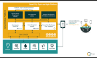
[[Open platform for scalable and multi-domain IoT applications for smart cities]] | |
Objectives
| ||

|
[[OpenGrid]] | |
| OpenGrid is an interactive, map-based platform for exploring open data sets in an easy-to-use, map-based interface. OpenGrid enables municipalities to offer residents, businesses, and communities a better way to interact with public data. Users can perform advanced queries to filter data as well as search within custom boundaries or based on the user's location. | ||

|
[[Oregon Data Catalog]] | |
| The Oregon Data Catalog is a platform for managing and publishing data sets that are relevant to the state of Oregon in the United States. The platform is based on CKAN, which is a free and open-source software platform for managing and publishing data. | ||

|
[[Oregon Digital Safety Net]] | |
| Digital communications are necessary to participate in mainstream life today.
Those of us who are fortunate enough to be employed, housed, and reasonably healthy and stable, financially and emotionally, know how dependent we are on our digital devices to navigate our daily lives. | ||
|
[[Oregon middle-mile fiber broadband network]] | |
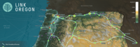
| Link Oregon, the non-profit, middle-mile broadband network serving Oregon’s
public and non-profit sectors, delivered the first two phases of its statewide network backbone in June 2021, having successfully lit nearly 2,000 route-miles of fiber-optic cable and deployed more than 50 service locations across Oregon. | ||

|
[[PA2040 Public Wi-Fi]] | |
| Create wireless mesh backhaul infrastructure as part of smart city IoT deployment throughout the 1700 to 1900 blocks of Pennsylvania Avenue, NW, Washington DC to enable public connectivity to services and enhanced connectivity for government operations and public safety. Involves city technology, planning, and transportation agencies, local Business Improvement District (BID), federal District planning agency, and technology solution providers. | ||

|
[[PGE Renewable Development Fund]] | |
| The PGE Renewable Development Fund awards grants for clean energy projects in the community. These are funded by PGE customers who choose Green Future renewable energy programs. | ||

|
[[Parkrose Community Village]] | |
| WeShine’s first micro-village. Micro-villages are “transitional shelters”, designed to provide safety, privacy, hygiene, and community to people seeking permanent housing. PCV will include paid staff, lockable sleeping pods, laundry, showers, toilets, fencing, and a community building. Volunteers will help with art, gardening, financial literacy, food, pet care, and medical/nursing needs. | ||

|
[[Personal Access System for Services (PASS)]] | |
| Social services are programs or services designed to support individuals and communities in need. They provide assistance with basic needs such as food, housing, and clothing, as well as health and medical care, education and job training, child care, support for individuals with disabilities or mental health conditions, and aging and elder care. These services are intended to improve the quality of life for individuals and communities and help individuals achieve self-sufficiency. | ||

|
[[Personalized Dashboard for the Residents]] | |
| YoGov and the City of San Leandro partnered to create an Amazon-like dashboard for city residents, helping residents quickly and easily find services most relevant to them. The dashboard also promotes city services, events, and news that are important to the city. | ||

|
[[Piloting lighting infrastructure as a service platform for smart lighting solutions]] | |
| Lighting infrastructure is centrally located in city, close to people and activities. It provides excellent opportunity to collect and deliver information and services beyond lighting. Project targets to employ lighting infrastructure as the IoT backbone for different services in urban environments. | ||

|
[[Pittsburgh building portfolio cyber-secure, real-time utility data integration and AI analysis]] | |
| This project is expanding on a successful 5 building pilot with the City of Pittsburgh to integrate most of the 167 city building’s real-time (15 minute interval) utility and usage data in the BuildFit application and BOSS Controls Smart Plugs. Using visualizations and artificial intelligence algorithms developed at the Carnegie Mellon University (CMU) School of Architecture (SOA), BuildFit will then provide recommendations for utility savings, sub-metering and indoor environmental quality (IEQ) optimization. The project will also allow for comprehensive support for the Pittsburgh Building Benchmarking Ordinance and Regional Energy Strategy (Power of 32) and 2030 District Challenge to improve energy resiliency and efficiency. Another important feature of the software and hardware components of this project will be defining and implementing the cyber security standards for smart building components and software in conjunction with NIST and other key government agencies. This will also include the first Smart Building/Smart City independent training, testing and certification lab at the Energy Innovation Center in Pittsburgh, PA | ||

|
[[Point Cloud City - Hancock County Mississippi]] | |
| Develop approaches which improve indoor mapping techniques and datasets in the US to make them more common and available for use nationwide. | ||

|
[[Point Cloud MAP901 Building Rich Interior Hazard Maps for First Responders]] | |
| Build a catalog of 3D maps with clear identification of safety-related objects to help first responders navigate safely and quickly during emergency/crisis. | ||
|
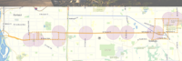
[[Portland Connected Intelligent Transportation]] | |
| This project focuses on developing a sensor-connected “smart” corridor in Portland where transit data, traffic signalization, and air quality sensing are made available in a data portal with data visualization and analytics to improve transportation options, public health, economic development and civic engagement. | ||
|
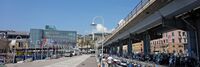
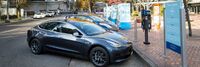
[[Portland Electric Avenue]] | |
| Electric Avenue officially opened at the World Trade Center Portland in 2016 and is located on the Northside of Southwest Salmon Street in downtown Portland. It offers street access charging stations to allow visitors to charge their personal electric vehicles while visiting the World Trade Center and neighboring offices. | ||

|
[[PortlandMaps - Open Data]] | |
| PortlandMaps delivers site-specific property information, neighborhood crime statistics, aerial photos, school information, and tons of additional map data for the City of Portland and beyond. | ||

|
[[PowerMatcher Blockchain Transactive Energy]] | |
| This project makes use of PowerMatcher a software developed in the Netherlands. | ||

|
[[Project GRACE]] | |
| The present Public Key Infrastructure (PKI) is known to be inadequate for the current scale of the Internet and the situation is exacerbated with the advent of IoT. Project GRACE (Graceful Remediation with Authenticated Certificateless Encryption) implements a security architecture using an advanced form of pairing-based cryptography called Verifiable Identity-based Encryption (VIBE) to provide a simple, scalable and secure key management for the cloud services, the IoT and indeed the Critical Information Infrastructure (CII) which are otherwise vulnerable to the extant and new cyber-physical attacks. | ||
|
[[Protecting user Data in the Smart City scenario]] | |
| Data is exchanged intensively within a Smart City, the correct usage of such information is vital to provide a better service to the citizens. Protecting user’s details is the key of a broader adoption of any application with intense data exchange and exploitation. | ||

|
[[ROSE - Real Time Operational Smart Grid for Europe]] | |
The ROSE project is
| ||
|
[[Real Time Resilience]] | |
Objectives
| ||

|
[[Reduced customs clearance time with virtual extension of sea ports]] | |
| Develop and deploy electronic cargo tracking solutions in different settings (sea port, dry port and manufacturing FTZ) and across geographies (traversing from landlocked locations to ports, in East Africa and in Asia), for expedited customs clearance and enhanced trade facilitations. The solution is integrated across technology stacks, including end-devices, platforms and analytics, by ecosystem of accredited vendors. Involves security/field enforcement officials, customs officials, application developers, telco service providers, shippers and consignees. | ||
|
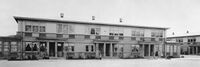
[[Regenerative Urbanism Vanport]] | |
| Vanport, Oregon was a temporary housing project built in 1942 to address a wartime housing shortage in Portland. | ||
|
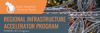
[[Regional Infrastructure Accelerator Program]] | |
| The Pacific NorthWest Economic Region (PNWER) is one of five organizations awarded the U.S. Department of Transportation's Build America Bureau Regional Infrastructure Accelerator (RIA) program grant in its first iteration. PNWER will use grant funds to establish a Regional Infrastructure Accelerator for the Pacific Northwest. The RIA will serve as a convener for transportation projects across the five state member region, specifically multistate and multi-jurisdictional initiatives that are needed, but lack funding for completion. | ||

|
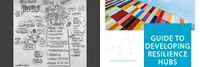
[[Resilience HUB - East Multnomah]] | |
| Resilience Hubs are community-serving facilities augmented to support residents and coordinate resource distribution and services before, during, or after a natural hazard event. They leverage established, trusted, and community-managed facilities that are used year-round as neighborhood centers for community-building activities. Resilience Hubs can equitably enhance community resilience while reducing greenhouse gas emissions and improving local quality of life for our communities. They have the potential to reduce burden on local emergency response teams, improve access to public health initiatives, increase the effectiveness of community-centered institutions and programs. | ||
|
[[Resilience HUB - NIST Guide]] | |
| Natural, technological, and human-caused hazards take a high toll on communities, but the costs in lives, livelihoods and quality of life can be reduced by better managing disaster risks. Planning and implementing prioritized measures can strengthen resilience and improve a community's abilities to continue or restore vital services in a more timely way, and to build back better after damaging events. That makes them better prepared for future events and more attractive to businesses and residents alike. | ||

|
[[Resilience HUB - Vibrant Hawaii]] | |
| A goal of the Resilience Hub initiative is to build individual capacity and community networks to be resilient and ready for anything. To get there, Vibrant Hawai'i hosted a Resilience Leadership Academy (RLA) - a monthly development program with curated content by local experts. | ||

|
[[Responder to Vehicle Communication for Public Safety - HAAS Alert]] | |
| Leverage a platform that allows for alerting drivers when first responders are in route nearby. The platform will use existing mobile networks within the city to send the alerts to drivers on their phones and in-dash through our partnerships with automotive companies. The project will assist in moving drivers out of the way of first responders which will ultimately reduce response times, reduce the number of vehicles driving towards an active scene, and look at learnings from analytics and metrics for how long first responders were in lights and sirens mode. | ||

|
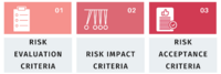
[[Risk Assessment and Prioritization in the Smart City Cyber Resilience Planning Process]] | |
| This use case summarizes an engagement between a GCTC Action Cluster member, Adaptable Security Corp (ADA), and a California municipality, focusing on how the risk management process, with a particular focus on risk assessment and prioritization, played a critical role in the overall cyber resilience planning process. The content covered in this use case primarily aligns with the Prepare, Select, Assess, and Monitor steps of the RMF. | ||
|
[[Risk Assessment in the County of San Mateo, California]] | |
| This use case describes how risk assessment has been implemented in the County of San Mateo, California, and identifies activities that align most closely with the Step 0: Prepare and Step 6: Monitor steps of the risk management process. However, the assessment process and the outputs from the assessment also involve elements from and inform all of the other risk management steps (i.e., Step 1: Categorize, Step 2: Select, Step 3: Implement, Step 4: Assess, Step 5: Authorize). Refer to Appendix B of this Guidebook for an example of the risk assessment questionnaire and its application. | ||
|
[[Risk Management in a Privacy-Specific Context]] | |
| This use case describes how the risk management concepts and processes presented in this Guidebook apply in privacy-specific applications. Given the overlapping relationship of cybersecurity and privacy, much of the information in this use case may sound similar to, or even identical to, aspects of cybersecurity risk management. This reinforces the notion that cybersecurity and privacy are closely related and should generally be considered in tandem. | ||

|
[[Rose City Resource]] | |
| The Street Roots Rose City Resource (RCR) is a 4’x 4′, 104 page guide that is the most comprehensive, updated list of services for people experiencing homelessness and poverty in Multnomah, Washington and Clackamas counties. | ||

|
[[SMART Emergency Medical and First Response Multiteam Systems]] | |
SMART Emergency Medical Teams will help inter-disciplinary teams improve transition-of-care quality, promote situational awareness, and enhance the efficacy of simulation debriefing.
| ||

|
[[Safe Community Awareness and Alerting Network (SCALE)]] | |
* Connect homes to detect emergency events and alert residents via phone or app, and initiate contacting first responders
| ||

|
[[Saitama City Smart Community Project]] | |
| We developed a Smart Community Information Platform (SCIP) for achieving security and privacy management of smart city data and providing smart city data services considering time-, privacy-, and location- critical problems. We are implementing the information platform for providing smart town services for 32,000 residents in 230-hectare area of Misono Town, Saitama City as a testing site of SCIP. | ||

|
[[San Mateo County Public WiFi]] | |
| We live in the heart of Silicon Valley, but even in San Mateo County we have a significant digital divide between those with high speed Internet access and those with slow speed or no access. The County believes that providing high speed Internet access is the 21st century equivalent to building roads. Providing the infrastructure so that all residents have equal access to online resources is critical to supporting our shared vision of a healthy, safe, prosperous, livable, environmentally conscious, and collaborative community. | ||

|
[[Santa Clara County Office of Education CBRS Networks]] | |
| Santa Clara County Office of Education and Joint Venture Silicon Valley are cooperating with industry leaders to deploy CBRS broadband networks for addressing distance learning and homework gap challenges. | ||
|
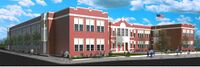
[[School Organized Locally Assisted Community Emergency‐Management]] | |
| The School Organized Locally Assisted Community Emergency‐Management (SOLACE) project focused on the use of a community school as a community resilience hub for its surrounding community. Community Resilience Hubs (CRHs) can be defined as community‐serving facilities augmented to support residents and coordinate resource distribution of resources and services to the surrounding community. This project focused specifically on the use of a CRM to support community member needs before, during, or after a natural hazard event and on developing a community‐led sociotechnical infrastructure framework for adapting a public school (Buckman Elementary School) as the pilot CRH. In 2022, this project received a NSF Planning Grant. | ||

|
[[Secure Cloud Architecture SC3-cpSriA]] | |
| Smart cities run largely on cloud services for efficiency and affordability reasons. Residents, government agencies, and small and medium businesses can benefit from an Architecture or Framework for privacy and rights-inclusive security practices across smart city and community cloud services. First, the City of Syracuse, New York, USA, in cooperation with Syracuse University and SC3-cpSriA Action Cluster(Smart City and Community Challenge Cloud privacy security rights inclusive Architecture) consider how the Architecture guidelines may apply. The SC3-cpSriA Action Cluster welcomes new members to broaden the debate. First, smart streetlight networks, catch basin monitoring, and water metering projects may consider if and how security, privacy, data protection and rights-inclusive cloud architecture guidelines may be followed. The ethics for facial recognition, machine learning and artificial intelligence systems and cloud services in future smart cities with privacy, security and rights-inclusive architecture will also be reviewed. Can architecture guidelines help protect citizens rights and encourage growth of smart city open data lakes, encouraging civic engagement and data privacy security and rights-inclusive innovation, entrepreneurship and economic development? | ||

|
[[Small Donor Elections]] | |
| The Small Donor Elections program seeks to reduce the influence of money in politics and encourage election of people to City office who are reflective of and accountable to all Portlanders. | ||

|
[[Smart Beyoğlu: Digital Recollection of Beyoğlu]] | |
| Smart Beyoğlu is a mobile application project which provides fast access to all transactions related to the municipality and solutions for the citizens and business owners in Beyoğlu. Local and foreign tourists can get a lot of information such as details, location of business, hotels, restaurants etc., historical buildings and cultural events. It is a mobile app project that allows them to set up a network. | ||

|
[[Smart Buildings Action Cluster]] | |
| SBAC will focus on smart buildings within the environment of communities on a local and regional level. There are a number of issues pertaining to communications, connectivity and integration that need to be resolved. This group will discuss these issues and others that arise over time, as well as work to provide best practices and prototype demonstrations of such. | ||

|
[[Smart Car Talk]] | |
Key Deliverables
| ||

|
[[Smart Cities Dashboard in the City of Bellevue WA]] | |
Install a pilot GIS-based visual dashboard to provide improvements in the following sectors:
| ||

|
[[Smart City Diaries TV Video Series]] | |
| Smart City Diaries is a documentary television and podcast series that showcases the phenomenon of digital transformation in small and large cities in the developed and developing world. Destination cities will have undertaken smart city initiatives to transform the way they manage their city operations and provide information and services to their residents. Each city has unique physical, social and cultural qualities; the series highlights individuals across cultures to understand how rapidly changing technologies impact how they live, work, play and learn.
The series will be hosted by a mother and daughter team: Deborah Acosta and Anna Acosta. Their perspectives differ as do their attitudes and levels of comfort with new technologies: one is a baby boomer, the other a millennial. One was CIO for a small California city, the other is a musician, songwriter, social justice blogger and social media expert. They are both smart and sassy, ready to explore a range of cities and the people who are impacted by smart city digital transformations. Through the eyes of these two women, each episode reveals how unique locations approach meeting the quality-of-life demands of residents, businesses and visitors through increased use of technology in an era of the Internet of Things, shifting populations and shrinking budgets and resources. | ||

|
[[Smart City Vision Strategic Planning and Digital Transformation Methodology]] | |
* The Smart City methodology helps people imagine and learn about future state scenarios for their lives, businesses, and cities. The process produces clearly defined product solutions and projects they want to create, design, and implement.
| ||

|
[[Smart City in the Sunshine State]] | |
The project includes the evaluation, selection and implementation of three main aspects of the County’s SCADA system:
| ||