|
|
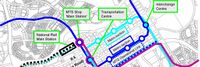
Abuja City Integrated Transportation System
|
| Sustainable Mass Abuja Rapid Transit (SMART) is an easier, efficient and seamless means of utilizing the city’s public mass transit bus service.
Abuja Urban Mass Transit has over 500 buses conveying an estimated 1000 passengers daily. The proposed project will equip 100 buses with devices to generate and transmit real time data and information between drivers, commuters, city transport officials and the general public.
The project targets increased ridership and revenue generation from the combination of multiple methods of electronic payments, bus routing, location tracking as well as online bus schedule service.
|
|
|

|
|
Big Data and Artificial Intelligence for Road Infrastructure Sustainability
|
| Provide an efficient and effective solution using artificial intelligence and smartphones to monitor and maintain roadway infrastructure with a data-driven approach. Projects at RoadBotics aim to provide better data and identify which roads are failing and which roads need early intervention in order to avoid total reconstruction.
|
|
|

|
|
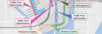
Busan Smart City
|
Key Deliverables
- To scan vehicles and pedestrians using video cameras which are embedded in street lights and vehicle detecting sensors
- To prevent car accident in school zone by giving alarm sign to cars and pedestrians using digital signage and ground LED light devices
- In case of violating stop line, Reporting services to a related government agencies
- To transform street lights into service node by replacing them with LEDs that have control node with various sensors, CCTV and communication modules
|
|
|

|
|
Carolinas Alliance 4 Innovation
|
| The Greenville vision is a multimodal and multi-jurisdictional transportation plan across GPATS from Greenville Spartanburg (GSP) airport through Greenville’s urban areas to Clemson University. The modes include elevated, driverless car transit network system (ATN) aka personal rapid transit (PRT); smarter bus transit (including bus and traffic light sensors and electric buses); connected, assisted, or automated LSEV shuttle services; and more bike and pedestrian-friendly pathways. GreenVillages development will occur around mobility hubs. People live in GreenVillages development and connect at transportation nodes to work, shop, learn, heal and play. Better connectivity for people living along urban corridors helps deal with the issues of first/last mile transport so they would not need to own a car, and reduces traffic congestion, air pollution, transportation costs and traffic accidents.
|
|
|

|
|
Community Traffic Guidance and Control System for Natural Disaster Emergency Response
|
| Integrate city-wide traffic monitoring systems, identify disaster area and automate the traffic control over the zone. Research and develop alternative routes for emergency responders, public safety officials and citizens. Provide real time information on traffic to citizens and city decision makers.
|
|
|
|
|
Connected Vehicle Pilot Security Management Operating Concept
|
| Development of a Security Management Operating Concept (SMOC) for phase I of the Tampa Hillsborough Expressway Authority (THEA) Connected Vehicle (CV) Pilot Deployment Program. This focuses on how the THEA team developed an approach to the SMOC (i.e., Prepare); categorized information flows and systems (i.e., Categorize); and selected security controls to establish draft, minimum security control baselines (i.e., Select). The resulting SMOC is largely based on the NIST RMF and provides guidance for ensuring “the privacy of pilot participants and the overall security of the Vehicle-to-Everything (V2X) system for the THEA CV Pilot.”
|
|
|
|
|
Intelligent Transportation System applications in Kaohsiung City
|
| Create an intelligent traffic monitoring system connected to real-time Traffic Information System to reduce traffic congestion and raise the road safety in the city. Including telecom big data analysis for plan of traffic improvement strategy, congestion prediction and alert, intelligent parking guidance and Cooperative Vehicle-Infrastructure System for intersection safety.
|
|
|
|
|
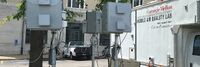
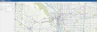
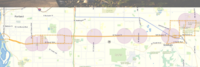
Low-cost Air Quality Monitoring RAMPs in Pittsburgh PA
|
| The proposed project will deploy 30 Real Time, Multi-Pollutant Sensors (RAMPs) at traffic intersections currently managed by the Scalable Urban Traffic Control (SURTRAC) Intelligent Traffic control system, an adaptive traffic control system that optimizes traffic flows in the East Liberty corridor of Pittsburgh (see figure below). These RAMP sensors are portable, low-cost sensors for gaseous air pollutants and particulate matter (PM) that have been developed at Carnegie Mellon and will be mounted on utility poles, using the access already provided by SURTRAC for their equipment.
The existing SURTRAC architecture in East Liberty provides an important platform to study urban air quality through unprecedented approaches that could be replicated across city neighborhoods and which could eventually be scaled across the Pittsburgh metropolitan region. No other system like this currently exists.
|
|
|
|
|
Multi-modal Trip Planner
|
| Develop a tool enables commuters to plan trips encompassing public transit, ride-sharing services, bike rentals, and pedestrian routes. By integrating multiple modes of transportation, this enhanced trip planner aims to make commuting more seamless and convenient, empowering individuals to choose sustainable alternatives to private vehicles.
|
|
|

|
|
NoTraffic Pilot in Redlands CA
|
Key Deliverables
- NoTraffic is developing a solution that enables cities to manage and control traffic based on a network of smart sensors, Vehicle-to-Infrastructure (V2I) communication & real-time optimization of signalized intersections.
- NoTraffic will install the system (4 sensor units and a control unit) at phase one at 1-2 intersections in the city of Redlands CA. Phase one includes collecting data for 2-3 months. Phase 2 will include connecting to the traffic light system and a cloud control panel at the municipality to manage and control the traffic.
- As this pilot program will commerce successfully, the intention is to install the system throughout the whole system.
|
|
|
|
|
Portland Connected Intelligent Transportation
|
| This project focuses on developing a sensor-connected “smart” corridor in Portland where transit data, traffic signalization, and air quality sensing are made available in a data portal with data visualization and analytics to improve transportation options, public health, economic development and civic engagement.
|
|
|
|
|
Regional Infrastructure Accelerator Program
|
| The Pacific NorthWest Economic Region (PNWER) is one of five organizations awarded the U.S. Department of Transportation's Build America Bureau Regional Infrastructure Accelerator (RIA) program grant in its first iteration. PNWER will use grant funds to establish a Regional Infrastructure Accelerator for the Pacific Northwest. The RIA will serve as a convener for transportation projects across the five state member region, specifically multistate and multi-jurisdictional initiatives that are needed, but lack funding for completion.
|
|
|

|
|
Responder to Vehicle Communication for Public Safety - HAAS Alert
|
| Leverage a platform that allows for alerting drivers when first responders are in route nearby. The platform will use existing mobile networks within the city to send the alerts to drivers on their phones and in-dash through our partnerships with automotive companies. The project will assist in moving drivers out of the way of first responders which will ultimately reduce response times, reduce the number of vehicles driving towards an active scene, and look at learnings from analytics and metrics for how long first responders were in lights and sirens mode.
|
|
|
|
|
The Integrated Information Platform for Smart Transportation of Tainan City
|
| After merging Tainan City with Tainan County to be Greater Tainan, the changes in environmental factors such as transportation infrastructure and population increase have made the traffic management work more diverse and arduous. Based on the challenges, a smart system is necessary to enable more accurate and effective decision-making and traffic management. A cross-organized, integrated and IOT value-added systems including intelligent traffic control, smart public transportation, smart parking management, smart vehicle sharing, and smart cloud platform is proposed and developed.
|
|
|

|
|
Using Real-Time Traffic Data to Improve Civic Transportation Services
|
| This project will expand Chapel Hill’s Data program to incorporate Waze real-time traffic data.
Chapel Hill already uses the OpenDataSoft platform to share public data across the town government and with citizens. This project will allow to the town to quickly and seamlessly collect, harmonize and analyze real-time traffic data through the Waze Connected Citizens Program.
The Waze Connected Citizen is a free data exchange program. The OpenDataSoft platform enables the two-way free data exchange between Waze and Chapel Hill and provides tools to analyze the data and compare it with other transportation data already offered by the town.
|
|
|

|
|
West Coast Clean Transit Corridor
|
| The West Coast Clean Transit Corridor Initiative is an ongoing, collaborative effort among 16 utilities to support the development of electric vehicle charging facilities along I-5, from San Diego to British Columbia, for heavy- and medium-duty freight haulers and delivery trucks.
|
|
|
|
|
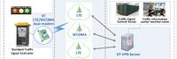
Wireless LTE Traffic Signal Control System Using IoT technology for all crossroads in Gunpo-city South Korea
|
| The Gunpo City traffic signal system was created with a voluntary idea, based on the experience of operating a traffic information system and with the application of the latest IT technology trend.
Thus, we have prepared a stepping stone for the provision of traffic signal information to the private sector in the era of automated vehicles of the 4th Industrial Revolution which had not felt concrete until now.
|
|
|