SandBox: Difference between revisions
No edit summary |
No edit summary |
||
| Line 1: | Line 1: | ||
[[Special:RunQuery:form=Show activity]] | |||
{{#ask: | {{#ask: | ||
[[Category:Activity]] | [[Category:Activity]] | ||
Revision as of 16:21, May 16, 2022
Special:RunQuery:form=Show activity

|
575-HOPE A technology solution to address Preparedness Response and Recovery from opioid and all types of addiction | |
| Integration of available resources and services related to addiction in Hamilton County Ohio in to a program to breakdown data silos, determine best practices, and improve outcomes. This includes a SMS text messaging platform branded “575-HOPE” to engage, inform, and educate those struggling with opioid addictions, and their caretakers. With the capability to proactively inform users that have interacted with the platform of emergency events, the AI-powered and callcenter backed application provides one point-of-entry for those in crisis, ongoing support for those in recovery, and a database of the journey of those individuals accessing services for evaluation by program providers and policy makers. | ||

|
A Perspective towards a New Normality and Working Conditions following COVID-19 | |
| After the first outbreak on COVID-19 in China, the spread to Europe and other continents, the WHO’s pandemic declaration, the already long duration of confinement conditions in some countries and the unknown effects on everybody’s life, we are yet to see the long effects of the pandemic evolution. | ||

|
A Smart Crime-Curbing System | |
| Build a connected, real-time system to help curb crimes in urban areas, integrate real-time response with predictive policing, and standardize procedures for emergency response. Involve city, police, public safety officials, application developers, electrical power board, enterprise center, company lab, and citizens. | ||
|
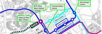
Abuja City Integrated Transportation System | |
| Sustainable Mass Abuja Rapid Transit (SMART) is an easier, efficient and seamless means of utilizing the city’s public mass transit bus service.
Abuja Urban Mass Transit has over 500 buses conveying an estimated 1000 passengers daily. The proposed project will equip 100 buses with devices to generate and transmit real time data and information between drivers, commuters, city transport officials and the general public. The project targets increased ridership and revenue generation from the combination of multiple methods of electronic payments, bus routing, location tracking as well as online bus schedule service. | ||
|
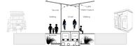
Active Street | |
| The vision to connect the end of the TriMet MAX line in Hillsboro to the Banks-Vernonia State Trail… has been a part of city and regional plans for many years. The section of this trail that runs along an old rail line between Hillsboro and Forrest grove offers some exciting opportunities for this Active Street™ concept. | ||
|
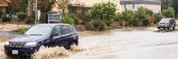
Advanced Flood Warning and Environmental Awareness | |
AFWEAR is a real-time network of environmental sensors, including rain and precipitation sensors that will be located throughout the city of Rohnert Park, a city at the base of Sonoma Mountain in Sonoma County, CA, located 50 miles north of San Francisco with population of 40,000. The purpose of the system will be the following:
| ||

|
Air Quality Monitoring in London | |
Key Deliverables
| ||

|
Air Quality Sensing Wherever You Go in Taipei | |
The proposed project will develop portable AirBox devices to facilitate mobile air quality monitoring, with a focus on PM2.5 sensing, in Taipei city. The device is small-sized and light-weight, and it uses the LoRa technology for low-power and long-range data communication. The expected results of this project are:
| ||
| Amsterdam IoT Living Laboratory and Beacon mile | ||
We provide public networks, open infrastructure and data for developers to accelerate emerging IoT innovations for Smart City solutions
| ||

|
An Open Architecture IoT Platform for a Sustainable Smart City | |
| BEMOSS®-Plus is an open-architecture platform that allows integration of IoT devices for energy savings, security, solar PV and storage in buildings. Its versatility will allow the management of energy usage (e.g., electricity and gas) for the entire city, including traffic and security monitoring. The project involves piloting BEMOSS®-Plus in Arlington County, the City of Alexandria and Virginia Tech university campus. | ||

|
Anatomy of a Smart City | |
| Showing the connecting fiber of a Smart City with Local Government, Public and Private Utilities and Services, Smart Building Technology, Communicating and sharing of Information to residents, business and the community as a whole with emphasis on security throughout the process. | ||

|
Applications and Projects | |
| Mozark Contract Tracing Platform Video deployed by the Department of Telecommunications, Ministry of Communications, Government of India | ||

|
Applying Open Data to inform future Smart City Design | |
In order for cities and design professionals to have a more transparent understanding of the Climate Change impacts of potential building development, they must have a tool that provides quick and facile real time calculation linked to the weather data and utility information of an area, along with the potential energy usage. Between March 2016 and 2017:
| ||

|
Augmented Neighborhood Watch | |
# Engage with Constituents currently part of the City of Oakland NCPCs to keep an eye and report crime to their local police Beat Officers. Present IoT Kits to the NCPCs to invest in micro-grid infrastructure kits that include mesh networks, computer vision cameras, sensors, and secure communication channels to capture live data about events happening to community homes, block by block. Install series of “Capture” hardware devices and send this data to a secure data platform per kit owner.
| ||

|
Availability of Connectivity via WiFi | |
| During the COVID-19 pandemic some local governments and companies have made progress through publishing online and through physical postings to map WiFi Hotspots. | ||

|
Baltimore Community Resilience Hub | |
| Baltimore is highly vulnerable to a range of natural hazards, including coastal storms, flooding, extreme heat, and high winds. These types of extreme events are likely to increase in frequency and magnitude over the coming years. These natural hazards, combined with exacerbated influences of climate change, create impacts that will affect the City’s residents, businesses, infrastructure, and natural systems, and threaten regionally significant assets. | ||

|
Bay Area Unified Wi-Fi Roaming Security and Ease of Use | |
| As more and more cities deploy public Wi-Fi service, security and ease of use are becoming critical. In addition, the service becomes fragmented and constrained by geopolitical boundaries. This action cluster will deploy and evaluate the impact of new Wi-Fi authentication and access management solutions that deliver not only the highest possible end-user security, but will allow participating municipalities to create a unified regional system that users can automatically connect to when in range, regardless of what city/county they are in. | ||

|
Beaverton Electric Bus Pilot | |
| TriMet purchased five electric buses thanks to a federal grant and support from Portland General Electric. These buses will operate on 62-Murray Blvd in Beaverton. | ||

|
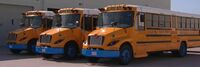
Beverly Public Schools Electric Busses | |
| Beverly Public Schools in Massachusetts has implemented a project utilizing their electric school buses as on-demand power plants. By using bidirectional chargers, the buses' large batteries can both charge and send energy back to the grid, providing backup power during high-demand periods. | ||

|
Big Data and Artificial Intelligence for Road Infrastructure Sustainability | |
| Provide an efficient and effective solution using artificial intelligence and smartphones to monitor and maintain roadway infrastructure with a data-driven approach. Projects at RoadBotics aim to provide better data and identify which roads are failing and which roads need early intervention in order to avoid total reconstruction. | ||

|
BigClouT | |
BigClouT project aims at giving an analytic capability to cities exploiting available big data from sources such as IoT devices, open data, social networks, mobile applications, etc. and use them to improve the daily life of cities, their citizens and visitors. The target applications are:
| ||

|
Blockchain and Public Health | |
| The Action cluster will aim to help collaborate with key stakeholders in the public health community to help create a Guide on best practices, case studies, and standards. The Guide will help guide key decision makers as they begin to formulate their policy positions on Blockchain and Public Health issues. | ||

|
Boring Company Las Vegas Convention Center Loop | |
| The LVCC Loop system — a three-station transportation system consisting of 1.7 miles of tunnel — was built in approximately one year (using the now-legacy Godot Tunnel Boring Machine). LVCC Loop's cost was approximately $47M (firm fixed pricing) for the two tunnels and three stations (two surface and one subsurface). Tunneling occurred during large conventions (>100,000 attendees pre-COVID) with zero road closures and zero attendee disturbances. | ||

|
Breaking the Code The UN-hackathon | |
| Multnomah County, Oregon is partnering with Technology Association of Oregon (TAO) and other local groups to host a community collaborative problem solving event and an ongoing, community-based technology incubator called Breaking the Code.
We aim to break some of the barriers that exist among organizations that specifically serve people of color and the broad, local tech community. Partnering together gives us a platform to bridge the gap between the two and provide opportunities for Community Based Organizations (CBO’s) to become more efficient and effective in their targeted service delivery. A longer term goal is the creation of community-based and community-led technology start-ups. Breaking the Code’s framework leverages assets from the public sector (data, staff, technology platforms, public infrastructure, small business incubation, etc.), and the technology industry (technology solutions, expertise, professionals, funding, etc.) with the goal of making CBOs more successful serving their community. This, in turn, fulfils the promise of smart cities as “thriving communities” with well being across the life span, equity and access, sustainability, resiliency, and vibrant arts and culture. | ||

|
Building Human Centered Smart City | |
To deliver:
| ||

|
Building an Open Data Ecosystem | |
| The "Building an Open Data Ecosystem" project in Leeds, United Kingdom aims to foster collaboration and innovation through the development of an open data ecosystem in the city. | ||

|
Busan Smart City | |
Key Deliverables
| ||

|
Business response to Community Disease Transmission | |
| Information and guidance from trustworthy sources to help businesses rapidly and cost-effectively protect their employees, customers, and partners from the risks of exposure to communicable diseases such as COVID-19. | ||
|
CITYDASH City-wide analytics dashboard from public and private data sources | |
Data analytics and insights powered by machine intelligence for 4 target city departments:
| ||
|
CIVIC Data Platform | |
| CIVIC is an open data platform to democratize
public information and drive meaningful engagement through neutral, nonpartisan analytics. It's built entirely by multidisciplinary teams of volunteer coders, designers and domain experts using open source technology. | ||

|
CIVIC school HUBS | |
| NSF CIVIC grant to incubate the Federal School Infrastructure Toolkit for more resilience Community services. A pilot program with be developed with the BENSON school district in Portland, and woven into the urban/rural network of the Metro regional emergency response. | ||

|
COVID Calculator | |
| The COVID Calculator determines whether you’ll quarantine or isolate, and for how long. | ||

|
COVID-19 Checklist for EMS Agencies by NASEMSO and NPSTC | |
| This checklist represents an ongoing analysis of COVID-19 preparation actions by the Joint Working Group on EMS Communications and Technology which is sponsored by NASEMSO and NPSTC. It is designed to provide guidance to EMS agencies as they plan their response to the COVID-19 pandemic. | ||

|
COWs COLTs Aerostats for Emergency Distance Learning and Telemedicine Broadband Connectivity in Rural Areas | |
| This white paper describes COWs (Cell-on-Wheels), COLTs (Cell-on-Light Trucks), and Aerostats (CCAs) used to provide cellular or Wi-Fi connectivity in areas without 4G. They are used to provide emergency communications during catastrophic events such as fighting forest fires in rural areas, and in aftermath of earthquakes, hurricanes, or floods. In California there have been a series of state-level broadband meetings focused on the need to provide an immediate response to fill the distance learning and telemedicine broadband access gaps to unserved rural households sheltering in place during the COVID-19 crisis. Some telecommunications providers and public libraries are offering free Wi-Fi hotspots with 4G service to take home; however, 4G hotspots only work in areas with cellular broadband service. | ||
|
Cajon Valley Union School District Electric Bus System | |
| San Diego Gas & Electric Cajon Valley Union School District Electric Bus System tests the technology that enables eight electric school buses to put electricity back on the grid when needed such as on hot summer days. A collaborative effort between SDG&E, the Cajon Valley Union School District and locally based technology company Nuvve, this is the first vehicle-to-grid (V2G) project to become operational in Southern California, helping to advance clean air and climate goals while also bolstering grid reliability. | ||
|
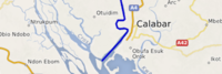
Calabar IoT-based Smart Waste Project | |
Objectives
| ||

|
Campus Array Node and Array of Things Network Dual Deployment | |
| The Project entails the dual deployment of Argonne National Labs’ Array of Things (AoT, v.2) and Georgia Tech Research Institute’s Campus Array Node (CAN, v.1). In combination, these two sensor networks will aid multi-modal transit from the perspective of both operators and users.
Partnering with the City of Atlanta, Georgia Tech Research Institute, and Argonne National Labs, and focusing on issues related to multi-modal transit, the Project focuses on the on-the-ground interoperation of two Internet of Things systems—AoT focused on environmental sensing and CAN focused on traffic/public safety monitoring—and how to display real-time data for public transit operators, pedestrians, and officials in meaningful ways that inform efficient, effective, and comfortable use of various mobility options. From the engineering and infrastructural considerations to the political and community issues, the Project is a case study of a cyber-physical system that will result in a model of how to proceed with issues of interoperable Internet of Things systems, from technical standards to community engagement to areas of future work. | ||

|
Carolinas Alliance 4 Innovation | |
| The Greenville vision is a multimodal and multi-jurisdictional transportation plan across GPATS from Greenville Spartanburg (GSP) airport through Greenville’s urban areas to Clemson University. The modes include elevated, driverless car transit network system (ATN) aka personal rapid transit (PRT); smarter bus transit (including bus and traffic light sensors and electric buses); connected, assisted, or automated LSEV shuttle services; and more bike and pedestrian-friendly pathways. GreenVillages development will occur around mobility hubs. People live in GreenVillages development and connect at transportation nodes to work, shop, learn, heal and play. Better connectivity for people living along urban corridors helps deal with the issues of first/last mile transport so they would not need to own a car, and reduces traffic congestion, air pollution, transportation costs and traffic accidents. | ||

|
Cascadia Innovation Corridor | |
Municipal, academic, corporate and federal smart city activities are being coordinated across Portland, Seattle and Vancouver BC through the integration of several regional initiatives:
| ||

|
Central Data Management System | |
| The 'Central Data Management System' project in Vienna, Austria aims to establish a comprehensive and efficient data management framework for the city. Led by the City of Vienna's Department of Data Management, the project seeks to centralize data storage, ensure data quality and security, and streamline data access and sharing processes. | ||

|
Chula Vista Smart Waterfront | |
| The Chula Vista smart waterfront is a 535 acre joint development by City of Chula Vista and the Port of San Diego – currently the largest waterfront development project on the U.S. West Coast. The development is groundbreaking in its approach to energy efficiency in (1) targeting 50 percent reduction in annual energy use for the development and (2) each building performing at least 15 percent better than Title 24 requirements in the California Building Energy Efficiency Standards. Recognizing the need to monitor and control this new energy infrastructure, the Bayfront project also focuses on the communications network technologies and smart infrastructure solutions that will provide operational efficiency, sustainability, and economic development opportunities for the City. The Project team, led by Black & Veatch, is focused on evaluating the three major components of energy, telecom, and smart infrastructure – determining solutions that will meet the aggressive energy goals and provide a foundational, scalable approach to future communications and smart city applications. | ||
| Cincinnati-Dayton Cyber Corridor | ||
| A regional consortia approach to cybersecurity education and workforce readiness was formed by Southwestern Ohio Council for Higher Education (SOCHE) in cooperation with the Air Force Institute of Technology, the Dayton Development Coalition, University of Cincinnati, University of Dayton, and Wright State University. The coalition has expanded over time to other higher education, K-12 and industry partners. The consortium’s mission is to serve as a resource for education, research and workforce development in cybersecurity and information assurance. | ||

|
Citizen App | |
| Citizen App, the first of its kind, empower individuals to claim and legally own their data from across multiple sources, then use it securely and seamlessly in everyday life. | ||
|
City Insight Platform- Communities in Context | |
| Using data from the city, state and federal level Vizalytics will create a City Insight Platform.
This will provide users with a real-time view of what is happening in a neighborhood, and can be refined by choosing which lens to view- from socio-economic indices, business climate, transportation, infrastructure, quality of life and more. | ||
|
City of Boston GoHubs | |
| A majority of our residents rely upon public transit, biking, walking, and driving to get around our city. But, shared mobility and technology advances are altering travel. New ways of transportation are introduced each day. The future of transportation may very well be shared, electric, and highly mobile. GoHubs! are intended to help us organize these modes. We provide information on how to access them and navigate the technology, and ultimately make it easier to get around Boston | ||

|
City of San Leandro, CA: “SL Wi-Fiber” | |
| Since the creation of Lit San Leandro – a public-private partnership that yielded an 18mile, fiber optic loop – installing a free, Public Wi-Fi system in the city’s downtown core had been one of the City Council’s long-standing goals. | ||

|
City of Schenectady, NY: Enhanced City Services | |
| As part of Schenectady’s Lower Union Street reconstruction Project that started in late 2015, Smart Lights have recently been installed that allow the control of lighting and other sensors to monitor devices as well as provide a small scale Public Wi-Fi deployment. This deployment, activated on June 20th 2017 as Schenectady’s contribution to World Wi-Fi Day 41 , gives residents, and visitors within a 5-block area of State Street (from Broadway to Lafayette) access to the internet and is helping to identify value for further Wi-Fi deployment. 42 Wi-Fi access points also allow the city to control smart lighting and other IoT sensors that help in evaluating the benefits of various accessories. This project is in coordination with additional Wi-Fi access in front of City Hall on Jay Street that is also available for residents and visitors to the city. | ||

|
Clarity Amidst Chaos – How AI is Enhancing Emergency Preparedness | |
| SF Bay area Emergency Managers and One Concern have joined together to provide the power of AI to California emergency responders.
‘Seismic Concern’ uses artificial intelligence and state of art earthquake engineering research to provide emergency managers with damage maps and statistics in the immediate aftermath of a catastrophic earthquake, enhancing situational awareness required for rescue and relief efforts. Moreover, through the ‘Seismic Concern Training Module’, emergency operations centers will be able to design and train on realistic scenarios based on actual simulations to get a real sense of the situation. One Concern will demonstrate their capability to predict the extent of damage to personal residences, commercial and government building as well as other critical infrastructure in the immediate aftermath of an earthquake in the San Francisco Bay Area Region, as well as the capability of the training/simulation module to aid resiliency and mitigation efforts. SF DEM will demonstrate how One Concern’s technology will enhance immediate response and recovery efforts and will use their simulations to quantify mitigation efforts and develop accurate scenarios for emergency responders. | ||

|
Combating Urban Blight in the New York Capital Region and Mohawk Valley | |
| Urban blight is a city and regional level problem that impacts social and economic opportunities, among others, of those who live and work in cities. This project is focused on piloting a shared policy, management, and technology infrastructure that will allow four cities within the NYS capital region to share information about properties in a way that enables new insights into and action focused on urban blight. With funding from the NYS Department of State, the Cities of Schenectady, Troy, Amsterdam, and Gloversville have partnered with the Center for Technology in Government (CTG), University at Albany, to develop the technical, policy, and organizational capabilities needed within and across the cities to interrupt the cycle of blight in their communities. The results of the pilot will be made available for application regionally and statewide. Future work will include integrating additional data types (e.g. video) and sources (e.g. sensor technologies). | ||

|
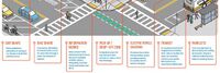
Community Traffic Guidance and Control System for Natural Disaster Emergency Response | |
| Integrate city-wide traffic monitoring systems, identify disaster area and automate the traffic control over the zone. Research and develop alternative routes for emergency responders, public safety officials and citizens. Provide real time information on traffic to citizens and city decision makers. | ||
... further resultsThe part "]]" of the query was not understood.</br>Results might not be as expected.