Advanced Flood Warning and Environmental Awareness
| Advanced Flood Warning and Environmental Awareness | |
|---|---|

| |
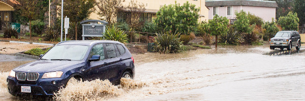
 Bay Area storm in Rohnert Park | |
| Team Organizations | Dew Mobility Sonoma County Water Agency Center for Environmental Inquiry Sonoma State University Engineering Science Department Sonoma State University Facilities |
| Team Leaders | Shivakumar Mathapathi |
| Participating Municipalities | Rohnert Park CA Santa Rosa CA Sonoma County CA |
| Status | Launched |
| Document | 
|
Description
AFWEAR is a real-time network of environmental sensors, including rain and precipitation sensors that will be located throughout the city of Rohnert Park, a city at the base of Sonoma Mountain in Sonoma County, CA, located 50 miles north of San Francisco with population of 40,000. The purpose of the system will be the following:
- Improve flood response time and efficiency throughout the city.
- Link rainfall observations in the upper watershed (on the hill) and coasts to predictions of stream flow in the city.
- Provide ability to incorporate various environmental sensors, watershed models (assessment tools to plan and manage watersheds), and user-friendly communication tools into the network to allow for rapid understanding and collaboration between scientists, citizens, and city planners as necessary in response to environmental “events”.
Challenges
- Ensuring data accuracy reported by sensors form monitoring nodes and conducting routine on-site sensor calibration (manual or automatic).
- Creating a reliable & automatic alerting system to notify city staff members and citizens while ensuring the messages have been received.
- Establishing a user-friendly climate database with easy to understand data visualization features for citizens as well as the scientific community.
- Providing continuous off-grid energy for remote monitoring stations deployed at the upper watershed.
- Scalability for entire Sonoma County to install multiple sensor networks and communication links to the server/Bluemix environment.
- Assess the Intel platform to accept various inputs for flood warning and environmental sensors. If needed parallel Intel Arduino board to be connected. Prototype to be created.
Solutions
TBD
Major Requirements
Pre-Evaluation :
- Feasibility study for porting existing Raspberry Pi based AFWEAR to Intel Arduino 101 platform.
- Feasibility study to migrate existing remote server configuration to IBM Bluemix environment.
- Identify the requisite sensors for effective and reliability working system for new technology environment such as Intel Arduino and Bluemix.
- Effective Integration of other environmental sensors such as: CO2, Temperature, Humidity, Air quality, Barometer, Gas and Light sensors.
Post evaluation, following core steps shall be implemented.
- Design a real-time remote monitoring station (node) to measure the water flow & precipitation using robust and accurate off-shelf sensors.
- Deploy reliable communication links using 3G Cellular, Wi-Fi, and Satellite technologies for data collection form remote stations.
- Provide data visualization of the reported rainfall totals and watershed (or river basin) sizes on interactive online maps and accurately develop models to link them to potential flood watch warning messages for public and city authorities.
- Establish robust and reliable communication links (via Cellular technologies) for alerting potentially impacted communities (flood clear, flood watch, flood warning, etc.)
- Create cloud-based interactive mobile and web applications, as well as web-based data analytics where both the public and scientist communities can refer for historical environmental data throughout the city.
- Enhance system capability such that other scientists can install their own approved environmental sensors (e.g., camera, CO2, water quality) to AFWEAR.
Performance Targets
| Key Performance Indicators (KPIs) | Measurement Methods |
|---|---|
|
|
Standards, Replicability, Scalability, and Sustainability
A key concept in design and deployment of AFWEAR is to utilize available open-standards, including: Using available high-performance, low-power, low-cost general-purpose development module (e.g., Intel Arduino 101) that can be interfaced with existing off-shelf industry standard sensors and communication devices (e.g., Wi-Fi for GSM modules).
- Utilizing industry standard communication technologies such as Wi-Fi 3G/4G Cellular and Satellite technologies for data transmissions and collection.
- Incorporating an open-cloud, open-source, secure development platform (such as IBM Blue mix/ AWS /ARTIK) to develop interactive web and mobile applications and high-performance data analytics.
- Comply with MQTT and CoAP IoT Protocol for effective communication from sensor data to the server. Such interoperability allows user to access the real time data on any desktop or mobile devices.
Replicability
Using open-source hardware and software platforms, and off-shelf standard industry sensors, as well as incorporating standard communication protocols we ensure the system design is fully replicable. A key design issue is to ensure that the network performance is scalable both vertically and horizontally. The vertical scalability (expanding the network reach) will be ensured through using standard communication links. Furthermore, through utilizing IBM Bluemix, we ensure availability of a high-performance data center where large number of users can access large set of monitoring nodes. The horizontal scalability (expanding node features) will be ensured through using open-source, low-cost hardware and on-board standard communication protocols such as I2C and SPI. Drafting a clear maintenance plan funded by the city of Rohnert Park will ensure sustainability of the network. Such plan will include participation of city authorities and Sonoma State University community (e.g., faculty and students). Furthermore, to achieve continuous flood monitoring, the network is required to have reliable power source and backup battery.
Cybersecurity and Privacy
The AFWEAR system Ver 3.0 shall be designed to address cybersecurity and privacy as per details proposed below:
- Add security software components to the cloud platform
- Utilize device certification offered by cloud vendors for instance AWS, IBM Bluemix and Microsoft Azure
- Add Encryption software/firmware to the end points such as sensors, actuators and MCU.
- Analyze the vulnerability and threats, and address by designing customized security model.
Impacts
Using the AFWEAR it is possible to increase mitigation time yielding benefits in various areas including:
- Reducing property damage: allowing residents to remove property, including TV, electronic appliances, vehicles, etc.
- Increasing public safely: closing a shut-off valve on a gas line, halting discharge of certain materials into the sewage system, or safeguarding water supplies and sewage treatment plants.
- Conducting timely traffic control: traffic can be re-routed in a more efficient manner and personnel can be deployed in a timely manner to block access to potentially dangerous areas as well as to direct traffic on detour routes.
- Manage disaster risk plans
Demonstration/Deployment
Phase I Pilot/Demonstration June 2016:
- Evaluate the present Raspberry Pi and remote monitoring server. Re- architect to port for utilizing Intel Arduino IoT platform and Bluemix cloud services.
- Deploy one fully operational off-grid solar-powered environmental monitoring station (node) that consists of off-shelf sensors and a development board (Intel Arduino 101), at the upper watershed in Fairfield Osborn Preserve (5 miles north of Sonoma State University). In this phase we also interface the monitoring station to a prototype server located at the University to ensure reliable rainfall and watershed size measurements and test stability of the communication links.
Phase II Deployment June 2017:
- Deploy four monitoring nodes throughout the city of Rohnert Park. The nodes will be fully capable of providing flood warning information (e.g., flood clear, flood watch, flood warning, etc.). In this phase, we also utilize IBM Bluemix and its data analytics features to perform flood forecast. Furthermore, in this phase we expand the design of each monitoring node such that each node can support integration of other environmental sensors, such as temperature, water quality, CO2, etc., around the city.
Phase III 2018: