Semantic search
Jump to navigation
Jump to search

|
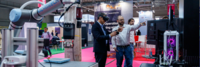
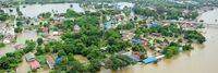
[[Community Traffic Guidance and Control System for Natural Disaster Emergency Response]] | |
| Integrate city-wide traffic monitoring systems, identify disaster area and automate the traffic control over the zone. Research and develop alternative routes for emergency responders, public safety officials and citizens. Provide real time information on traffic to citizens and city decision makers. | ||
|
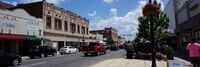
[[Complete Neighborhoods — Building a Healthy Connected City]] | |
| The goal of the Healthy Connected Neighbourhood Strategy is to bring complete neighbourhoods to 80% of the city’s population by 2035. The Strategy is integrated into the main Portland Plan, a comprehensive strategic plan to achieve urban equity and sustainability. | ||
|
[[Connected Vehicle Pilot Security Management Operating Concept]] | |
| Development of a Security Management Operating Concept (SMOC) for phase I of the Tampa Hillsborough Expressway Authority (THEA) Connected Vehicle (CV) Pilot Deployment Program. This focuses on how the THEA team developed an approach to the SMOC (i.e., Prepare); categorized information flows and systems (i.e., Categorize); and selected security controls to establish draft, minimum security control baselines (i.e., Select). The resulting SMOC is largely based on the NIST RMF and provides guidance for ensuring “the privacy of pilot participants and the overall security of the Vehicle-to-Everything (V2X) system for the THEA CV Pilot.” | ||

|
[[Connecting Communities with Public Wi-Fi technology and local Tourism mobile applications]] | |
| Provide areas of Public Wi-Fi for use by residents, employees and visitors while deploying informational mobile application showcasing local businesses and giving real time data for local trolley schedules.
Using technology to collect data which will improve the operation of local governments. | ||
|
[[Connecting Rural School Children for Distance Learning]] | |
| As the SARS-COV-2 virus spreads, and communities work to minimize COVID-19 cases, schools are closing and we expect all school physical facilities will remain closed for some period of time during this emergency. This will affect more than 76 million students across the US. | ||

|
[[Connecting the Dots Technology Enhanced Aging-in-Place for Residents of Waterfront Village]] | |
The Objectives of this project are:
| ||
|
[[Constituent-led Public Data and IoT Utility for Urban Health Housing and Environmental Hazard Management]] | |
Objectives
| ||

|
[[Coral Gables Smart City Hub Public Platform]] | |
| The City of Coral Gables promotes the development of a smart city ecosystem that fosters innovation by bringing together through technology People, Businesses, Organizations, Things, and Systems. By leveraging strategic planning and innovation, the City’s digital transformation and smart initiatives can benefit our citizens with continual improvement to customer service and quality of life. Our smart city plan implements several interconnected and interoperable elements that include a Smart City Hub, Data Platforms, Internet of Things, and a robust and resilient technology infrastructure with high-speed communications. | ||

|
[[CoronaVirus Research Opportunities]] | |
| CoronaVirus Research Opportunities List | ||
|
[[CryptoMove San Leandro Smart Lights Project]] | |
| Create reference architecture for Smart Lights and Sensors via deployment of CryptoMove Moving Target Data Protection to render data onto a constantly shifting and mutating defensive fabric, thereby greatly decreasing the likelihood of exfiltration of sensitive data, and likewise for ransomware probability. | ||

|
[[CyberCity Education Platform]] | |
# Expand upon an existing NSF CICI grant at GW to extend regional access to the Michigan Cyber Range over CAAREN (100 Gbps DWDM network interconnected with Internet2) and develop enhanced real-world training environments using an advanced software defined multi-service exchange (MSX) technology.
| ||

|
[[Cybersecurity Risk Assessment and Mitigation]] | |
| Empower municipalities with cybersecurity risk assessment methodology and resources to enable timely understanding of their risk levels and appropriate mitigation against cyberrisks.
The risk assessment methodology is adapted from NIST Cybersecurity Framework with a Technical Risk Rating component and an Expert Assessment. The daunting resource shortage is addressed by a unique volunteer matching mechanism based on public-private partnerships. | ||

|
[[Cybersecurity and Privacy Resilience Center]] | |
| COVID-19 crisis has amplified Cybersecurity & Privacy Risks for organizations with their transition to remote and virtual work arrangements. These risks range across infrastructure, data security, data privacy, remote access, policies, security awareness and compliance. | ||

|
[[DC Asset Management Lab at the University of the District of Columbia]] | |
| DC Government desires dramatic benefits through the use of the ISO 55000 management system for asset management and asset visualization tools and processes piloted through the U.S. Federal Government. The Lab allows a series of DC Government problems to be addressed in a 4-week workshop requiring 20 total hours that points to publicly available solution sets that can be deployed by DC or any other municipality that sends students to courses. | ||
|
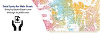
[[Data Equity for Main Street - Bring Open Data to Communities through Public Libraries]] | |
| The Data Equity for Main Street Project is a Data Literacy and Civic Tech project that has aimed to engage community members in open data and empower them to participate in open data projects. By engaging in a curriculum that is meant for those who want to learn about and give feedback on open data, rather than just publish open data, participants improve their digital (data) literacy skills and be exposed to opportunities to use open data to inform community issues or answer individual questions. The project is moving into a new phase, from a in-class online model, to an online, interactive model. We seek to identify the impact of this new online, interactive model. | ||
| [[Data.gov]] | ||
| Data.gov is a website operated by the U.S. federal government that provides access to datasets and other resources related to government activities and policies. It is intended to make government data more easily accessible to the public, with the goal of increasing transparency and enabling citizens to better understand and engage with their government. Data.gov offers a wide variety of data sets and resources, including data on topics such as agriculture, education, energy, finance, health, and more. The website also includes tools and resources for developers, such as APIs and code libraries, to help people use the data in creative and innovative ways. | ||
|
[[Dealing with Shortages of Critical Equipment]] | |
| As the number of COVID-19 cases from the SARS-COV-2 pandemic continues to grow, communities are encouraging physical (or “social”) distancing to slow the rate of transmission. The goal of this guidance is to flatten the curve of new infection, avoiding a surge of demand on the health care system The effects of physical distancing may take several weeks to take effect. Hospitals are already reporting shortages of key equipment for critically ill patients, including ventilators and personal protective equipment for medical staff. Adequate production and distribution of both types of equipment are crucial to caring for patients during the pandemic. | ||

|
[[Decision Theatre PSU]] | |
| Portland State University’s Decision Theater is designed for university researchers and regional stakeholders (i.e. government, private companies) to work on projects that “link data sets, visualization and decisions,” according to a university statement. The space is modeled after Arizona State University's Decision Theater, as well as a similar facility at the University of Chicago. | ||
|
[[Deployable Communications and Incident Command System for Emergency Response and Disaster Recovery]] | |
| The integrated system will facilitate communications and information sharing during disaster recovery. It can be deployed in area where communications do not exist or failed due to disasters. The system will include (1) A Deployable Communication System, (2) Onboard Sensors (3) Next Generation Incident Command System and (4) Web Services | ||
|
[[Deployment of user-friendly, secure and sustainable federated public Wi-Fi systems]] | |
| To deploy a sustainable federated public Wi-Fi solution across Singapore that is has easy to use secure authenticated access and jointly develop a set of best practices with cities, industry players, and the academia to promote coordinated public Wi-Fi deployment, to address signal interference issues, standardizing user experience and security. | ||

|
[[DigiTel Resident Card]] | |
| The City of Tel Aviv has undergone a transformation to become a “smart city” that uses technology to improve the City Hall administration and its citizens’ lives. Through programs such as the DigiTel Residents Club and the DigiTel mobile application, Tel Aviv offers innovative electronic services to its population and is searching ways to make citizens interested in how the city works. Throughout the process, Tel Aviv has worked closely with Microsoft to find the best ways to achieve its vision of a smart city. | ||
|
[[Digital Strategy Borchen-Etteln]] | |
| To further increase the quality of life for all people in Borchen-Etteln and to develop the economic, social and ecological potential. In doing so, we take into account the interests of all age groups | ||

|
[[Digital Twin: Buildings As Batteries]] | |
| An innovative approach to digital twins that enables decentralization of power grids at unprecedented speed and scale. | ||
|
[[Digital Twin: Emergency Communication Services]] | |
| Establishes a practical approach for management of emergency and incident response with a common operating picture. | ||
|
[[Digital Twin: Infectious Disease Management]] | |
| Link time, spatial and sensor data with existing enterprise data to enable new insights. | ||
|
[[Digital Twin: Manufacturing Quality Control Via Remote Operator]] | |
| The post-Covid world necessitates remote verification of manufacturing components – in real-time, as they are conveyed across the manufacturing line. | ||
|
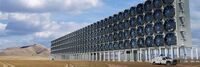
[[Direct Air Capture Plant in Oregon]] | |
| 280 Earth, Inc. has launched its inaugural Direct Air Capture (DAC) facility in The Dalles, Oregon, marking a significant milestone in the fight against climate change. | ||

|
[[Dwellingly]] | |
| Dwelling.ly is an app to improve communication between the landlord providing transitional housing and the social workers who support them. | ||

|
[[ECommerce and Payment Business Tools]] | |
| During this difficult time of change and disruption, entrepreneurs and businesses need to easily and rapidly launch new or scale promising businesses, while optimizing cash flow, staff, and operations. | ||

|
[[East Palo Alto Neighborhood Innovation Zone]] | |
Objectives
| ||
|
[[East Portland Resilient Island Vision Plan]] | |
| To execute the East Portland Resilient Island Project, RIP City Planning has partnered with Portland’s Disaster Resilience and Recovery Action Group (DRRAG), an organization composed of representatives from Portland Bureaus of Development Services, Emergency Management, Environmental Services, Water, Planning and Sustainability, Transportation, and Parks & Recreation, as well as Portland State University’s Institute for Sustainable Solutions. | ||
|
[[Eastside Crescent Transportation Alliance]] | |
| The Eastside Crescent Transportation Alliance provides a governance structure for a transportation management Alliance. The Alliance lines coordinates public funding for projects like I405, Sound Transit, curved space, and traffic light coordination. It would provide the employer connection to those efforts in the Bothell geographic area from its life sciences community to SeaTac airport. | ||
|
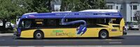
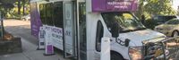
[[EcoMotion: Electrifying Washington Park's Circulator for a Greener Future]] | |
| This project converts five existing Ford transit buses to electric power. This conversion not
only reduces cost over buying new it ensures the gasoline engine is removed from the road and recycled instead of being sold for another use. It also retains the chassis and other equipment saving emissions over a new purchase. | ||
|
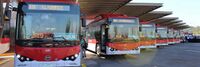
[[Electric Bus Deployments in Santiago de Chile]] | |
| An electric bus implementation program in Santiago, Chile, inspired by the buses in Bogotá, Colombia, began in 2014 through a partnership between the Chilean Ministry of Transport and two privately held companies, Enel X and BYD, an Italian electric company and a Chinese bus making manufacturer, respectively. | ||

|
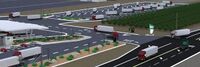
[[Electric Island]] | |
| Electric Island is located across the street from DTNA headquarters, less than one mile from I-5, and represents the first location specifically designed for medium- and heavy-duty trucks aligned to the blueprint of the West Coast Clean Transit Corridor Initiative (WCCTCI). WCCTCI’s collaboration between nine electric utilities and two government agencies yielded a strategic plan in 2020 to electrify 1,300 miles of I-5 across the three West Coast states to provide publicly available charging for freight and delivery trucks. | ||

|
[[Electric Mobility Hub Demonstration]] | |
| An inviting & equitable community space that showcases electric mobility, integrates the street to the neighborhood, and serves as a model for future hubs. | ||
|
[[Electric Mobility Lab]] | |
| The EMS the Phase 0 Launch for the electric mobility initiative at Marine Corp Air Station Miramar. It included dynamic presentations from key government leaders on changing policies and plans, interactive panels with electric mobility thought leaders, as well as immersive demonstrations and discussions of technologies with industry-leading organizations. | ||
|
[[Electric Truck Charging Depot in Salem]] | |
| WattEV is planning to build an electric truck charging depot in Salem, Oregon, off Interstate 5, with the capacity to power approximately 40,000 trucks annually. | ||
|
[[Emergency Communication Services]] | |
| Establishes a practical approach for management of emergency and incident response with a common operating picture. | ||
|
[[Empowering Ruston City Services Using Wireless Sensor Networks]] | |
| The City of Ruston, Louisiana has a number of ongoing projects to improve the quality of life for its residents, including a Smart Grid system and a downtown fiber optic network. Louisiana Tech University plans to develop low-cost improvements to city services using the fiber-topic and small cell installations to enable smart transportation, smart weather, and smart flood risk monitoring and notification capabilities that can be viewed via a Smartphone App. We also plan to study the use of smart re-closers, wireless connectivity, and solar power potential. | ||

|
[[Empowering walkable and bikeable communities using smart Decision Support System integrated with Vehicle-to-Everything communication]] | |
| WIOMAX has developed a smart Decision Support System (DSS) integrated with Vehicle-to-Everything (V2X) for better road safety and increased urban mobility. The main purpose of this project is to apply the smart transportation solution and incorporate pedestrians and cyclists as beneficiaries of the innovative technology, for empowering walkable and bikeable communities through enhancing road safety, sustainability and smartness of cities. | ||
|
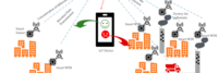
[[Environmental Sensing Across the Metro DC Region]] | |
| Create a network of environmental sensors placed on campuses throughout Washington DC that are participating in the DC MetroLab partnership. This effort will enable public access to environmental data like temperature, wind, gas and particulate concentration, and even traffic flows, simultaneously from all over the city. Involves city technology, planning, and networking agencies and MetroLab partners; George Washington, Georgetown, American, Howard and The District of Columbia Universities. | ||

|
[[EnvyPorto]] | |
| Through small and low cost sensing stations that can be installed in the urban infrastructure, it is possible to create a dynamic high level map of indicators on air quality, noise pollution levels, temperature, atmospheric pressure, humidity and luminosity. Using this high level map in articulation with the data collected using a small number of certified sensing stations (usually high-cost stations), cities will be able to define dynamic urban policies, namely on mobility and energy. | ||

|
[[Equity in Cybersecurity Training - A New Collaborative Pilot in Chicago]] | |
| AnitaB.org and ISACA (the Information Systems Audit and Control Association), under the support of the Connect Chicago program, aim to create an accessible cybersecurity training program that can help close the skills gap. Out team will offer training and workforce opportunities for women in underrepresented communities in Chicago. Our program will take them through skills training in a cohort environment with mentorship, role models, and career advancement available. This pilot program is supported by the Connect Chicago Innovation Program, a fund managed by the City Tech Collaborative in partnership with philanthropy, industry, and the City of Chicago. | ||

|
[[Estimation of De Facto Population]] | |
Key Deliverables
| ||
|
[[Eton College Energy Station]] | |
| The installation of an innovative renewable "Energy Station" is helping GRAHAM to reduce its carbon footprint and power demands at Eton College. | ||

|
[[Family CARE - Caregiver 2.0]] | |
| Presence Caregiver learns daily activity patterns and can warn caregivers, family members and friends about incidents of concern with text alerts of potential hazards including falls, water leaks and wandering. | ||
|
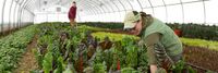
[[Farm to Fork Crop Tracking]] | |
| Tracking a berry crop at the box, bin, or tote level from harvest in the field to end user. Monitor in near real time temperature, humidity, shock and other environmental conditions to ensure product quality after harvest, throughout transit and during storage. Potential to use blockchain to ensure authenticity of food safety certification which can travel with each sensor. | ||

|
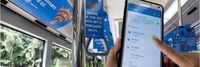
[[Fast Wi-Fi boost for Copr Bay]] | |
| Fast and reliable Wi-Fi technology is being introduced in Swansea's emerging new Copr Bay district, letting thousands of people stream content at the same time to their mobile devices. | ||
|
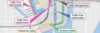
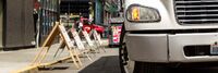
[[Final 50 Feet: Urban Goods Delivery System]] | |
| The Final 50 Feet program looks at methods to improve delivery at the end of the supply chain, such as loading areas, traffic control and street design. We will pilot low-cost and high-value actions to optimize operations of goods. This will help us understand, maintain and enhance safer and efficient deliveries throughout a city and region. | ||