Semantic search
Jump to navigation
Jump to search

|
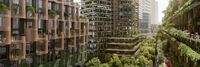
[[Kashiwanoha Smart City Project]] | |
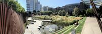
| The Kashiwanoha smart city project (first described as Kashiwanoha International Campus Town Initiative) is a planned from scratch city project, involving a greenfield smart city vision, situated around Kashiwanoha Campus Station. Kashiwonoha smart city project is a privately-led project, with Mitsui Fudosan as the main developer. It was also the owner the previous owner of the golf course on which construction work of the project were first based. However, Kashiwa city was designated as one of the "FutureCities" by the national government in 2011, making Kashiwanoha new town project eligible for government subsidies. | ||

|
[[Lutece]] | |
| Lutece is an open source platform developed by the City of Paris to help you develop digital solutions. Honed for cities’ use through almost 20 years of development, Lutece has evolved into multifaceted platform with more than 400 plugins and modular architecture that will enable your specific needs and enhance your users' digital experience. | ||
|
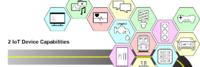
[[Managing Cybersecurity and Privacy Risk for Smart Public Safety IoT Devices and Systems]] | |
| This use case provides a notional approach to address cybersecurity and privacy risks related to incorporating IoT in smart public safety applications. This use case posits some of the major activities, key stakeholders, and potential resources for each step of the cybersecurity and privacy risk management process. | ||
|
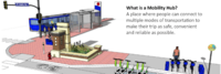
[[Minneapolis Mobility Hubs]] | |
| In 2019, the City of Minneapolis launched a mobility hub pilot program to increase access to convenient, low or no carbon transportation options, including transit, shared scooters and Nice Ride bicycles. | ||

|
[[Move PGH]] | |
| Move PGH unites diverse mobility services and created to provide Pittsburghers with more choices to get everywhere you need and want to go. Think of it as your one-stop-shop for all your transportation needs in the City of Pittsburgh. In coordination with the Department of Mobility and Infrastructure (DOMI) and powered by a group of the city's premiere mobility operators dubbed the Pittsburgh Mobility Collective, Move PGH will create a streamlined and accessible experience for car-free urban mobility. | ||
|
[[Multi-modal Trip Planner]] | |
| Develop a tool enables commuters to plan trips encompassing public transit, ride-sharing services, bike rentals, and pedestrian routes. By integrating multiple modes of transportation, this enhanced trip planner aims to make commuting more seamless and convenient, empowering individuals to choose sustainable alternatives to private vehicles. | ||

|
[[My Digital Data Locker Baltimore]] | |
| For those staying in a shelter or shuttling between other people’s homes, keeping track of these vital documents can be near impossible. They also can be lost, destroyed or stolen.
Recognizing that this was blocking some people from securing stable housing, the city of Baltimore this year launched an innovative program — My Digital Data Locker — to help people store and keep track of key documents. | ||

|
[[Neighborhood Data for Social Change]] | |
| The Neighborhood Data for Social Change (NDSC) platform is a free, publicly available online resource for civic actors to learn about their communities. | ||

|
[[OMSI Development]] | |
| The OMSI Consortium is soliciting subject matter experts and qualified vendors to participate in a series of short virtual workshops during the months of October-December 2020, culminating in a Q1 2021 Request for Proposal (RFP) to build a showcase integrated district infrastructure solution to serve the Oregon Museum of Science and Industry’s 23-acre site with the potential to develop up to 3 million square feet of new, low-carbon, mixed-use construction in Portland’s Central City Plan District. Workshop details will be released to confirmed participants. | ||
|
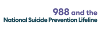
[[Open 988]] | |
| 988 has been designated as the new three-digit dialing code that will route callers to the National Suicide Prevention Lifeline. While some areas may be currently able to connect to the Lifeline by dialing 988, this dialing code will be available to everyone across the United States starting on July 16, 2022. | ||
|
[[Open Data STREAMS]] | |
| This project involves an evaluation framework for open datasets published by the City of Portland. The goal is to create a data analysis tool which provides quality assurance for datasets made available between bureaus and to the public. | ||
| [[Open Network for Education and Skilling Transactions]] | ||
| Beckn-based Open Network for Education and Skilling Transactions (ONEST) | ||

|
[[Open Participatory Budgeting]] | |
| Participatory budgeting (PB) is process in which citizens decide how to allocate part of a municipal or public budget through a process of democratic deliberation and decision-making. Participatory budgeting allows citizens or residents of a locality to identify, discuss, and prioritize public spending projects, and gives them the power to make real decisions about how money is spent. | ||
|
[[Oregon Data Catalog]] | |
| The Oregon Data Catalog is a platform for managing and publishing data sets that are relevant to the state of Oregon in the United States. The platform is based on CKAN, which is a free and open-source software platform for managing and publishing data. | ||

|
[[Oregon Digital Safety Net]] | |
| Digital communications are necessary to participate in mainstream life today.
Those of us who are fortunate enough to be employed, housed, and reasonably healthy and stable, financially and emotionally, know how dependent we are on our digital devices to navigate our daily lives. | ||
|
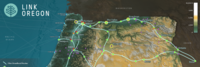
[[Oregon middle-mile fiber broadband network]] | |
| Link Oregon, the non-profit, middle-mile broadband network serving Oregon’s
public and non-profit sectors, delivered the first two phases of its statewide network backbone in June 2021, having successfully lit nearly 2,000 route-miles of fiber-optic cable and deployed more than 50 service locations across Oregon. | ||
|
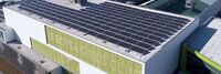
[[PGE Renewable Development Fund]] | |
| The PGE Renewable Development Fund awards grants for clean energy projects in the community. These are funded by PGE customers who choose Green Future renewable energy programs. | ||
|
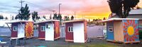
[[Parkrose Community Village]] | |
| WeShine’s first micro-village. Micro-villages are “transitional shelters”, designed to provide safety, privacy, hygiene, and community to people seeking permanent housing. PCV will include paid staff, lockable sleeping pods, laundry, showers, toilets, fencing, and a community building. Volunteers will help with art, gardening, financial literacy, food, pet care, and medical/nursing needs. | ||

|
[[Personal Access System for Services (PASS)]] | |
| Social services are programs or services designed to support individuals and communities in need. They provide assistance with basic needs such as food, housing, and clothing, as well as health and medical care, education and job training, child care, support for individuals with disabilities or mental health conditions, and aging and elder care. These services are intended to improve the quality of life for individuals and communities and help individuals achieve self-sufficiency. | ||
|
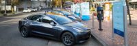
[[Portland Electric Avenue]] | |
| Electric Avenue officially opened at the World Trade Center Portland in 2016 and is located on the Northside of Southwest Salmon Street in downtown Portland. It offers street access charging stations to allow visitors to charge their personal electric vehicles while visiting the World Trade Center and neighboring offices. | ||

|
[[PortlandMaps - Open Data]] | |
| PortlandMaps delivers site-specific property information, neighborhood crime statistics, aerial photos, school information, and tons of additional map data for the City of Portland and beyond. | ||
|
[[Regenerative Urbanism Vanport]] | |
| Vanport, Oregon was a temporary housing project built in 1942 to address a wartime housing shortage in Portland. | ||
|
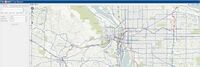
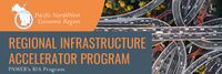
[[Regional Infrastructure Accelerator Program]] | |
| The Pacific NorthWest Economic Region (PNWER) is one of five organizations awarded the U.S. Department of Transportation's Build America Bureau Regional Infrastructure Accelerator (RIA) program grant in its first iteration. PNWER will use grant funds to establish a Regional Infrastructure Accelerator for the Pacific Northwest. The RIA will serve as a convener for transportation projects across the five state member region, specifically multistate and multi-jurisdictional initiatives that are needed, but lack funding for completion. | ||
|
[[Resilience HUB - East Multnomah]] | |
| Resilience Hubs are community-serving facilities augmented to support residents and coordinate resource distribution and services before, during, or after a natural hazard event. They leverage established, trusted, and community-managed facilities that are used year-round as neighborhood centers for community-building activities. Resilience Hubs can equitably enhance community resilience while reducing greenhouse gas emissions and improving local quality of life for our communities. They have the potential to reduce burden on local emergency response teams, improve access to public health initiatives, increase the effectiveness of community-centered institutions and programs. | ||
|
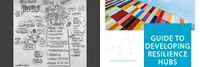
[[Resilience HUB - NIST Guide]] | |
| Natural, technological, and human-caused hazards take a high toll on communities, but the costs in lives, livelihoods and quality of life can be reduced by better managing disaster risks. Planning and implementing prioritized measures can strengthen resilience and improve a community's abilities to continue or restore vital services in a more timely way, and to build back better after damaging events. That makes them better prepared for future events and more attractive to businesses and residents alike. | ||

|
[[Resilience HUB - Vibrant Hawaii]] | |
| A goal of the Resilience Hub initiative is to build individual capacity and community networks to be resilient and ready for anything. To get there, Vibrant Hawai'i hosted a Resilience Leadership Academy (RLA) - a monthly development program with curated content by local experts. | ||

|
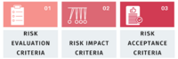
[[Risk Assessment and Prioritization in the Smart City Cyber Resilience Planning Process]] | |
| This use case summarizes an engagement between a GCTC Action Cluster member, Adaptable Security Corp (ADA), and a California municipality, focusing on how the risk management process, with a particular focus on risk assessment and prioritization, played a critical role in the overall cyber resilience planning process. The content covered in this use case primarily aligns with the Prepare, Select, Assess, and Monitor steps of the RMF. | ||
|
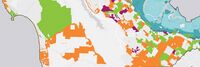
[[Risk Assessment in the County of San Mateo, California]] | |
| This use case describes how risk assessment has been implemented in the County of San Mateo, California, and identifies activities that align most closely with the Step 0: Prepare and Step 6: Monitor steps of the risk management process. However, the assessment process and the outputs from the assessment also involve elements from and inform all of the other risk management steps (i.e., Step 1: Categorize, Step 2: Select, Step 3: Implement, Step 4: Assess, Step 5: Authorize). Refer to Appendix B of this Guidebook for an example of the risk assessment questionnaire and its application. | ||
|
[[Risk Management in a Privacy-Specific Context]] | |
| This use case describes how the risk management concepts and processes presented in this Guidebook apply in privacy-specific applications. Given the overlapping relationship of cybersecurity and privacy, much of the information in this use case may sound similar to, or even identical to, aspects of cybersecurity risk management. This reinforces the notion that cybersecurity and privacy are closely related and should generally be considered in tandem. | ||

|
[[Rose City Resource]] | |
| The Street Roots Rose City Resource (RCR) is a 4’x 4′, 104 page guide that is the most comprehensive, updated list of services for people experiencing homelessness and poverty in Multnomah, Washington and Clackamas counties. | ||

|
[[San Mateo County Public WiFi]] | |
| We live in the heart of Silicon Valley, but even in San Mateo County we have a significant digital divide between those with high speed Internet access and those with slow speed or no access. The County believes that providing high speed Internet access is the 21st century equivalent to building roads. Providing the infrastructure so that all residents have equal access to online resources is critical to supporting our shared vision of a healthy, safe, prosperous, livable, environmentally conscious, and collaborative community. | ||

|
[[Santa Clara County Office of Education CBRS Networks]] | |
| Santa Clara County Office of Education and Joint Venture Silicon Valley are cooperating with industry leaders to deploy CBRS broadband networks for addressing distance learning and homework gap challenges. | ||
|
[[School Organized Locally Assisted Community Emergency‐Management]] | |
| The School Organized Locally Assisted Community Emergency‐Management (SOLACE) project focused on the use of a community school as a community resilience hub for its surrounding community. Community Resilience Hubs (CRHs) can be defined as community‐serving facilities augmented to support residents and coordinate resource distribution of resources and services to the surrounding community. This project focused specifically on the use of a CRM to support community member needs before, during, or after a natural hazard event and on developing a community‐led sociotechnical infrastructure framework for adapting a public school (Buckman Elementary School) as the pilot CRH. In 2022, this project received a NSF Planning Grant. | ||

|
[[Small Donor Elections]] | |
| The Small Donor Elections program seeks to reduce the influence of money in politics and encourage election of people to City office who are reflective of and accountable to all Portlanders. | ||

|
[[Smart Rural Community]] | |
| The Smart Rural Community (SRC) network is made up of a group of carefully vetted, rural broadband providers who are committed to driving growth and creating opportunities for their communities. SRC providers enable fast, reliable and sustainable connectivity needed to thrive in an online world, especially as the demand for distance learning, telemedicine and remote work grows. And for those who live in these communities, it means equal opportunity for education, resources, entrepreneurship and more. | ||
|
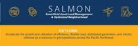
[[SmartGrid Advanced Load Management & Optimized Neighborhood]] | |
| Situated in Portland’s Overlook/Arbor Lodge neighborhood, this project is focused on a disadvantaged, low and moderate income community that is currently facing gentrification. This project represents a mix of retrofitted residential and commercial buildings that are currently part of a PGE SmartGrid TestBed site. Using DERs as resources in bulk capacity markets as a grid service is novel and will serve as a precedent for nearly 100 utilities in the region. | ||

|
[[Solar-Powered Truck Charging Depot]] | |
| WattEV's Bakersfield electric truck charging depot, spanning 119 acres, integrates a solar-powered microgrid with rapid megawatt charging, reducing truck dwell time to under 30 minutes. | ||
|
[[Southport development]] | |
| Southport is the only full-building solution available in the Greater Puget Sound area. As you enter Southport on Lake Washington you will quickly realize you are in a unique place. The entire campus has been designed with a focus on a lifestyle environment that supports the development of great teams. | ||
|
[[State of Place City of Tigard]] | |
| Prior to using State of Place, Tigard did not know where to begin in their data-driven walkability plan for their Tigard Triangle project. The process was cumbersome and error-prone. The City needed a tool that could conduct objective, robust assessments of existing walkability of the Tigard Triangle, and offer impactful recommendations to increase public approval. | ||

|
[[SynchroniCity]] | |
| The opportunities presented by technology are endless. However, societies are still struggling to get long-lasting value out of it, contributing to local priorities. How do we ensure that technology respects our privacy, enables us to live in a more sustainable way and helps us lead a happier life? It has become clear that we need to rethink and improve our development of technology in order to create better living conditions for people. For this reason, we created SynchroniCity, opening up a global market, where cities and businesses develop IoT- and AI-enabled services through pilots to improve the lives of citizens and grow local economies. | ||

|
[[The Norway MegaCharge Project]] | |
| The Green Platform project MegaCharge aims to contribute directly to achieving the goal of a 50% emission reduction in the transport sector by 2030. This will be accomplished by building a complete value chain for the development of charging infrastructure for electric freight transport, also taking into account limitations in grid capacity. | ||

|
[[The Solid Project]] | |
| The Solid project is a decentralized platform for the Web that he and a team of researchers at MIT are developing. The goal of the Solid project is to give people more control over their personal data and how it is used by enabling them to store their data on their own servers or "pods," rather than on centralized servers controlled by companies. | ||
|
[[Toronto Quayside]] | |
| The new Waterfront Toronto project has learned from the past. Plans call it Quayside 2.0 and show trees and greenery sprouting from every possible balcony and outcropping, with nary an autonomous vehicle or drone in site. The project’s highly accomplished design team—led by Alison Brooks, a Canadian architect based in London; the renowned Ghanaian-British architect David Adjaye; Matthew Hickey, a Mohawk architect from the Six Nations First Nation; and two Danish firms, Henning Larsen Architects and the nature-based design studio SLA—all speak of this new corner of Canada’s largest city not as a techno-utopia but as a bucolic retreat. | ||
|
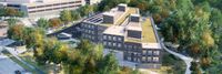
[[Toronto and Region Conservation Authority Headquarters]] | |
| This project is part of a group of 16 chosen to participate in a two-year pilot of “CaGBC’s Zero Carbon Building Standard” which will help to further refine the standard, plus accompanying resources and education. TRCA’s new headquarters will be utilized as a learning centre – a living laboratory for developers, researchers, professionals and students that will contribute to the uptake of improved methods and technologies that demonstrate zero carbon features and green infrastructure restoration. The concept design incorporates strategies and technology for renewable energy, innovative wastewater management and integration with the ravine landscape. | ||

|
[[U.S. Central Bank Digital Currency]] | |
| The Digital Dollar Project is a partnership between Accenture (NYSE: ACN) and the Digital Dollar Foundation to advance exploration of a United States Central Bank Digital Currency (CBDC). The purpose of the Project is to encourage research and public discussion on the potential advantages of a digital dollar, convene private sector thought leaders and actors, and propose possible models to support the public sector. The Project will moderate programs with interested stakeholders to measure the value of and and establish practical steps that can be taken to establish a digital dollar. | ||

|
[[Urban Platform]] | |
| An easy-to-use platform that allows you to manage your city, whether you are responsible for traffic and mobility, safety, infrastructure or high-level decision making. | ||

|
[[V2G Electric School Bus Commercialization Project]] | |
| Project is addressing VTO’s core objective of reducing the cost of PEVs, and VTO’s specific Electrification R&D objective of understanding the potential impacts of EV charging on the nation’s electric grid – in both cases through pioneering V2G technology in heavy-duty vehicles | ||
|
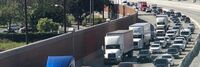
[[West Coast Clean Transit Corridor]] | |
| The West Coast Clean Transit Corridor Initiative is an ongoing, collaborative effort among 16 utilities to support the development of electric vehicle charging facilities along I-5, from San Diego to British Columbia, for heavy- and medium-duty freight haulers and delivery trucks. | ||
|
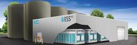
[[Wilsonville Long-Duration Storage System Demonstration]] | |
| Build a 3 MWh Long-Duration Storage System to demonstrate multiple use cases, including frequency response, contingency reserve, voltage and VAR support, demand response and resource optimization. The project will be located on land adjacent to ESS’ factory headquarters in Wilsonville, Oregon. | ||
|
[[Yachats Resilient Civic Campus Plan]] | |
| A Resilient Civic Campus Planning process was conducted by the City of Yachats to convene the community and consider how renewable power could help prepare for hazard events and leverage improvements supporting community resilience | ||