Semantic search

|
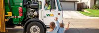
[[Solar-Powered Truck Charging Depot]] | |
| WattEV's Bakersfield electric truck charging depot, spanning 119 acres, integrates a solar-powered microgrid with rapid megawatt charging, reducing truck dwell time to under 30 minutes. | ||
|
[[Solid Waste Management IoT Solution]] | |
| Garbage and refuse collection management is a critical function for any municipal government and private township. Inefficient or irregular collection leads to unsafe disposal by the public, which in turn creates conditions hostile to commerce and public health. Accelerite has developed an AWS solution on its Concert IoT platform that offers ready to use “Smart City” solid waste management IOT services.
The possibilities for creating public/ private sector revenue generating ecosystems are vast (e.g. selling recyclables and compostable waste to the highest bidder, revenue sharing with citizens to reward participation). Concert IoT’s Service Exposure and Monetization modules make it possible to expose services to partners for further innovation such that they can be consumed in a secure access and payments/settlements charging policy enforced manner. | ||
|
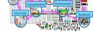
[[South Bend Technology Resource Center- A Collaboration Platform for a Responsive Inclusive Beta City]] | |
| South Bend prides itself on being a Beta City – a City that embraces new technology, creative partnerships, and new approaches to improve resident experiences and service delivery. | ||

|
[[Southport development]] | |
| Southport is the only full-building solution available in the Greater Puget Sound area. As you enter Southport on Lake Washington you will quickly realize you are in a unique place. The entire campus has been designed with a focus on a lifestyle environment that supports the development of great teams. | ||
|
[[State of Place City of Tigard]] | |
| Prior to using State of Place, Tigard did not know where to begin in their data-driven walkability plan for their Tigard Triangle project. The process was cumbersome and error-prone. The City needed a tool that could conduct objective, robust assessments of existing walkability of the Tigard Triangle, and offer impactful recommendations to increase public approval. | ||
| [[StormSense]] | ||
Objectives
| ||
|
[[Supercomputer Modeling and Artificial Intelligence Cluster for Smart Cities and Regions]] | |
| National and International Innovation eco-system to serve challenges by using high-performance supercomputers to utilize existing and create novel Artificial Intelligence to develop Smart Cities and Region services, including resilience solutions (Net Zero Energy Buildings and Districts, Carbon Neutrality, Advanced Energy Penetration, Energy Efficiency, Advanced Mobility Solutions, Environmental Health, Public Safety, Disaster Management, V2X Electrification, Climate and Water).
This Cluster will deploy both proven, and newly devised, large-scale Smart City and Region supercomputing predictive analytics to model regional pathways into resiliency with identification of scientific and marketplace solutions to provision and deploy the right Smart City and Region solution stacks. AI models will include the next generation of Artificial Intelligence, including Complex Systems Simulations, Emulation, and Optimization in order to create highly efficient and robust “autonomous systems” and portfolio-scale analytics and automated services. The predictive analytics developed by Innovation Corridor’s national lab partners will be part of the initial portfolio and baseline. The Action Cluster will develop a repository of Artificial Intelligence technologies and architectures from founders (Innovation Corridor and Powering IoT) together with eco-system partners in order to fast track the next generation of automated, resilient, cyber secure, environmentally friendly and intelligence-driven distributed systems for Smart Cities and Smart Regions. In addition, new forms of Artificial Intelligence technologies and systems will be developed within this Action Cluster such as a "Personal Digital Twin" - a personal digital avatar that will purposefully and mindfully serves each citizen within a society. Large-scale compute intensive data sets will train Artificial Intelligence solutions prior to deployment, which will be sourced from a range of partners, jurisdictions and localities and used to refine our Cluster Artificial Intelligence predictive analytics. An eco-system of cities, regions, federal research labs, private sector technology companies and universities provide a unique framework and sandbox to support the deployment of Smart Cities enabling technologies and the provision of resiliency-based and Artificial Intelligence solutions for Smart Cities and Smart Regions. | ||

|
[[SynchroniCity]] | |
| The opportunities presented by technology are endless. However, societies are still struggling to get long-lasting value out of it, contributing to local priorities. How do we ensure that technology respects our privacy, enables us to live in a more sustainable way and helps us lead a happier life? It has become clear that we need to rethink and improve our development of technology in order to create better living conditions for people. For this reason, we created SynchroniCity, opening up a global market, where cities and businesses develop IoT- and AI-enabled services through pilots to improve the lives of citizens and grow local economies. | ||
|
[[Taipei Smart City Living Lab]] | |
* Taipei has been transformed into a living lab through the efforts of public-private partnership. The matchmaking mechanism efficiently solves city problems and citizen demands, as well as instantly promoting government plans and integrating private resources. It is a much more positive and comprehensive approach, compared to the methods adopted by other cities, promoting their projects either in a top-down or bottom-up fashion.
| ||
|
[[Taipei Smart City Programme]] | |
Taipei Smart City revolves around
| ||
|
[[Taoyuan City Water Resources Information System]] | |
| The core value of the System is to protect life and properties of people. The major purpose of developing the System is to apply technology of Smart Disaster Prevention and Internet of Things (IoT), and to build a resilient and sustainable city. | ||

|
[[Taoyuan Mobile Citizen Card]] | |
| In respond to the needs of mobile payment and the popularization of mobile devices, Taoyuan City Government works with telecom companies and e-ticket companies to integrate the citizen card into the sim card of a mobile phone so that citizens are allowed to enjoy all the functions and service of a citizen card on their phone such as borrowing books, taking trains/metros/buses, renting Ubikes, purchasing at a convenience store, accumulating bonuses, etc., and getting special discounts at certain stores. Citizens are thus given more options in ways to use their citizen cards. | ||

|
[[Taoyuan citizen card]] | |
| In respond to the rapid growth of Taoyuan’s population, the upgrading of government service, the development of industries, and the popularization of urban infrastructure, the card intends to connect the government, businesses, and citizens and integrate service. Business resources are also integrated to create a win-win collaborative model for citizens, businesses, and the government. | ||

|
[[Tech-secure City]] | |
| “Smart police” take advantage of ICT development which can ensure citizen’s high quality of life, improve effective and accurate services, reduce police’s burden and increase citizens’ satisfaction. That’s the reason we utilize ICT and innovative strategies to deploy and construct a safe city. | ||
|
[[The Great Lakes Smart and Sustainable Cities Cluster]] | |
| The Council of Great Lakes Region (CGLR) Regional Action Cluster will address the United Nations’ seventeen Sustainability Development Goals (SDGs) by consistently measuring sustainability at the neighborhood, city, state/provincial and regional levels. The cluster will also develop a framework to measure human well-being and ecosystem services by identifying bottom-up citizen co-creation actions taken across institutional boundaries. Open Action dashboards will display progress and link to knowledge achieving stated goals and objectives around the SDGs. | ||

|
[[The Inclusive Smart City]] | |
| An AI-augmented skills-based jobs placement programme by the Singapore infocomm Technology Federation (SiTF) to help mature and displaced workers transition effectively into the tech sector. The programme will be a combination of AI tools and high-touch engagements to drive outcomes.
This effort is also integrated into a larger national initiative called TeSA (TechSkills Accelerator) to improve the employability of Singaporeans and to meet the demand for skilled tech workforce by different industries across the economy. TeSA involves key industry and employer associations, tech companies in different sectors of the economy, key enterprise users of technology in different industries, government agencies both economic and regulatory ones, labour unions, students and professionals. TeSA is steered through a national Governing Council and various Sector Committees representing different industries. TeSA is led by the Infocomm Media Development Authority of Singapore (IMDA), with other partner agencies. Both TeSA and talentguru AI-driven platform have been launched. New efforts are being developed and launched on an on-going basis. | ||
|
[[The Integrated Information Platform for Smart Transportation of Tainan City]] | |
| After merging Tainan City with Tainan County to be Greater Tainan, the changes in environmental factors such as transportation infrastructure and population increase have made the traffic management work more diverse and arduous. Based on the challenges, a smart system is necessary to enable more accurate and effective decision-making and traffic management. A cross-organized, integrated and IOT value-added systems including intelligent traffic control, smart public transportation, smart parking management, smart vehicle sharing, and smart cloud platform is proposed and developed. | ||

|
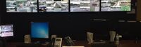
[[The NTT Smart Cities Solution for the City of Las Vegas]] | |
| NTT Smart Cities Solution leverages IoT edge analytics for public safety. High definition video cameras, sound and motion sensors, and an array of IoT devices are integrated and deployed to monitor a location or venue to create a multi-channel solution. The solution, in turn, provides situational awareness, warnings and alerts to city agencies and venue security teams of incidents as they develop.
The system proactively provides early notification of potential and active public safety incidents to command and control authorities. If the city deems it appropriate they then notify the appropriate first responders. By leveraging advanced analytics including machine learning technologies, the system “learns” normal patterns and detects patterns that appear abnormal. The initial use cases are limited to specific types of incidents that can be detected through video and sound sensor analytics running on edge compute devices as well as social media monitoring. As the system evolves, we expect to expand detection capabilities to detect and alert to a wider variety of incident types. Our current solution includes technology for “lost person” identification and “vehicle identification”, to assist should an Amber Alert be issued. It also includes wrong way vehicle detection. Future plans could also include facial recognition modules or other advanced detection components and may also include more automated incident response component for greater awareness of the developing situation. | ||

|
[[The Solid Project]] | |
| The Solid project is a decentralized platform for the Web that he and a team of researchers at MIT are developing. The goal of the Solid project is to give people more control over their personal data and how it is used by enabling them to store their data on their own servers or "pods," rather than on centralized servers controlled by companies. | ||

|
[[The mobile Edge Smart City Platform]] | |
Key Deliverables
| ||
|
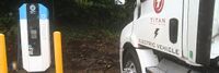
[[Titan Freight Systems all-electric trucks for local deliveries]] | |
| Titan Freight Systems is currently implementing a project to transition to all-electric trucks for local deliveries in Oregon, Washington, and Northern Idaho. This initiative aims to reduce greenhouse gas emissions and promote sustainability in the transportation sector. The project includes the deployment of three all-electric box trucks from Daimler, specifically the Freightliner eM-2 model, alongside existing electric tractor trailers. These vehicles will cover approximately 150,000 miles of zero-emission deliveries, contributing significantly to environmental conservation efforts. The project involves collaboration with Daimler, Portland General Electric, and other stakeholders, demonstrating a commitment to technological advancement and environmental responsibility in freight transportation. | ||
|
[[Toronto Quayside]] | |
| The new Waterfront Toronto project has learned from the past. Plans call it Quayside 2.0 and show trees and greenery sprouting from every possible balcony and outcropping, with nary an autonomous vehicle or drone in site. The project’s highly accomplished design team—led by Alison Brooks, a Canadian architect based in London; the renowned Ghanaian-British architect David Adjaye; Matthew Hickey, a Mohawk architect from the Six Nations First Nation; and two Danish firms, Henning Larsen Architects and the nature-based design studio SLA—all speak of this new corner of Canada’s largest city not as a techno-utopia but as a bucolic retreat. | ||
|
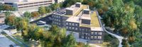
[[Toronto and Region Conservation Authority Headquarters]] | |
| This project is part of a group of 16 chosen to participate in a two-year pilot of “CaGBC’s Zero Carbon Building Standard” which will help to further refine the standard, plus accompanying resources and education. TRCA’s new headquarters will be utilized as a learning centre – a living laboratory for developers, researchers, professionals and students that will contribute to the uptake of improved methods and technologies that demonstrate zero carbon features and green infrastructure restoration. The concept design incorporates strategies and technology for renewable energy, innovative wastewater management and integration with the ravine landscape. | ||

|
[[Transactive Energy for Smart Cities]] | |
| This project makes use of PowerMatcher-IoT from project defined at http://www.powermatcher-iot.com which uses IEEE P1451.99 IoT Harmonization and an IoT Broker at http://www.ipdx.net software developed in Sweden. The project adds IoT XMPP to bridge any IoT protocol to provide cyber protection of privacy to meet Global Data Protection Regulations (GDPR) in the EU that can also be use else where including the US and facilitates data sharing for monetization of eDaler a new eDaler (Digital Currency) developed in Sweden and the United States. New CyberAI concerns will be evaluated to determine what conditions will require protection by allowing the owner of devices to determine what or who can control of situations in the city or if connected to an industrial or manufacturing facility that operation of a device does not create an unsafe condition for the plant or when used in a smart city that it does not potentially harm humans. | ||
|
[[Transit Response]] | |
| Cities and states are acting to slow progress of the COVID-19 pandemic by shuttering all nonessential businesses, closing schools, and urging residents to hunker down at home. As a result, ridership has fallen off for many mass transit systems across the country — light rail, streetcar, buses and ferries — as officials work to keep service running. | ||

|
[[Tri-State Region-PA-WV-OH-Food System Project]] | |
| This project intends to develop and implement a plan to increase the supply of local food available to residents of the Pittsburgh food shed (200 mile radius) in several states. By using a data-driven strategic plan as a guide, it envisions a series of targeted interventions to increase the number of producers, add to the variety of the local food inventory, create and enhance aggregation entities to the distribution system, reduce choke-points in supply chains, expand the number of distribution opportunities, and organize consumer demand in ways that improve the equitability of the food system. | ||

|
[[U.S. Central Bank Digital Currency]] | |
| The Digital Dollar Project is a partnership between Accenture (NYSE: ACN) and the Digital Dollar Foundation to advance exploration of a United States Central Bank Digital Currency (CBDC). The purpose of the Project is to encourage research and public discussion on the potential advantages of a digital dollar, convene private sector thought leaders and actors, and propose possible models to support the public sector. The Project will moderate programs with interested stakeholders to measure the value of and and establish practical steps that can be taken to establish a digital dollar. | ||

|
[[UPsouth]] | |
| UPsouth a technology platform that supports Auckland Council connect with young citizens and empower them to become civic entrepreneurs. The Southern Initiative (TSI) is a place-based initiative in South Auckland, New Zealand, that aims to create a prosperous, resilient area where communities thrive. To deliver on its mission, TSI wanted a way to engage with young people in South Auckland. Itsnoon’s civic empowerment platform ‘UPsouth’ enabled young people, of Māori, Pasifika and other ethnic backgrounds, aged 15-24, generate thousands of thoughts, ideas and commentary on important local issues while earning micropayments for their contributions. | ||
|
[[US States Case Studies & Guidance]] | |
| A collection of US States Case Studies & Guidance | ||
|
[[Underground Infrastructure Sensing and Mapping]] | |
| Use sensing and information technology to determine the state of infrastructure and provide it in an appropriate, timely and secure format for the managers, planners and users. Information processing techniques convert the data in information-laden databases for use in analytics, graphical presentations, metering and planning. | ||

|
[[Unraveling the Intersection of Incarceration Homelessness and Mental Health]] | |
| Perform analytics to understand the profiles of people who are high utilizers of emergency and social services and are incarcerated regularly. Data sources will be added over time to create a system that will allow workers at hospitals, jails, social services, or EMS to better understand the history and needs of the person with whom they are working in order to provide community support services necessary to break the cycle of incarceration and homelessness. | ||
|
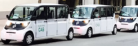
[[Urban Circulators utilizing Low Speed Electric Vehicles]] | |
| Urban Circulators utilizing LSEVs (Low Speed Electric Vehicles) as first/last mile solution in conjunction with public transportation, to serve transit deserts, food deserts and reach underutilized areas of medium to large cities. The scalability of the project would be able to translate to business complexes, universities and hospitals, to transport their customers and reduce traffic congestion. The environmental impact in using electric vehicles would reduce gas emissions. | ||

|
[[Urban Mobility Transit Portal for 511 org]] | |
| The goal was to build a new 511.org site to meet the growing demands of urban mobility commuters in the San Francisco Bay Area. 511.org should be the ultimate destination for commuters to plan their route to have the easiest time getting to their destination. 511.org should also incorporate all of the available data across transit agencies and systems into this single destination. | ||

|
[[Urban Platform]] | |
| An easy-to-use platform that allows you to manage your city, whether you are responsible for traffic and mobility, safety, infrastructure or high-level decision making. | ||
|
[[User-centered Heterogeneous Data Fusion for Multi-networked City Mobility UHDNetCity]] | |
Both sentient and sensual, the smart city is based on the identification of millions of occurrences around the mobility from evaluating residents consumption of water and energy, to recording traffic on road network, to communication network congestion on hot spots, to measure air quality, and tracking public opinions on social networks. This project aims to characterize urban mobility in smart cities, which are interconnected and interdependent sociotechnical systems. Our objectives are:
| ||
|
[[Using Real-Time Traffic Data to Improve Civic Transportation Services]] | |
| This project will expand Chapel Hill’s Data program to incorporate Waze real-time traffic data.
Chapel Hill already uses the OpenDataSoft platform to share public data across the town government and with citizens. This project will allow to the town to quickly and seamlessly collect, harmonize and analyze real-time traffic data through the Waze Connected Citizens Program. The Waze Connected Citizen is a free data exchange program. The OpenDataSoft platform enables the two-way free data exchange between Waze and Chapel Hill and provides tools to analyze the data and compare it with other transportation data already offered by the town. | ||

|
[[V2G Electric School Bus Commercialization Project]] | |
| Project is addressing VTO’s core objective of reducing the cost of PEVs, and VTO’s specific Electrification R&D objective of understanding the potential impacts of EV charging on the nation’s electric grid – in both cases through pioneering V2G technology in heavy-duty vehicles | ||
|
[[Video Analytics for Orlando Public Safety]] | |
| The project will create connected, city-wide mobile resources and systems to help improve the responses to a variety of challenges within the City of Orlando. Orlando is central city of 275,000 people, in an urban area of 2.4 million citizens, but with 68+ million visitors per year and the largest rental car market in the world. Thus, Orlando has some unique challenges with public safety and traffic. This project will meet the needs of several city departments and external agencies by ensuring cross-cutting and robust situational awareness for a variety of scenarios. It will allow for optimized deployments and expedited responses from police, fire fighters, emergency medical services, public works staff, transportation staff, special event managers, and external agencies which are obligated to provide mutual aid. | ||
|
[[Video Chat for Emergency Medical Calls to 9-1-1]] | |
| One of the most dangerous tasks for healthcare providers and first responders is coming into contact with people who show symptoms but may not have the pandemic disease or others who have the virus but do not show symptoms. Several companies make software to allow first responders and healthcare providers to conduct quick and secure video conferences with 9-1-1 callers and those showing symptoms. The 9-1-1 telecommunicator or responder/provider texts a link to the caller/patient’s smartphone. The patient clicks on the link to establish the secure video call. When the call ends the link also expires. No app is required by the patient to make the call. | ||

|
[[Virtual Care Delivery Model to Sustainably Expand the Capacity and Reach of Health Systems to Deliver High-Quality Care in Rural Communities]] | |
Objectives
| ||

|
[[Wabash Heartland Innovation Network - Advancing Agriculture and Manufacturing via IoT]] | |
| The Wabash Heartland Innovation Network (WHIN) is a consortium of 10 counties in north-central Indiana, funded by the Lilly Endowment, devoted to working together to fuel prosperity by harnessing the power of internet-enabled sensors to develop our region into a global epicenter of digital agricultural and next-generation manufacturing. | ||

|
[[Water Application Management]] | |
| Watering the grass is one of those activities that is usually a “set it and forget it” process. But when you have 25 million square feet of landscape under irrigation, you can’t afford to waste a single drop. In our situation 1” of overwatering can cost as much as $40,000 a year.
So we set out to create a computerized “smart system” that operates with very little human intervention and is active and available at all times. This system is able to give directions to the over 456 field controller locations and receive feedback to help calibrate the system only applying what is necessary to keep the plant material healthy and thriving. There are many horticultural aspects that go into keeping landscape healthy. Of these water is among the most critical. Knowing exactly how much water to use is impossible unless you have a way to measure output and monitor system performance. We created a method to do just that. This method is controlled from a central location and can be accessed on tablets in the field. | ||

|
[[Web-based Platform To Quickly Test New Technologies For Cities]] | |
| UrbanLeap empowers cities to test new technologies in an easy and actionable way:
• Enables cities to manage and track the life cycle of pilot projects • Saves staff time by streamlining and automating processes • Supports interdepartmental and intercity collaboration and vendor participation | ||
|
[[West Coast Clean Transit Corridor]] | |
| The West Coast Clean Transit Corridor Initiative is an ongoing, collaborative effort among 16 utilities to support the development of electric vehicle charging facilities along I-5, from San Diego to British Columbia, for heavy- and medium-duty freight haulers and delivery trucks. | ||

|
[[Wilsonville Long-Duration Storage System Demonstration]] | |
| Build a 3 MWh Long-Duration Storage System to demonstrate multiple use cases, including frequency response, contingency reserve, voltage and VAR support, demand response and resource optimization. The project will be located on land adjacent to ESS’ factory headquarters in Wilsonville, Oregon. | ||
|
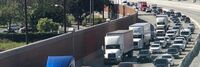
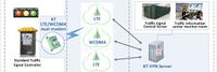
[[Wireless LTE Traffic Signal Control System Using IoT technology for all crossroads in Gunpo-city South Korea]] | |
| The Gunpo City traffic signal system was created with a voluntary idea, based on the experience of operating a traffic information system and with the application of the latest IT technology trend.
Thus, we have prepared a stepping stone for the provision of traffic signal information to the private sector in the era of automated vehicles of the 4th Industrial Revolution which had not felt concrete until now. | ||
|
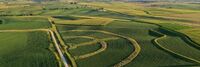
[[Wireless Living Lab for Smart Agriculture and Rural Communities]] | |
* Establish a wireless living lab at an Iowa State University research farm for cross-domain, cross-discipline research, education, and pilot of smart ag and rural connectivity solutions
| ||
|
[[Wireless Networks for Rural Distance Learning Telemedicine and Digital Inclusion]] | |
| Most U.S. states have ordered residents to shelter-in-place in response to the SARS-CoV-2 pandemic. This presents significant challenges for residents in areas with poor or no broadband service, preventing them from using the internet to access distance learning resources, contact health care providers while remaining sheltered, accessing online shopping, and other online activities that most people take for granted.
Residents need three things to overcome digital inclusion gaps: a suitable computing device, high-speed internet, and digital literacy. People with Access & Functional Needs (AFNs) cannot easily overcome the digital inclusion challenge without assistance from local governments, telecommunication providers, and corporate partners. Some AFN communities are attempting to creatively solve the connectivity challenge by retrofitting school buses and “Bookmobiles” with Wi-Fi equipment and then parking them in neighborhoods with AFN residents. In some cases, schools and public libraries are petitioning the Federal Communications Commission (FCC) to waive some E-rate rules so they can open up their networks to the surrounding community. There are some significant downsides to this approach:
An alternative that can provide broadband service to AFN residents in areas that are unserved or underserved by existing telecommunication networks is to enhance the 4G LTE infrastructure to provide additional coverage – specifically indoor coverage – to a broader range of locations, by building temporary wireless sites near the areas of need. Once the sites are in place, government or community groups can provide AFN residents with a hotspot, or an inexpensive smartphone to be used as a Wi-Fi hotspot. There are various configurations possible to provide broadband service to the largest number of AFN residents while keeping costs low, utilizing available equipment, and operating within legal and regulatory constraints:
This concept paper Wireless Networks for Distance Learning details each of these configurations, examines the pros and cons of each method, and explores funding options. | ||

|
[[WiseTown]] | |
| W.I.S.E. Town stands for Web Information Streams Enhancer for your Town. The goal of this solution is to collect information from different streams to identify the issues that affect the city in several areas: urban renewal, garbage collection, public safety, transportation, social services and environmental problems. | ||

|
[[World Digital School]] | |
| Cities and communities around the world are entering the next era of transformational change in which citizens and their surrounding natural and built environments are increasingly connected by digital technologies. In the coming digital industrial revolution, technology will widen the playing field to include greater participation of individuals and ideas from all walks of life as we reinvent who and what we are. These technologies not only have the potential to build a more inclusive community, but when thoughtfully applied could help realize greater socio-economic gains. Conversely, if these technologies are not available to all, we would fragment our communities more than they are today.
Smart Cities are %90 sociology and %10 infrastructure. | ||