| Data
|

|
|
|
| Sectors |
Data
|
| Contact |
Wilfred Pinfold
|
| Topics |
|
Activities

|
|
CITYDASH City-wide analytics dashboard from public and private data sources
|
Data analytics and insights powered by machine intelligence for 4 target city departments:
- 311 crowd-sourced civic issues
- Recreation and Parks programs
- Crime reports and police data
- Building and Engineering permits
|
|
|
|
|
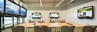
Decision Theatre PSU
|
| Portland State University’s Decision Theater is designed for university researchers and regional stakeholders (i.e. government, private companies) to work on projects that “link data sets, visualization and decisions,” according to a university statement. The space is modeled after Arizona State University's Decision Theater, as well as a similar facility at the University of Chicago.
|
|
|

|
|
Digital Strategy Borchen-Etteln
|
| To further increase the quality of life for all people in Borchen-Etteln and to develop the economic, social and ecological potential. In doing so, we take into account the interests of all age groups
|
|
|
|
|
Digital Twin: Emergency Communication Services
|
| Establishes a practical approach for management of emergency and incident response with a common operating picture.
|
|
|
|
|
Digital Twin: Infectious Disease Management
|
| Link time, spatial and sensor data with existing enterprise data to enable new insights.
|
|
|

|
|
Digital Twin: Manufacturing Quality Control Via Remote Operator
|
| The post-Covid world necessitates remote verification of manufacturing components – in real-time, as they are conveyed across the manufacturing line.
|
|
|
|
|
Emergency Communication Services
|
| Establishes a practical approach for management of emergency and incident response with a common operating picture.
|
|
|

|
|
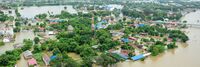
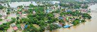
Flood Judge
|
| Combining low cost / commodity sensors, enterprise IT skillsets, existing / familiar tools with the power of the cloud and artificial intelligence to proactively monitor and alert water levels in creeks during storm activity.
|
|
|

|
|
Point Cloud City - Hancock County Mississippi
|
| Develop approaches which improve indoor mapping techniques and datasets in the US to make them more common and available for use nationwide.
|
|
|

|
|
Point Cloud MAP901 Building Rich Interior Hazard Maps for First Responders
|
| Build a catalog of 3D maps with clear identification of safety-related objects to help first responders navigate safely and quickly during emergency/crisis.
|
|
|

|
|
Smart Cities Dashboard in the City of Bellevue WA
|
Install a pilot GIS-based visual dashboard to provide improvements in the following sectors:
- Safety and security – provide greater coverage and more efficient deployment of emergency services
- Transportation – provide better street lighting and traffic control
- Operational efficiencies – improve efficiency of water distribution, energy efficiency in buildings, response times, and reduce costs
- Interactive citizen engagement – keeping residents and tourists better informed
- Improve communications and information sharing between departments
|
|
|
|
|
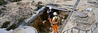
Underground Infrastructure Sensing and Mapping
|
| Use sensing and information technology to determine the state of infrastructure and provide it in an appropriate, timely and secure format for the managers, planners and users. Information processing techniques convert the data in information-laden databases for use in analytics, graphical presentations, metering and planning.
|
|
|

|
|
WiseTown
|
| W.I.S.E. Town stands for Web Information Streams Enhancer for your Town. The goal of this solution is to collect information from different streams to identify the issues that affect the city in several areas: urban renewal, garbage collection, public safety, transportation, social services and environmental problems.
|
|
|
Press

|
|
Newest Industry Working Group
|
| The DTC Telecommunications Working Group is chartered to drive the application and adoption of digital twins in the global telecom market.
|
|
|
|
- Authors

A digital twin is a virtual representation of a physical object or system that can be used for various purposes such as simulation, analysis, and control. It is typically created using data from sensors and other sources to replicate the object's behavior and characteristics, and can be used for a wide range of applications, including manufacturing, aerospace, and infrastructure.
Digital twins can be used in a variety of fields, such as manufacturing, construction, healthcare, and transportation, to help with design, testing, and optimization of the physical systems. The twin can be used to test and validate changes to the physical system, such as new manufacturing processes or product designs, without having to make those changes in the physical world.
Digital twins can also be used to monitor and predict the performance of a physical system, allowing for proactive maintenance and reducing the risk of downtime. For example, a digital twin of a wind turbine can be used to predict potential failures or malfunctions and allow for preventative maintenance to be performed before an actual failure occurs.
Overall, the use of digital twins can help reduce costs, increase efficiency, and improve safety and reliability in a wide range of applications.
