Semantic search
|
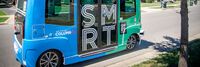
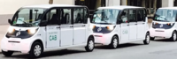
[[SmartShuttle]] | |
| Our second autonomous vehicle pilot will build upon the “lessons learned” from our GCTC 2015 “First Mile/Last Mile” study (GCTC Action Cluster SMOOTH). The City of Columbus was recently named one of the seven finalists in the US Department of Transportation Smart City Challenge. Our GCTC 2016 project will, therefore, concentrate on a scalable and replicable low speed automated shuttle solution for use in the Smart City of Columbus. This automated shuttle solution will use a small (two-seater) electric driverless vehicle with a scalable and replicable software, hardware control and decision making architecture. The eventual aim of the project is pilot deployment in an urban driving environment with low speed vehicles and intersections at/near the outdoor shopping area of Easton Town Center in Columbus. The scalable and replicable approach will enable the easy adaptation of the same system to other parts of the City of Columbus and to other similar pilot deployment sites in other cities in the US. | ||

|
[[Solar-Powered Truck Charging Depot]] | |
| WattEV's Bakersfield electric truck charging depot, spanning 119 acres, integrates a solar-powered microgrid with rapid megawatt charging, reducing truck dwell time to under 30 minutes. | ||

|
[[Southport development]] | |
| Southport is the only full-building solution available in the Greater Puget Sound area. As you enter Southport on Lake Washington you will quickly realize you are in a unique place. The entire campus has been designed with a focus on a lifestyle environment that supports the development of great teams. | ||
|
[[The Integrated Information Platform for Smart Transportation of Tainan City]] | |
| After merging Tainan City with Tainan County to be Greater Tainan, the changes in environmental factors such as transportation infrastructure and population increase have made the traffic management work more diverse and arduous. Based on the challenges, a smart system is necessary to enable more accurate and effective decision-making and traffic management. A cross-organized, integrated and IOT value-added systems including intelligent traffic control, smart public transportation, smart parking management, smart vehicle sharing, and smart cloud platform is proposed and developed. | ||
|
[[The Norway MegaCharge Project]] | |
| The Green Platform project MegaCharge aims to contribute directly to achieving the goal of a 50% emission reduction in the transport sector by 2030. This will be accomplished by building a complete value chain for the development of charging infrastructure for electric freight transport, also taking into account limitations in grid capacity. | ||

|
[[The mobile Edge Smart City Platform]] | |
Key Deliverables
| ||
|
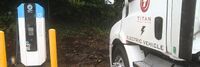
[[Titan Freight Systems all-electric trucks for local deliveries]] | |
| Titan Freight Systems is currently implementing a project to transition to all-electric trucks for local deliveries in Oregon, Washington, and Northern Idaho. This initiative aims to reduce greenhouse gas emissions and promote sustainability in the transportation sector. The project includes the deployment of three all-electric box trucks from Daimler, specifically the Freightliner eM-2 model, alongside existing electric tractor trailers. These vehicles will cover approximately 150,000 miles of zero-emission deliveries, contributing significantly to environmental conservation efforts. The project involves collaboration with Daimler, Portland General Electric, and other stakeholders, demonstrating a commitment to technological advancement and environmental responsibility in freight transportation. | ||
|
[[Urban Circulators utilizing Low Speed Electric Vehicles]] | |
| Urban Circulators utilizing LSEVs (Low Speed Electric Vehicles) as first/last mile solution in conjunction with public transportation, to serve transit deserts, food deserts and reach underutilized areas of medium to large cities. The scalability of the project would be able to translate to business complexes, universities and hospitals, to transport their customers and reduce traffic congestion. The environmental impact in using electric vehicles would reduce gas emissions. | ||

|
[[Urban Mobility Transit Portal for 511 org]] | |
| The goal was to build a new 511.org site to meet the growing demands of urban mobility commuters in the San Francisco Bay Area. 511.org should be the ultimate destination for commuters to plan their route to have the easiest time getting to their destination. 511.org should also incorporate all of the available data across transit agencies and systems into this single destination. | ||

|
[[Urban Platform]] | |
| An easy-to-use platform that allows you to manage your city, whether you are responsible for traffic and mobility, safety, infrastructure or high-level decision making. | ||
|
[[User-centered Heterogeneous Data Fusion for Multi-networked City Mobility UHDNetCity]] | |
Both sentient and sensual, the smart city is based on the identification of millions of occurrences around the mobility from evaluating residents consumption of water and energy, to recording traffic on road network, to communication network congestion on hot spots, to measure air quality, and tracking public opinions on social networks. This project aims to characterize urban mobility in smart cities, which are interconnected and interdependent sociotechnical systems. Our objectives are:
| ||

|
[[Using Real-Time Traffic Data to Improve Civic Transportation Services]] | |
| This project will expand Chapel Hill’s Data program to incorporate Waze real-time traffic data.
Chapel Hill already uses the OpenDataSoft platform to share public data across the town government and with citizens. This project will allow to the town to quickly and seamlessly collect, harmonize and analyze real-time traffic data through the Waze Connected Citizens Program. The Waze Connected Citizen is a free data exchange program. The OpenDataSoft platform enables the two-way free data exchange between Waze and Chapel Hill and provides tools to analyze the data and compare it with other transportation data already offered by the town. | ||
|
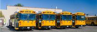
[[V2G Electric School Bus Commercialization Project]] | |
| Project is addressing VTO’s core objective of reducing the cost of PEVs, and VTO’s specific Electrification R&D objective of understanding the potential impacts of EV charging on the nation’s electric grid – in both cases through pioneering V2G technology in heavy-duty vehicles | ||

|
[[Web-based Platform To Quickly Test New Technologies For Cities]] | |
| UrbanLeap empowers cities to test new technologies in an easy and actionable way:
• Enables cities to manage and track the life cycle of pilot projects • Saves staff time by streamlining and automating processes • Supports interdepartmental and intercity collaboration and vendor participation | ||
|
[[West Coast Clean Transit Corridor]] | |
| The West Coast Clean Transit Corridor Initiative is an ongoing, collaborative effort among 16 utilities to support the development of electric vehicle charging facilities along I-5, from San Diego to British Columbia, for heavy- and medium-duty freight haulers and delivery trucks. | ||
|
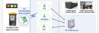
[[Wireless LTE Traffic Signal Control System Using IoT technology for all crossroads in Gunpo-city South Korea]] | |
| The Gunpo City traffic signal system was created with a voluntary idea, based on the experience of operating a traffic information system and with the application of the latest IT technology trend.
Thus, we have prepared a stepping stone for the provision of traffic signal information to the private sector in the era of automated vehicles of the 4th Industrial Revolution which had not felt concrete until now. | ||