Semantic search

|
[[Urban Mobility Transit Portal for 511 org]] | |
| The goal was to build a new 511.org site to meet the growing demands of urban mobility commuters in the San Francisco Bay Area. 511.org should be the ultimate destination for commuters to plan their route to have the easiest time getting to their destination. 511.org should also incorporate all of the available data across transit agencies and systems into this single destination. | ||

|
[[Urban Platform]] | |
| An easy-to-use platform that allows you to manage your city, whether you are responsible for traffic and mobility, safety, infrastructure or high-level decision making. | ||
|
[[User-centered Heterogeneous Data Fusion for Multi-networked City Mobility UHDNetCity]] | |
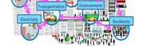
Both sentient and sensual, the smart city is based on the identification of millions of occurrences around the mobility from evaluating residents consumption of water and energy, to recording traffic on road network, to communication network congestion on hot spots, to measure air quality, and tracking public opinions on social networks. This project aims to characterize urban mobility in smart cities, which are interconnected and interdependent sociotechnical systems. Our objectives are:
| ||

|
[[Using Real-Time Traffic Data to Improve Civic Transportation Services]] | |
| This project will expand Chapel Hill’s Data program to incorporate Waze real-time traffic data.
Chapel Hill already uses the OpenDataSoft platform to share public data across the town government and with citizens. This project will allow to the town to quickly and seamlessly collect, harmonize and analyze real-time traffic data through the Waze Connected Citizens Program. The Waze Connected Citizen is a free data exchange program. The OpenDataSoft platform enables the two-way free data exchange between Waze and Chapel Hill and provides tools to analyze the data and compare it with other transportation data already offered by the town. | ||

|
[[V2G Electric School Bus Commercialization Project]] | |
| Project is addressing VTO’s core objective of reducing the cost of PEVs, and VTO’s specific Electrification R&D objective of understanding the potential impacts of EV charging on the nation’s electric grid – in both cases through pioneering V2G technology in heavy-duty vehicles | ||
|
[[Video Analytics for Orlando Public Safety]] | |
| The project will create connected, city-wide mobile resources and systems to help improve the responses to a variety of challenges within the City of Orlando. Orlando is central city of 275,000 people, in an urban area of 2.4 million citizens, but with 68+ million visitors per year and the largest rental car market in the world. Thus, Orlando has some unique challenges with public safety and traffic. This project will meet the needs of several city departments and external agencies by ensuring cross-cutting and robust situational awareness for a variety of scenarios. It will allow for optimized deployments and expedited responses from police, fire fighters, emergency medical services, public works staff, transportation staff, special event managers, and external agencies which are obligated to provide mutual aid. | ||

|
[[Virtual Care Delivery Model to Sustainably Expand the Capacity and Reach of Health Systems to Deliver High-Quality Care in Rural Communities]] | |
Objectives
| ||

|
[[Wabash Heartland Innovation Network - Advancing Agriculture and Manufacturing via IoT]] | |
| The Wabash Heartland Innovation Network (WHIN) is a consortium of 10 counties in north-central Indiana, funded by the Lilly Endowment, devoted to working together to fuel prosperity by harnessing the power of internet-enabled sensors to develop our region into a global epicenter of digital agricultural and next-generation manufacturing. | ||

|
[[Water Application Management]] | |
| Watering the grass is one of those activities that is usually a “set it and forget it” process. But when you have 25 million square feet of landscape under irrigation, you can’t afford to waste a single drop. In our situation 1” of overwatering can cost as much as $40,000 a year.
So we set out to create a computerized “smart system” that operates with very little human intervention and is active and available at all times. This system is able to give directions to the over 456 field controller locations and receive feedback to help calibrate the system only applying what is necessary to keep the plant material healthy and thriving. There are many horticultural aspects that go into keeping landscape healthy. Of these water is among the most critical. Knowing exactly how much water to use is impossible unless you have a way to measure output and monitor system performance. We created a method to do just that. This method is controlled from a central location and can be accessed on tablets in the field. | ||

|
[[Web-based Platform To Quickly Test New Technologies For Cities]] | |
| UrbanLeap empowers cities to test new technologies in an easy and actionable way:
• Enables cities to manage and track the life cycle of pilot projects • Saves staff time by streamlining and automating processes • Supports interdepartmental and intercity collaboration and vendor participation | ||

|
[[West Coast Clean Transit Corridor]] | |
| The West Coast Clean Transit Corridor Initiative is an ongoing, collaborative effort among 16 utilities to support the development of electric vehicle charging facilities along I-5, from San Diego to British Columbia, for heavy- and medium-duty freight haulers and delivery trucks. | ||

|
[[Wilsonville Long-Duration Storage System Demonstration]] | |
| Build a 3 MWh Long-Duration Storage System to demonstrate multiple use cases, including frequency response, contingency reserve, voltage and VAR support, demand response and resource optimization. The project will be located on land adjacent to ESS’ factory headquarters in Wilsonville, Oregon. | ||
|
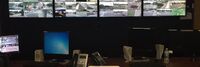
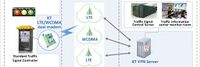
[[Wireless LTE Traffic Signal Control System Using IoT technology for all crossroads in Gunpo-city South Korea]] | |
| The Gunpo City traffic signal system was created with a voluntary idea, based on the experience of operating a traffic information system and with the application of the latest IT technology trend.
Thus, we have prepared a stepping stone for the provision of traffic signal information to the private sector in the era of automated vehicles of the 4th Industrial Revolution which had not felt concrete until now. | ||

|
[[Wireless Living Lab for Smart Agriculture and Rural Communities]] | |
* Establish a wireless living lab at an Iowa State University research farm for cross-domain, cross-discipline research, education, and pilot of smart ag and rural connectivity solutions
| ||

|
[[WiseTown]] | |
| W.I.S.E. Town stands for Web Information Streams Enhancer for your Town. The goal of this solution is to collect information from different streams to identify the issues that affect the city in several areas: urban renewal, garbage collection, public safety, transportation, social services and environmental problems. | ||

|
[[World Digital School]] | |
| Cities and communities around the world are entering the next era of transformational change in which citizens and their surrounding natural and built environments are increasingly connected by digital technologies. In the coming digital industrial revolution, technology will widen the playing field to include greater participation of individuals and ideas from all walks of life as we reinvent who and what we are. These technologies not only have the potential to build a more inclusive community, but when thoughtfully applied could help realize greater socio-economic gains. Conversely, if these technologies are not available to all, we would fragment our communities more than they are today.
Smart Cities are %90 sociology and %10 infrastructure. | ||

|
[[World Smart Sustainable Cities Organization WeGO]] | |
| The World Smart Sustainable Cities Organization (WeGO), established by 50 founding member cities in 2010, is an international association of city and other local governments, smart tech solution providers, and national and regional institutions committed to the transformation of cities into smart sustainable cities.
A diverse range of activities include capacity building programs, sessions and smart city conferences and study visits, feasibility studies and pilot projects, expos and exhibitions, smart city guidelines and best practice catalogs. | ||

|
[[Yachats Resilient Civic Campus Plan]] | |
| A Resilient Civic Campus Planning process was conducted by the City of Yachats to convene the community and consider how renewable power could help prepare for hazard events and leverage improvements supporting community resilience | ||