Portland Connected Intelligent Transportation: Difference between revisions
m 1 revision imported |
No edit summary |
||
| Line 6: | Line 6: | ||
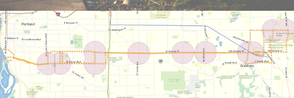
| imagecaption = Above: Portland Skyline, Below: Powell-Division corridor | | imagecaption = Above: Portland Skyline, Below: Powell-Division corridor | ||
| municipalities = [https://www.portlandoregon.gov/bps/ Portland Bureau of Planning and Sustainability], [https://en.wikipedia.org/wiki/Porto Porto Portugal]--> | | municipalities = [https://www.portlandoregon.gov/bps/ Portland Bureau of Planning and Sustainability], [https://en.wikipedia.org/wiki/Porto Porto Portugal]--> | ||
| team = Intel, NetCity, | | team = Intel, NetCity, Urban.Systems, OpenBike, DKS, Seabourne, Sera Architects, Urbi, UbiWhere, Mobility Cubed, InterInnov, Technical University Madrid | ||
| leader = Skip Newberry | | leader = Skip Newberry | ||
| image = PortlandSmartTransport.png | | image = PortlandSmartTransport.png | ||
| imagecaption = Above: Portland Skyline, Below: Powell-Division corridor | | imagecaption = Above: Portland Skyline, Below: Powell-Division corridor | ||
| municipalities = Portland | | municipalities = Portland OR | ||
<!--Bureau of Planning and Sustainability, Porto Portugal--> | <!--Bureau of Planning and Sustainability, Porto Portugal--> | ||
| status = Implemented | | status = Implemented | ||
Revision as of 06:07, November 15, 2021
| Portland Connected Intelligent Transportation | |
|---|---|

| |
 Above: Portland Skyline, Below: Powell-Division corridor | |
| Team Organizations | Intel NetCity Urban.Systems OpenBike DKS Seabourne Sera Architects Urbi UbiWhere Mobility Cubed InterInnov Technical University Madrid |
| Team Leaders | Skip Newberry |
| Participating Municipalities | Portland OR |
| Status | Implemented |
| Document | [[File:Sensor Network Recommendation|Download]] |
Description
This project focuses on developing a sensor-connected “smart” corridor in Portland where transit data, traffic signalization, and air quality sensing are made available in a data portal with data visualization and analytics to improve transportation options, public health, economic development and civic engagement.
Challenges
Achieving adequate density, frequency, and precision of environmental sensor measurements to model pollution spatial distributions and the effects of mitigation strategies on pollutant concentrations with a limited budget for sensors.
Solutions
- Calibrate air quality sensors by deploying at one intersection and co-locating with high quality reference instruments
- Evaluate density, frequency, and precision of sensor measurements to secure sufficient data quality to model particulate and gaseous pollutant distributions
- Deploy at a sufficient number of junctions to model air pollution on the corridor
- Deploy across the city
- Share what is learned about sensor performance and quality control procedures developed with other cities to improve deployments of low cost air quality sensors
Major Requirements
NA
Performance Targets
| Key Performance Indicators (KPIs) | Measurement Methods |
|---|---|
|
>5% reduction in the following pollutants CO, NO2, PM2.5 |
|
Standards, Replicability, Scalability, and Sustainability
The project will explore the use of FIWARE, a set of tools and libraries with public and open-source specifications and interfaces. FIWARE is contributing to the International Technical Working Group on IoT-Enabled Smart City Framework launched by NIST. FIWARE brings the NGSI standard API which represents a pivot point for Interoperability and Portability of smart city applications and services.
Cybersecurity and Privacy
Portland Mayor's office has been working with sensor providers to define the privacy and security requirements of IOT contracts. Defining data as 'Raw' and 'Delivered' Portland will ensure that all future IOT contracts state what data must be delivered to the city under the terms of the contract 'Delivered' and this data will be owned by the city and where it does not violate privacy concerns will be shared with citizens under the cities open data policies. Further any other data collected in the process of creating the delivered data called 'Raw' data must be destroyed by the vendor and not used for any commercial purpose. This project is now exploring ways in which such contracts can be enforced in code at the sensor.
Impacts
There is a large and growing need for low cost environmental sensors which is emerging technology. The development and evaluation of new low cost sensor packages will support regional economic growth and provide new knowledge about sensor performance so that deployments across any city can ensure the use of sensors and better data quality to improve health and environmental quality.
Demonstration/Deployment
- Phase I Pilot/Demonstration, June 2016: Calibrate air quality sensors by deploying at one intersection and co-locating with high quality reference instruments.
- Phase II Deployment, June 2017: Evaluate density, frequency, and precision of sensor measurements to secure sufficient data quality to model particulate and gaseous pollutant distributions.