Semantic search
Jump to navigation
Jump to search
|
[[Applying Open Data to inform future Smart City Design]] | |
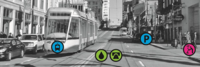
In order for cities and design professionals to have a more transparent understanding of the Climate Change impacts of potential building development, they must have a tool that provides quick and facile real time calculation linked to the weather data and utility information of an area, along with the potential energy usage. Between March 2016 and 2017:
| ||

|
[[BigClouT]] | |
BigClouT project aims at giving an analytic capability to cities exploiting available big data from sources such as IoT devices, open data, social networks, mobile applications, etc. and use them to improve the daily life of cities, their citizens and visitors. The target applications are:
| ||

|
[[Building an Open Data Ecosystem]] | |
| The "Building an Open Data Ecosystem" project in Leeds, United Kingdom aims to foster collaboration and innovation through the development of an open data ecosystem in the city. | ||
|
[[CITYDASH City-wide analytics dashboard from public and private data sources]] | |
Data analytics and insights powered by machine intelligence for 4 target city departments:
| ||
|
[[CIVIC Data Platform]] | |
| CIVIC is an open data platform to democratize
public information and drive meaningful engagement through neutral, nonpartisan analytics. It's built entirely by multidisciplinary teams of volunteer coders, designers and domain experts using open source technology. | ||

|
[[Central Data Management System]] | |
| The 'Central Data Management System' project in Vienna, Austria aims to establish a comprehensive and efficient data management framework for the city. Led by the City of Vienna's Department of Data Management, the project seeks to centralize data storage, ensure data quality and security, and streamline data access and sharing processes. | ||

|
[[Citizen App]] | |
| Citizen App, the first of its kind, empower individuals to claim and legally own their data from across multiple sources, then use it securely and seamlessly in everyday life. | ||
|
[[City Insight Platform- Communities in Context]] | |
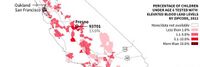
| Using data from the city, state and federal level Vizalytics will create a City Insight Platform.
This will provide users with a real-time view of what is happening in a neighborhood, and can be refined by choosing which lens to view- from socio-economic indices, business climate, transportation, infrastructure, quality of life and more. | ||
|
[[Combating Urban Blight in the New York Capital Region and Mohawk Valley]] | |
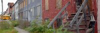
| Urban blight is a city and regional level problem that impacts social and economic opportunities, among others, of those who live and work in cities. This project is focused on piloting a shared policy, management, and technology infrastructure that will allow four cities within the NYS capital region to share information about properties in a way that enables new insights into and action focused on urban blight. With funding from the NYS Department of State, the Cities of Schenectady, Troy, Amsterdam, and Gloversville have partnered with the Center for Technology in Government (CTG), University at Albany, to develop the technical, policy, and organizational capabilities needed within and across the cities to interrupt the cycle of blight in their communities. The results of the pilot will be made available for application regionally and statewide. Future work will include integrating additional data types (e.g. video) and sources (e.g. sensor technologies). | ||
|
[[Constituent-led Public Data and IoT Utility for Urban Health Housing and Environmental Hazard Management]] | |
Objectives
| ||

|
[[Coral Gables Smart City Hub Public Platform]] | |
| The City of Coral Gables promotes the development of a smart city ecosystem that fosters innovation by bringing together through technology People, Businesses, Organizations, Things, and Systems. By leveraging strategic planning and innovation, the City’s digital transformation and smart initiatives can benefit our citizens with continual improvement to customer service and quality of life. Our smart city plan implements several interconnected and interoperable elements that include a Smart City Hub, Data Platforms, Internet of Things, and a robust and resilient technology infrastructure with high-speed communications. | ||
| [[Data.gov]] | ||
| Data.gov is a website operated by the U.S. federal government that provides access to datasets and other resources related to government activities and policies. It is intended to make government data more easily accessible to the public, with the goal of increasing transparency and enabling citizens to better understand and engage with their government. Data.gov offers a wide variety of data sets and resources, including data on topics such as agriculture, education, energy, finance, health, and more. The website also includes tools and resources for developers, such as APIs and code libraries, to help people use the data in creative and innovative ways. | ||
|
[[Decision Theatre PSU]] | |
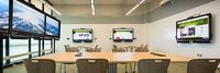
| Portland State University’s Decision Theater is designed for university researchers and regional stakeholders (i.e. government, private companies) to work on projects that “link data sets, visualization and decisions,” according to a university statement. The space is modeled after Arizona State University's Decision Theater, as well as a similar facility at the University of Chicago. | ||

|
[[DigiTel Resident Card]] | |
| The City of Tel Aviv has undergone a transformation to become a “smart city” that uses technology to improve the City Hall administration and its citizens’ lives. Through programs such as the DigiTel Residents Club and the DigiTel mobile application, Tel Aviv offers innovative electronic services to its population and is searching ways to make citizens interested in how the city works. Throughout the process, Tel Aviv has worked closely with Microsoft to find the best ways to achieve its vision of a smart city. | ||
|
[[Digital Strategy Borchen-Etteln]] | |
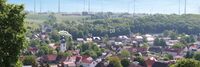
| To further increase the quality of life for all people in Borchen-Etteln and to develop the economic, social and ecological potential. In doing so, we take into account the interests of all age groups | ||
|
[[Digital Twin: Infectious Disease Management]] | |
| Link time, spatial and sensor data with existing enterprise data to enable new insights. | ||

|
[[Digital Twin: Manufacturing Quality Control Via Remote Operator]] | |
| The post-Covid world necessitates remote verification of manufacturing components – in real-time, as they are conveyed across the manufacturing line. | ||

|
[[Dwellingly]] | |
| Dwelling.ly is an app to improve communication between the landlord providing transitional housing and the social workers who support them. | ||
|
[[Emergency Communication Services]] | |
| Establishes a practical approach for management of emergency and incident response with a common operating picture. | ||

|
[[Estimation of De Facto Population]] | |
Key Deliverables
| ||