Underground Infrastructure Sensing and Mapping: Difference between revisions
Jump to navigation
Jump to search
No edit summary |
No edit summary |
||
| (3 intermediate revisions by the same user not shown) | |||
| Line 1: | Line 1: | ||
{{ActionCluster | {{ActionCluster | ||
|image=Mapping Underground Infrastructure.jpeg | |image=Mapping Underground Infrastructure.jpeg | ||
|team=BTV Ignite, Kardinal Microsystems, University of Vermont | |team=BTV Ignite, Kardinal Microsystems, University of Vermont | ||
|leader=Dryver Huston | |leader=Dryver Huston, Tian Xia | ||
|imagecaption=Mapping Underground Infrastructure | |imagecaption=Mapping Underground Infrastructure | ||
|municipalities=Winooski VT | |municipalities=Winooski VT | ||
|status=Development | |||
|description=Use sensing and information technology to determine the state of infrastructure and provide it in an appropriate, timely and secure format for the managers, planners and users. Information processing techniques convert the data in information-laden databases for use in analytics, graphical presentations, metering and planning. | |description=Use sensing and information technology to determine the state of infrastructure and provide it in an appropriate, timely and secure format for the managers, planners and users. Information processing techniques convert the data in information-laden databases for use in analytics, graphical presentations, metering and planning. | ||
|challenges=* Technical challenges for sensor selection, design, operation and use. Subsurface congestion and unknown features are complications. | |challenges=* Technical challenges for sensor selection, design, operation and use. Subsurface congestion and unknown features are complications. | ||
* Information processing challenges to convert sensor data into database of subsurface mapping and condition. | * Information processing challenges to convert sensor data into database of subsurface mapping and condition. | ||
* Communication, management and interoperability – multiple utilities, some span neighboring municipalities: water, sewer (sanitary and stormwater), electric, gas, and telecommunications ; have different features, protocols and management issues. | * Communication, management and interoperability – multiple utilities, some span neighboring municipalities: water, sewer (sanitary and stormwater), electric, gas, and telecommunications ; have different features, protocols and management issues. | ||
|solutions=Digital Twin | |||
|requirements=# Develop map of underground utilities using ground penetrating radar, pipe robot telemetry, new construction observations and historical records; using combination of constructive, pattern recognition and data fusion methods. | |requirements=# Develop map of underground utilities using ground penetrating radar, pipe robot telemetry, new construction observations and historical records; using combination of constructive, pattern recognition and data fusion methods. | ||
# Place condition and operation sensors into underground infrastructure at key locations. | # Place condition and operation sensors into underground infrastructure at key locations. | ||
| Line 37: | Line 39: | ||
# System performance assessment. | # System performance assessment. | ||
# Study of scalability. | # Study of scalability. | ||
|chapter=Digital Twins | |||
|supercluster=Utility | |supercluster=Utility | ||
|year=2016, 2017 | |year=2016, 2017 | ||
Latest revision as of 06:18, January 25, 2023
| Underground Infrastructure Sensing and Mapping | |
|---|---|

| |
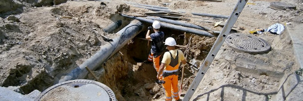
 Mapping Underground Infrastructure | |
| Team Organizations | BTV Ignite Kardinal Microsystems University of Vermont |
| Team Leaders | Dryver Huston Tian Xia |
| Participating Municipalities | Winooski VT |
| Status | Development |
| Document | None |
Description
Use sensing and information technology to determine the state of infrastructure and provide it in an appropriate, timely and secure format for the managers, planners and users. Information processing techniques convert the data in information-laden databases for use in analytics, graphical presentations, metering and planning.
Challenges
- Technical challenges for sensor selection, design, operation and use. Subsurface congestion and unknown features are complications.
- Information processing challenges to convert sensor data into database of subsurface mapping and condition.
- Communication, management and interoperability – multiple utilities, some span neighboring municipalities: water, sewer (sanitary and stormwater), electric, gas, and telecommunications ; have different features, protocols and management issues.
Solutions
Digital Twin
Major Requirements
- Develop map of underground utilities using ground penetrating radar, pipe robot telemetry, new construction observations and historical records; using combination of constructive, pattern recognition and data fusion methods.
- Place condition and operation sensors into underground infrastructure at key locations.
- Use fiber optic high-speed telecommunications network to transmit data.
- Create Underground Infrastructure Information Model database for use in infrastructure management and planning.
- Integrate cybersecurity measures into design decisions.
Performance Targets
| Key Performance Indicators (KPIs) | Measurement Methods |
|---|---|
|
Billing records, service records, and sewer sensing |
Standards, Replicability, Scalability, and Sustainability
- The sensing systems, data streams, and databases can all easily conform to existing and emerging standards.
- The initial deployment is in a small city that is big enough to capture many of the pertinent issues, yet small enough to allow degrees of freedom for easy deployment. Conceptual and technical development then easily scales to bigger cities.
Cybersecurity and Privacy
TBD
Impacts
- Overall more efficient and resilient subsurface infrastructure
- Reduced service outages and emergency repairs
- Better planning tools
- Reduced environmental impacts – energy use, and stormwater and sewage discharge.
- Quicker construction cycles.
Demonstration/Deployment
- Phase I Pilot/Demonstration:
GPR measurement and integration of historical records to construct UIIM database for one or two city blocks
- Phase II Deployment:
- Selection of best deployment sites.
- Construct database using tomographic GPR, construction and historic records.
- Integration of sensors into telecommunications (fiber optic) system.
- Database usage and demonstration, including mobile apps.
- Cybersecurity integration.
- System performance assessment.
- Study of scalability.