Tsukuba Japan

- Members
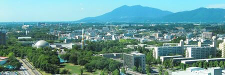
Tsukuba is a city located in Ibaraki Prefecture, Japan. As of 1 July 2020, the city had an estimated population of 244,528 in 108,669 households and a population density of 862 persons per km². The percentage of the population aged over 65 was 20.3%. The total area of the city is 283.72 square kilometres (109.54 sq mi). It is known as the location of the Tsukuba Science City, a planned science park developed in the 1960s.
Activities

|
BigClouT | |
BigClouT project aims at giving an analytic capability to cities exploiting available big data from sources such as IoT devices, open data, social networks, mobile applications, etc. and use them to improve the daily life of cities, their citizens and visitors. The target applications are:
| ||
Details
Tsukuba is located in southern Ibaraki Prefecture, approximately 50 kilometers from central Tokyo and about 40 kilometers from Narita International Airport. Mount Tsukuba, from which the city takes its name is located in the northern part of the city. Except for the area around Mount Tsukuba, the city is a part of the Kantō Plain with an altitude of 20 to 30 meters.
Mountains: Mount Tsukuba, Mount Hokyo.
Rivers: Kokai River, Sakura River, Higashiyata River, Nishiyata River, Ono River, Hanamuro River, Inari River.
Parks: The city has more of 100 parks and green areas to relax. Different parks are connected by pedestrian walk and bikeways, some parks has equipped with tennis courts and round pavements for jogging and walking. Doho Park, is a park surrounded by vegetation centered in Doho Swamp, has a baseball field, a soccer field, a gym and a heated indoor pool equipped with solar heating system. Matsumi Park, has a 45m height of observation tour and a Japanese style garden with flowers and a small pond.
Gardens: Tsukuba Botanical Garden and Tsukuba Peony Garden.
In the extreme south is the Ushiku Lagoon; the Nishiyata, Higashiyata and Inari rivers discharge their waters into it. The Ushiku Lagoon through the Yata River, flows into the Kokai River.
At the end of their courses, the Kokai River discharge into the Tone River, and the Sakura, Hanamuro and Ono rivers discharge into the Lake Kasumigaura.
- History
Mount Tsukuba has been a place of pilgrimage since at least the Heian period. During the Edo period, parts of what later became the city of Tsukuba were administered by a junior branch of the Hosokawa clan at Yatabe Domain, one of the feudal domains of the Tokugawa shogunate. With the creation of the modern municipalities system after the Meiji Restoration on April 1, 1889, the town Yatabe was established within Tsukuba District, Ibaraki.
Beginning in the 1960s, the area was designated for development. Construction of the city centre, the University of Tsukuba and 46 public basic scientific research laboratories began in the 1970s. Tsukuba Science City became operational in the 1980s. The Expo '85 world's fair was held in the area of Tsukuba Science City, which at the time was still divided administratively between several small towns and villages. Attractions at the event included the 85-metre (279 ft) Technocosmos, which at that time was the world's tallest Ferris wheel.
On November 30, 1987 the town of Yatabe merged with the neighboring towns of Ōho and Toyosato (from Tsukuba District)) and the village of Sakura (from Niihari District) to create the city of Tsukuba. The neighboring town of Tsukuba merged with the city of Tsukuba on January 1, 1988. Followed by the town of Kukizaki (from Inashiki District) on November 1, 2002. Therefore, Yatabe, Ōho, Toyosato, Sakura, Tsukuba and Kukizaki, correspond to the ancient towns and villages.
By 2000, the city's 60 national research institutes and two national universities had been grouped into five zones: higher education and training, construction research, physical science and engineering research, biological and agricultural research, and common (public) facilities. These zones were surrounded by more than 240 private research facilities. Among the most prominent institutions are the University of Tsukuba (1973; formerly Tokyo University of Education); the High Energy Accelerator Research Organization (KEK); the National Institute of Advanced Industrial Science and Technology; the Electrotechnical Laboratory; the Mechanical Engineering Laboratory; and the National Institute for Materials Science. The city has an international flair, with about 7,500 foreign students and researchers from as many as 133 countries living in Tsukuba at any one time.
Over the past several decades, nearly half of Japan's public research and development budget has been spent in Tsukuba. Important scientific breakthroughs by its researchers include the identification and specification of the molecular structure of superconducting materials, the development of organic optical films that alter their electrical conductivity in response to changing light, and the creation of extreme low-pressure vacuum chambers. Tsukuba has become one of the world's key sites for government-industry collaborations in basic research. Earthquake safety, environmental degradation, studies of roadways, fermentation science, microbiology, and plant genetics are some of the broad research topics having close public-private partnerships.
On April 1, 2007 Tsukuba was designated a Special city with increased autonomy.
Following the Fukushima I nuclear accidents in 2011, evacuees from the accident zone reported that municipal officials in Tsukuba refused to allow them access to shelters in the city unless they presented certificates from the Fukushima government declaring that the evacuees were "radiation free".
On May 6, 2012, Tsukuba was struck by a tornado that caused heavy damage to numerous structures and left approximately 20,000 residents without electricity. The storm killed one 14-year-old boy and injured 45 people. The tornado was rated an F-3 by the Japan Meteorological Agency, making it the most powerful tornado to ever hit Japan. Some spots had F-4 damage.