Salem OR


- Members


Salem is the capital of the U.S. state of Oregon, and the county seat of Marion County. It is located in the center of the Willamette Valley alongside the Willamette River, which runs north through the city. The river forms the boundary between Marion and Polk counties, and the city neighborhood of West Salem is in Polk County. Salem was founded in 1842, became the capital of the Oregon Territory in 1851, and was incorporated in 1857.
Activities

|
Electric Truck Charging Depot in Salem | |
| WattEV is planning to build an electric truck charging depot in Salem, Oregon, off Interstate 5, with the capacity to power approximately 40,000 trucks annually. | ||
|
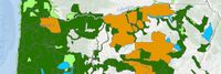
GIS Resources from the Oregon Department of Forestry | |
| Oregon Department of Forestry's GIS Data is maintained by the Information Technology Department's GIS Unit. | ||
|
Oregon Data Catalog | |
| The Oregon Data Catalog is a platform for managing and publishing data sets that are relevant to the state of Oregon in the United States. The platform is based on CKAN, which is a free and open-source software platform for managing and publishing data. | ||

|
Oregon Streetlight Conversion Project Reaches Completion | |
| A leading cleantech integrator specializing in energy efficiency and renewable energy, today announced the completion of its streetlight conversion pilot program with the Oregon Department of Transportation (ODOT). The $18.6 million project was funded by an energy savings performance contract (ESPC) and replaced more than 8,000 high-pressure sodium lighting fixtures across the greater Portland area with LEDs. Ameresco also upgraded lighting in 13 tunnels within ODOT Region 1. | ||
Details
Salem had a population of 174,365 in 2019,[6] making it the third-largest city in the state after Portland and Eugene. Salem is the principal city of the Salem Metropolitan Statistical Area, a metropolitan area that covers Marion and Polk counties[7] and had a combined population of 390,738 at the 2010 census. A 2019 estimate placed the metropolitan population at 400,408, the state's second largest.[8] This area is, in turn, part of the Portland-Vancouver-Salem Combined Statistical Area.
The city is home to Willamette University, Corban University, and Chemeketa Community College. The State of Oregon is the largest public employer in the city, and Salem Health is the largest private employer. Transportation includes public transit from Cherriots (legally known as Salem Area Mass Transit District), Amtrak service, and non-commercial air travel at McNary Field. Major roads include Interstate 5, Oregon Route 99E, and Oregon Route 22, which connects West Salem across the Willamette River via the Marion Street and Center Street bridges.