| Shirahama Japan
|
|
|
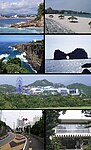
| Top left: Nanki Shirahama Spa, Top right: Shirahama Beach, 2nd left: Three-stage Wall (Sandanheki), 2nd right: Engetsu Island (Engetsuto), 3rd: Shirahama Adventure World, Bottom left: Tsubaki Spa, Bottom right: Minakata Kumagusu Memorial Museum
|
|
|
|
|
| Seal
|
Loading map... {"minzoom":false,"maxzoom":false,"mappingservice":"leaflet","width":"450px","height":"250px","centre":false,"title":"","label":"","icon":"","lines":[],"polygons":[],"circles":[],"rectangles":[],"copycoords":false,"static":false,"zoom":10,"defzoom":14,"layers":["OpenStreetMap"],"image layers":[],"overlays":[],"resizable":false,"fullscreen":false,"scrollwheelzoom":true,"cluster":false,"clustermaxzoom":20,"clusterzoomonclick":true,"clustermaxradius":80,"clusterspiderfy":true,"geojson":"","clicktarget":"","imageLayers":[],"locations":[{"text":"\u003Cb\u003E\u003Cdiv class=\"mw-parser-output\"\u003E\u003Cp\u003EShirahama Japan\n\u003C/p\u003E\u003C/div\u003E\u003C/b\u003E\u003Cdiv class=\"mw-parser-output\"\u003E\u003Cp\u003EShirahama Japan\n\u003C/p\u003E\u003C/div\u003E","title":"Shirahama Japan\n","link":"","lat":33.6779962,"lon":135.3669663,"icon":""}],"imageoverlays":null} |
| Shirahama Japan Map
|
| Type of Municipality
|
Town
|
| Date Established
|
April 1, 1889
|
| Area
|
77.60 sq.mi200.983 sq.km <br />49,664 Acres <br />
|
| Elevation
|
108 ft32.918 m <br />
|
| Population
|
20,70420,704 people <br />
|
| Timezone
|
UTC+9
|
- Members
Shirahama is a town in Nishimuro District, Wakayama Prefecture, Japan. As of 31 October 2021, the town had an estimated population of 20,704 in 11024 households and a population density of 100 persons per km².[1] The total area of the town is 200.98 square kilometres (77.60 sq mi).
Activities

|
|
NerveNet: Regional Resilient IoT Platform
|
Project Description Points
- Shirahama is a town on the Pacific coast having a beautiful beach, attracting more than three million tourists. Nearly 10 % are inbound, demanding free Wi-Fi Internet service. It has been promoting “Work in Shirahama”.
- Shirahama, on the other hand, has to prepare for earthquakes and tsunamis because it is officially said the probability of a large, M8-M10 class earthquake occurring within 30 years is approximately 70%.
- The project aims at clarifying the effectiveness of a resilient communication platform called NerveNet, developed by NICT, which provides resilient local communication as well as connectivity to the Internet.
|
|
|
Details