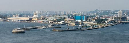
Fujisawa Japan
- Members
Fujisawa is a city in Kanagawa Prefecture, Japan. As of 1 June 2021, the city had an estimated population of 439,728 and a population density of 6300 persons per km².[1] The total area of the city is 69.57 square kilometres (26.86 sq mi).
Activities

|
BigClouT | |
BigClouT project aims at giving an analytic capability to cities exploiting available big data from sources such as IoT devices, open data, social networks, mobile applications, etc. and use them to improve the daily life of cities, their citizens and visitors. The target applications are:
| ||
Details
Fujisawa is in the central part of Kanagawa Prefecture. It faces Sagami Bay of the Pacific Ocean. The northern part of the city is on the Sagamino plateau while the southern part is on the Shonan Dunes.
Fujisawa has three major topographical features: the island of Enoshima to the south connected to the Katase shoreline area by a road bridge, and two rivers, the Hikiji and the Sakai, which run north-south. The Hikiji can be traced from an area designated as a nature reserve park in the city of Yamato and flows directly along the boundary of the joint US Navy and Japan Maritime Self-Defense Force Atsugi Naval Air Base and the United States Army Camp Zama. The Sakai runs directly from the mountains between Machida and Hachiōji, and for quite some distance forms the border between the Tokyo Metropolitan Area and Kanagawa Prefecture. From Machida city centre, the river can be directly followed by a foot and cycle path to Fujisawa city centre, a distance of approximately 35 km (22 mi). Another cycle path runs along the Shonan Coastal path, from the Sagami River, in Hiratsuka, to Enoshima Bridge in Fujisawa.
- History
The area around present-day Fujisawa City has been inhabited for thousands of years. Archaeologists have found stone tools and shell middens from the Japanese Paleolithic period, ceramic shards from the Jōmon period, and graves from the Kofun period at numerous locations. The area is mentioned in the Nara period Nihon Shoki chronicles. By the Heian period, central Sagami Province was divided into shōen controlled by the Muroaoka, Oe, and other local warlords. During the Kamakura period, Fujisawa was the setting for a number of battles to overthrow the Kamakura shogunate as mentioned in the late 14th century Taiheiki. During the Muromachi period, Fujisawa developed around Yugyo-ji, a Buddhist temple, which was established in 1325.
With the Edo period, Fujisawa prospered as Fujisawa-shuku, a post station on the Tōkaidō highway connecting Edo with Kyoto. Shōgun Tokugawa Ieyasu built a palace in Fujisawa as a rest stop between Edo and Sunpu.
Following the Meiji Restoration, the area was divided into villages in Kōza District and Kamakura District within Kanagawa Prefecture. The Kōza District office was located in Fujisawa from 1878. The area developed rapidly after the opening of Fujisawa Station of Tōkaidō Main Line in 1887.
During the cadastral reform of April 1, 1889, Fujisawa-Ōsaka Town (in Kōza District) and Fujisawa-Ōtomi Town (in Kamakura District) were created through the merger of local hamlets. Emperor Meiji visited Fujisawa in 1891 to watch military maneuvers. The IJA 49th Infantry Regiment under the IJA 1st Division was stationed in Fujisawa from 1907. During the same year, Fujisawa-Ōsaka Town absorbed Fujisawa-Ōtomi Town and expanded further in 1908 by annexing the neighboring villages of Kugenuma and Meiji (both from Kamakura District), renaming itself Fujisawa Town.
The 1923 Great Kantō earthquake caused severe damage to Fujisawa, with some 4,000 houses destroyed. An Imperial Japanese Navy Artillery School was established in Tsujido in 1926.
The town of Fujisawa was elevated to city status on October 1, 1940. Fujisawa expanded by annexing the village of Muraoka in 1941, the village of Mutsuai in 1942, the town of Katase in 1947, and the villages of Goshomi, Chogo, Takakura and parts of Koide (hamlet of Endo) in 1955. Fujisawa hosted the yachting events of the 1964 Summer Olympics.
These improved transport links, such as the Yokohama Subway line and express train services on the Odakyu line, have made Fujisawa an increasingly attractive and cost-effective commuter suburb for Tokyo and Yokohama.

