Air Quality Monitoring in London: Difference between revisions
Jump to navigation
Jump to search
No edit summary |
No edit summary |
||
| (5 intermediate revisions by the same user not shown) | |||
| Line 4: | Line 4: | ||
|leader=Mathieu Carlier | |leader=Mathieu Carlier | ||
|imagecaption=Air Pollution Monitoring Station | |imagecaption=Air Pollution Monitoring Station | ||
|municipalities=Greenwich | |municipalities=Greenwich UK | ||
|status=Launched | |status=Launched | ||
|website=http://www.everimpact.org/ | |website=http://www.everimpact.org/ | ||
|description=Key Deliverables | |description=Key Deliverables | ||
* IoT platform that measures air pollutants and greenhouse gases in London, in real-time, by combining ground sensors and satellites’ data | * IoT platform that measures air pollutants and greenhouse gases in London, in real-time, by combining ground sensors and satellites’ data | ||
| Line 37: | Line 36: | ||
* Quality of Life improved for citizens | * Quality of Life improved for citizens | ||
|demonstration=Real-time working application showing air pollution of London city on a map. | |demonstration=Real-time working application showing air pollution of London city on a map. | ||
|chapter=Physical Health | |||
|supercluster=Transportation | |supercluster=Transportation | ||
|year=2016, 2017 | |year=2016, 2017 | ||
|title=Air Quality Monitoring in London | |title=Air Quality Monitoring in London | ||
}} | }} | ||
Latest revision as of 20:26, January 24, 2023
| Air Quality Monitoring in London | |
|---|---|

| |
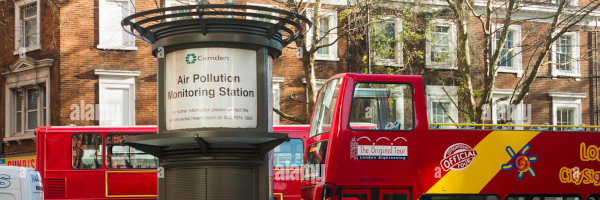
 Air Pollution Monitoring Station | |
| Team Organizations | London Greenwich Borough (City Council and Digital Greenwich) GSMA (Association of Mobile Operators) Everimpact (Solution/Service Provider) Ordnance Survey (UK Mapping Agency) Telefonica (Telco) NEC (Service Provider) Urban Clouds (Service Provider) |
| Team Leaders | Mathieu Carlier |
| Participating Municipalities | Greenwich UK |
| Status | Launched |
| Document | None |
Description
Key Deliverables
- IoT platform that measures air pollutants and greenhouse gases in London, in real-time, by combining ground sensors and satellites’ data
- Real-Time monitoring and mapping of air pollution in London
- Monetizing reductions of Carbon Emissions to generate revenues and/or debt financing for the London Greenwich’s Borough
Challenges
- Cities lack the tools to monitor accurately air pollution, and do not leverage revenues or financing that can be drawn from carbon offsetting
- The project will deploy and capture data from sensors positioned in the city of London (fixed and mobile sensors on bicycles and vehicles), and combine it with satellite data, in order to map precisely air pollution. The project will also test the generation of revenues from offsetting CO2 emissions from a London Tube Power Station.
Solutions
TBD
Major Requirements
- Create scope and requirements, project plan
- Develop system architecture
- Roll out pilot in London (Greenwich Borough)
- Run pilot for 1 year (April 2017- April 2018)
- Build application/demo for showcases
Performance Targets
| Key Performance Indicators (KPIs) | Measurement Methods |
|---|---|
|
|
Standards, Replicability, Scalability, and Sustainability
- Establish and standardize the most accurate air pollution data measurement methodology
- Standardization of data protocols among smart cities by using the NGSI standard (FIWARE Open Source)
- The developed standards, methodology, and processes are not unique to 1 city or region and can be replicated and scaled up in multiple cities/communities. The solution is being replicated in Paris, France and has already been chosen to monitor air pollution in 100 cities/projects worldwide by US Foundation R20.
- The system will have its own business model to create sustainable revenue streams.
Cybersecurity and Privacy
TBD
Impacts
- Cleaner Air
- Improved Mapping
- Revenues from Air Pollution
- New products
- Quality of Life improved for citizens
Demonstration/Deployment
Real-time working application showing air pollution of London city on a map.