Yachats OR

- Members
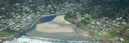
Yachats is a small coastal city in the southernmost area of Lincoln County, Oregon, United States. According to Oregon Geographic Names, the name comes from the Siletz language and means "dark water at the foot of the mountain". There is a range of differing etymologies. William Bright says the name comes from the Alsea placename yáx̣ayky (IPA: /ˈjaχajkʲ/). At the 2020 census, the city's population was 994.
Activities

|
Yachats Resilient Civic Campus Plan | |
| A Resilient Civic Campus Planning process was conducted by the City of Yachats to convene the community and consider how renewable power could help prepare for hazard events and leverage improvements supporting community resilience | ||
Details
Archeological studies have shown that the Yachats area has been inhabited for at least 1,500 years. Remains of a pit-house in Yachats have been radiocarbon dated at approximately 570 AD. Yachats is built on seashell middens and numerous graves left by its past inhabitants. Excavations for construction of buildings and U.S. Route 101 uncovered a great many skeletons and artifacts. Most of these became part of the fill dirt forming the base of the current highway and city.
For many centuries the Native Americans in this area were hunter-gatherers who migrated between summer camps and winter residences. The Alsea Tribe had as many as 20 permanent villages (used on an annually rotating basis) on the Alsea River and the central Oregon coast. Archeological and linguistic evidence support the existence of a southern Alsea village known as the Yahuch band, located on the coast at the Yachats River. By 1860, the Yahuch band was extinct, many having succumbed to European diseases such as smallpox and tuberculosis.
In order to open up land in the Coos Bay area for homesteading in the early 1860s, the U.S. Army forcibly marched the Coos and Lower Umpqua Indians 80 miles (130 km) north over rugged terrain to the Alsea Sub-Agency reservation in Yachats where the peaceful Indians, treated by the Army as though they were prisoners of war, were incarcerated. Amanda's Trail, named for a blind Indian woman who suffered greatly on the march, was dedicated on July 19, 2009. The trail climbs 800 feet (240 m) from downtown Yachats to the summit of Cape Perpetua where it links with the extensive trail system of the Siuslaw National Forest.