Vanport OR
- Members
Vanport, sometimes referred to as Vanport City or Kaiserville,[1] was a city of wartime public housing in Multnomah County, Oregon, United States, between the contemporary Portland city boundary and the Columbia River. It was destroyed in the 1948 Columbia River flood and not rebuilt. It sat on what is currently the site of Delta Park and the Portland International Raceway.
Activities
|
Regenerative Urbanism Vanport | |
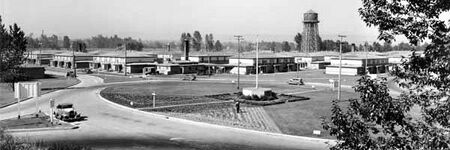
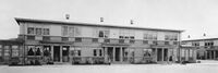
| Vanport, Oregon was a temporary housing project built in 1942 to address a wartime housing shortage in Portland. | ||
Details
Vanport construction began in August 1942 to house the workers at the wartime Kaiser Shipyards in Portland and Vancouver, Washington. Vanport—a portmanteau of "Vancouver" and "Portland"—was home to 40,000 people, about 40 percent of them African-American, making it Oregon's second-largest city at the time, and the largest public housing project in the nation. After the war, Vanport lost more than half of its population, dropping to 18,500, as many wartime workers left the area. However, there was also an influx of returning World War II veterans. In order to attract veterans and their families, the Housing Authority of Portland opened a college named the Vanport Extension Center;[3] the school would eventually be renamed Portland State University.[4]
Vanport was dramatically destroyed at 4:05 p.m. on May 30, 1948, when a 200-foot (60 m) section of a railroad berm holding back the Columbia River collapsed during a flood, killing 15 people. The city was underwater by nightfall, leaving 17,500 of its inhabitants homeless.