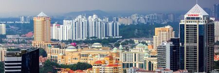
Subang Jaya Malaysia
- Members
Subang Jaya is a city in Petaling District, Selangor, Malaysia. It comprises the southern third district of Petaling. It consists of the neighbourhoods from SS12 to SS19, UEP Subang Jaya (USJ), Putra Heights, Batu Tiga as well as PJS7, PJS9 and PJS11 of Bandar Sunway, the latter of which are partially jurisdictional within Petaling Jaya under the MBPJ. The city is governed by Subang Jaya City Council (MBSJ), which also governs other areas of the Petaling district, such as Puchong and Seri Kembangan. According to Subang Jaya City Council, Subang Jaya has a population of 968,930 in 2020, which makes it the sixth largest city in Malaysia by population.
Activities

|
CheckD Data Wallet: Eat2Give | |
| The EAT2GIVE project in Subang Jaya, Malaysia, leverages the CheckD Data Wallet to unite food lovers, local businesses, and charities in a unique fundraising initiative. By claiming the EAT2GIVE campaign badge on their CheckD wallets, food enthusiasts can support local causes every time they purchase designated menu items at participating food merchants, who pledge RM3 per validation to charity. This innovative campaign promotes community engagement and philanthropy while maintaining user privacy, enabling merchants to boost foot traffic cost-effectively, and providing organizers with seamless validation and transparent reporting. Driven by a partnership between Dataswyft, SubangFood, and TheBFG.team, EAT2GIVE fosters a culture of doing good through commerce, connecting residents and businesses in a shared purpose to strengthen the Subang Jaya community.
'"`UNIQ--item-1093--QINU`"' | ||
Details
Before 1974, what is today Subang Jaya was part of Klang District.[3] Development on Subang Jaya began on 21 February 1976 and was concluded in 1988 by Sime UEP Properties Berhad, the property development arm of the Malaysian conglomerate Sime Darby. The site was formerly a rubber plantation called Seafield Estate under the municipality of Petaling Jaya. Upon completion of Subang Jaya in the same year, Sime UEP began clearing land for the development of USJ. In 1999, Sime UEP began the development of Putra Heights which is located on the southern end of Subang Jaya.[citation needed]
In 1997, Subang Jaya received the status of a municipality, elevating the Petaling District Council to Subang Jaya Municipal Council. The municipal comprise the areas administered by the former Petaling District Council, as well as some areas transferred from Petaling Jaya, Puchong and Shah Alam. This means that the MPSJ municipal holds local government authority not only in the Subang Jaya city centre, but also USJ, Putra Heights, Batu Tiga, Bandar Sunway, Puchong, Bandar Kinrara, Seri Kembangan, and Balakong. In parliamentary terms, Subang Jaya's municipal area covers the parliamentary constituency of Puchong and Subang in its entirety, as well as parts of Kota Raja which mainly cover Putra Heights. On the west side of Subang Jaya, Batu Tiga covers areas like Subang Hi-Tech Industrial Park, Taman Mutiara Subang, Taman Subang Mas and Tropicana Metropark. Subang Jaya city itself lies within the Subang constituency, while Seri Kembangan and Puchong fall within the Puchong constituency. In December 2019, it was officially announced that Subang Jaya's municipality will be upgraded to a city council after a long 5-year wait since MPSJ's application in 2014.

