Leeds England

- Members

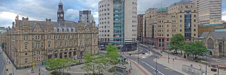
Leeds is a city located in the Yorkshire and the Humber region of England. It is known as the City of Leeds and has a population of approximately 789,194 as of 2021. The city was founded in the 5th century AD and has a rich history. Leeds is home to notable landmarks such as Leeds Town Hall, Roundhay Park, Trinity Leeds, Leeds Kirkgate Market, Victoria Quarter, and Leeds Corn Exchange. It is a vibrant cultural and economic center in the region.
Activities

|
Building an Open Data Ecosystem | |
| The "Building an Open Data Ecosystem" project in Leeds, United Kingdom aims to foster collaboration and innovation through the development of an open data ecosystem in the city. | ||
Details
The Borough of Leeds was created in 1207, when Maurice Paynel, lord of the manor, granted a charter covering a small area adjacent to a crossing of the River Aire, between the old settlement centred on Leeds Parish Church to the east and the manor house and mills to the west. In 1626 a charter was granted by Charles I, incorporating the entire parish as the Borough of Leeds; it was reformed by the Municipal Corporations Act 1835. The parish and borough included the chapelries of Chapel Allerton, Armley, Beeston, Bramley, Farnley, Headingley cum Burley, Holbeck, Hunslet, Leeds, Potternewton and Wortley. The borough was located in the West Riding of Yorkshire and gained city status in 1893. When a county council was formed for the riding in 1889, Leeds was excluded from its area of responsibility and formed a county borough. The borough made a significant number of territorial expansions, expanding from 21,593 acres (87.38 km2) in 1911 to 40,612 acres (164.35 km2) in 1961;[7] adding in stages the former area of the Roundhay, Seacroft, Shadwell and Middleton parishes and gaining other parts of adjacent districts.