Arlington County VA
- Members
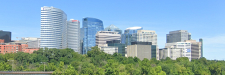
Arlington County is a county in the Commonwealth of Virginia. The county is situated in Northern Virginia on the southwestern bank of the Potomac River directly across from the District of Columbia, of which it was once a part, under the name Alexandria County. The county is coextensive with the U.S. Census Bureau's census-designated place of Arlington. Arlington County is considered to be the second-largest "principal city" of the Washington metropolitan area, although Arlington County does not have the legal designation of independent city or incorporated town under Virginia state law.
Activities

|
An Open Architecture IoT Platform for a Sustainable Smart City | |
| BEMOSS®-Plus is an open-architecture platform that allows integration of IoT devices for energy savings, security, solar PV and storage in buildings. Its versatility will allow the management of energy usage (e.g., electricity and gas) for the entire city, including traffic and security monitoring. The project involves piloting BEMOSS®-Plus in Arlington County, the City of Alexandria and Virginia Tech university campus. | ||

|
Indoor GPS-denied First Responder Location and Tracking Solutions | |
| First Responder personnel often work indoors, underground, and in other areas without accurate GPS. Determining the location of public safety personnel working in areas without a clear view of the sky, and therefore without access to reliable GPS, and providing mechanisms to create, access and share map (building and asset) data, is the focus of this project. The objectives are to accelerate availability of improved location accuracy, comprehensive map data sources and tools, and 3D visualization to meet an array of first responder use cases. | ||
Details
In 2020, the county's population was estimated at 238,643, making Arlington the sixth-largest county in Virginia by population; if it were incorporated as a city, Arlington would be the third most populous city in the state. With a land area of 26 square miles (67 km2), Arlington is the geographically smallest self-governing county in the U.S., and by reason of state law regarding population density, it has no incorporated towns within its borders. It is the 5th highest-income county in the U.S. by median family income, and is the 11th most densely populated county in the United States.
Arlington is home to the Pentagon, Reagan National Airport, and Arlington National Cemetery. In academia, the county contains Marymount University, George Mason University's Antonin Scalia Law School, the administrative offices buildings and graduate programs for the Schar School of Policy and Government and the Jimmy and Rosalynn Carter School for Peace and Conflict Resolution, as well as satellite campuses of the University of Virginia and Virginia Tech. It will soon house Amazon HQ2, the co-headquarters of Amazon.