Sherwood OR
Jump to navigation
Jump to search
| Sherwood OR | |
|---|---|
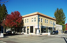 | |
| Building in downtown | |
| [[File:|center|450px|x150px|link=https://www.sherwoodoregon.gov/]] | |
| Seal | |
| Sherwood OR Map | |
| Type of Municipality | City |
| Date Established | 1893 |
| Area | 4.894.89 sq.mi <br />12.665 sq.km <br />3,129.6 Acres <br /> |
| Elevation | 193193 ft <br />58.826 m <br /> |
| Population | 2045020,450 people <br /> |
| Timezone | Pacific"Pacific" is not in the list (PST, EST, CST, GMT, CET, KST, UTC, UTC+1, UTC+2, UTC+3, ...) of allowed values for the "Has timezone" property. |
- Members

Sherwood is a city in Washington County, Oregon, United States. Located in the southeast corner of the county, it is a residential community in the Tualatin Valley, southwest of Portland. As of the 2010 census, Sherwood had a population of 18,194 residents. The city's population for 2019 was estimated to be 19,879 by the U.S. Census. Sherwood was first incorporated in 1893 as a town. Originally named Smockville after its founder, James Christopher Smock, the town was given its current name by local businessman Robert Alexander in 1891. The name "Sherwood" may have come from Sherwood, Michigan or the Sherwood Forest in England.