St. Paul MN: Difference between revisions
Created page with "{{Infobox municipality |image=Downtoen Saint Paul.jpg |image_caption=Downtown Saint Paul |image_seal=http://commons.wikimedia.org/wiki/Special:FilePath/Seal%20of%20Saint%20Paul%2C%20Minnesota.gif |municipality=City |established=January 1, 1854 |area=145.497628 sq.km |elevation=250 M |population=311527 |website=https://www.stpaul.gov/ |timezone=CST |description=Saint Paul is the capital of the U.S. state of Minnesota and the county seat of Ramsey County. Situated on high..." |
No edit summary |
||
| Line 2: | Line 2: | ||
|image=Downtoen Saint Paul.jpg | |image=Downtoen Saint Paul.jpg | ||
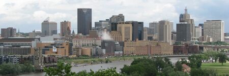
|image_caption=Downtown Saint Paul | |image_caption=Downtown Saint Paul | ||
|image_seal= | |image_seal=Seal%20of%20Saint%20Paul%2C%20Minnesota.gif | ||
|municipality=City | |municipality=City | ||
|established=January 1, 1854 | |established=January 1, 1854 | ||
|area=145.497628 sq.km | |area=145.497628 sq.km | ||
|elevation=250 | |elevation=250 m | ||
|population=311527 | |population=311527 | ||
|website=https://www.stpaul.gov/ | |website=https://www.stpaul.gov/ | ||
Revision as of 01:00, January 9, 2025
- Members
Saint Paul is the capital of the U.S. state of Minnesota and the county seat of Ramsey County. Situated on high bluffs overlooking a bend in the Mississippi River, Saint Paul is a regional business hub and the center of Minnesota's government. The Minnesota State Capitol and the state government offices all sit on a hill close to the city's downtown district.
Activities

|
Reconnect Rondo | |
| The ReConnect Rondo project is a transformative initiative aimed at restoring and revitalizing the historic Rondo community in Saint Paul, Minnesota, which was devastated by the construction of Interstate 94 in the mid-20th century. At its core, the project envisions creating Minnesota’s first African American cultural enterprise district, anchored by a community land bridge that reconnects Rondo’s past vibrancy with a future of economic and social equity. This ambitious effort seeks to rectify historical wrongs, restore wealth and control to African American residents, and foster opportunities for businesses, housing, and leadership development within the community. Through collaborative partnerships with leaders, organizations, and policymakers, ReConnect Rondo is committed to ensuring equitable development, preventing gentrification, and creating a national model for restorative justice and sustainable community revitalization. | ||
Details
One of the oldest cities in Minnesota, Saint Paul has several historic neighborhoods and landmarks, such as the Summit Avenue Neighborhood, the James J. Hill House, and the Cathedral of Saint Paul.[9][10] Like the adjacent city of Minneapolis, Saint Paul is known for its cold, snowy winters and humid summers.
According to census estimates, in 2022 the city's population was 303,176, making it the 67th-most populous city in the United States, the 12th-most populous in the Midwest, and the second-most populous in Minnesota.[11][12] Most of the city lies east of the Mississippi River near its confluence with the Minnesota River. Minneapolis is mostly across the Mississippi River to the west. Together, they are known as the "Twin Cities" and make up the core of the Minneapolis–Saint Paul metropolitan area, the third most populous metropolitan area in the Midwest.[13]
The Legislative Assembly of the Minnesota Territory established the Town of Saint Paul as its capital near existing Dakota Sioux settlements in November 1849.[14] Named after a log chapel established by Lucien Galtier, it remained a town until 1854. The Dakota name for where Saint Paul is situated is "Imnizaska" for the "white rock" bluffs along the river.[15] The city has three sports venues: Xcel Energy Center, home to the Minnesota Wild and the Minnesota Frost, CHS Field, home to the St. Paul Saints, and Allianz Field, home to Minnesota United.[16]
Saint Paul has a mayor–council government. The current mayor is Melvin Carter III, who was first elected in 2018.

