Montgomery County MD: Difference between revisions
Created page with "{{Infobox municipality |municipality= County |established = September 6, 1776 |image = |image_caption = |image_seal = Seal of Montgomery County, Maryland.svg |area = 506.91..." |
No edit summary |
||
| Line 1: | Line 1: | ||
{{Infobox municipality | {{Infobox municipality | ||
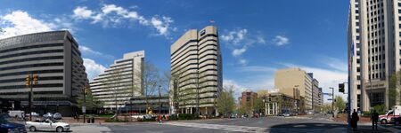
| | |image=Intersection in Bethesda, Maryland.jpg | ||
|image_caption=Intersection in Bethesda | |||
|image_seal=Seal of Montgomery County, Maryland.svg | |||
|image_caption = | |municipality=County | ||
|image_seal = Seal of Montgomery County, Maryland.svg | |established=September 6, 1776 | ||
|area = 506.91 | |area=506.91 | ||
|elevation = 880 ft | |elevation=880 ft | ||
|population = 1062061 | |population=1062061 | ||
|website = https://www.montgomerycountymd.gov/ | |website=https://www.montgomerycountymd.gov/ | ||
|timezone = EST | |timezone=EST | ||
|description= | |description=Montgomery County is the most populous county in the State of Maryland, located adjacent to Washington, D.C. As of the 2020 census, the county's population was 1,062,061, increasing by 9.3% from 2010. The county seat and largest municipality is Rockville, although the census-designated place of Germantown is the most populous city within the county. Montgomery County is included in the Washington–Arlington–Alexandria, DC–VA–MD–WV metropolitan statistical area, which in turn forms part of the Baltimore–Washington combined statistical area. Most of the county's residents live in unincorporated locales, of which the most urban are Silver Spring and Bethesda, although the incorporated cities of Rockville and Gaithersburg are also large population centers, as are many smaller but significant places. | ||
Montgomery County is the most populous county in the State of Maryland, located adjacent to Washington, D.C. As of the 2020 census, the county's population was 1,062,061, increasing by 9.3% from 2010. The county seat and largest municipality is Rockville, although the census-designated place of Germantown is the most populous city within the county. Montgomery County is included in the Washington–Arlington–Alexandria, DC–VA–MD–WV metropolitan statistical area, which in turn forms part of the Baltimore–Washington combined statistical area. Most of the county's residents live in unincorporated locales, of which the most urban are Silver Spring and Bethesda, although the incorporated cities of Rockville and Gaithersburg are also large population centers, as are many smaller but significant places. | |||
}} | }} | ||
Latest revision as of 01:12, April 19, 2022
- Members
Montgomery County is the most populous county in the State of Maryland, located adjacent to Washington, D.C. As of the 2020 census, the county's population was 1,062,061, increasing by 9.3% from 2010. The county seat and largest municipality is Rockville, although the census-designated place of Germantown is the most populous city within the county. Montgomery County is included in the Washington–Arlington–Alexandria, DC–VA–MD–WV metropolitan statistical area, which in turn forms part of the Baltimore–Washington combined statistical area. Most of the county's residents live in unincorporated locales, of which the most urban are Silver Spring and Bethesda, although the incorporated cities of Rockville and Gaithersburg are also large population centers, as are many smaller but significant places.
Activities

|
CyberCity Education Platform | |
# Expand upon an existing NSF CICI grant at GW to extend regional access to the Michigan Cyber Range over CAAREN (100 Gbps DWDM network interconnected with Internet2) and develop enhanced real-world training environments using an advanced software defined multi-service exchange (MSX) technology.
| ||

|
Safe Community Awareness and Alerting Network (SCALE) | |
* Connect homes to detect emergency events and alert residents via phone or app, and initiate contacting first responders
| ||

