Seat Pleasant MD: Difference between revisions
Jump to navigation
Jump to search
Created page with "{{Infobox municipality |municipality= City |established = 1931 |image = |image_caption = |image_seal = Seat Pleasant City Seal.png |area = 0.74 |elevation = 108 |population..." |
No edit summary |
||
| Line 1: | Line 1: | ||
{{Infobox municipality | {{Infobox municipality | ||
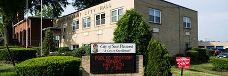
| | |image=Seat Pleasnt City Hall.jpg | ||
|image_caption=Seat Pleasnt City Hall | |||
|image_seal=Seat Pleasant City Seal.jpg | |||
|image_caption = | |municipality=City | ||
|image_seal = Seat Pleasant City Seal. | |established=1931 | ||
|area = 0.74 | |area=0.74 | ||
|elevation = 108 | |elevation=108 | ||
|population = 4542 | |population=4542 | ||
|website = http://www.seatpleasantmd.gov/ | |website=http://www.seatpleasantmd.gov/ | ||
|timezone = EST | |timezone=EST | ||
|description= | |description=Seat Pleasant is an incorporated city in Prince George's County, Maryland, United States, located immediately east of Washington. The population was 4,542 at the 2010 census. Two state highways pass through the community — Maryland routes 704 (now called Martin Luther King Jr. Highway and previously named George Palmer Highway in honor of banker and community leader George Palmer) and 214 (Central Avenue). The Washington Metro's Blue and Silver Lines are nearby. The Washington Commanders' stadium is east of Seat Pleasant, near the Capital Beltway (I-95/495). | ||
Seat Pleasant is an incorporated city in Prince George's County, Maryland, United States, located immediately east of Washington. The population was 4,542 at the 2010 census. Two state highways pass through the community — Maryland routes 704 (now called Martin Luther King Jr. Highway and previously named George Palmer Highway in honor of banker and community leader George Palmer) and 214 (Central Avenue). The Washington Metro's Blue and Silver Lines are nearby. The Washington Commanders' stadium is east of Seat Pleasant, near the Capital Beltway (I-95/495). | |||
}} | }} | ||
Latest revision as of 04:46, March 24, 2022
- Members
Seat Pleasant is an incorporated city in Prince George's County, Maryland, United States, located immediately east of Washington. The population was 4,542 at the 2010 census. Two state highways pass through the community — Maryland routes 704 (now called Martin Luther King Jr. Highway and previously named George Palmer Highway in honor of banker and community leader George Palmer) and 214 (Central Avenue). The Washington Metro's Blue and Silver Lines are nearby. The Washington Commanders' stadium is east of Seat Pleasant, near the Capital Beltway (I-95/495).
Activities

|
Empowering walkable and bikeable communities using smart Decision Support System integrated with Vehicle-to-Everything communication | |
| WIOMAX has developed a smart Decision Support System (DSS) integrated with Vehicle-to-Everything (V2X) for better road safety and increased urban mobility. The main purpose of this project is to apply the smart transportation solution and incorporate pedestrians and cyclists as beneficiaries of the innovative technology, for empowering walkable and bikeable communities through enhancing road safety, sustainability and smartness of cities. | ||

