Wakayama Prefecture Japan: Difference between revisions
Jump to navigation
Jump to search
Created page with "{{Infobox municipality |municipality= Prefecture |established = 1585 |image = |image_caption = |image_seal = Emblem_of_Wakayama_Prefecture.svg |area = 1,824 sq.mi |elevation..." |
(No difference)
|
Revision as of 22:34, July 10, 2022
| Wakayama Prefecture Japan | |
|---|---|
| [[File:|center|450px|x150px|link=http://www.pref.wakayama.lg.jp/english/]] | |
 | |
| Seal | |
| Wakayama Prefecture Japan Map | |
| Type of Municipality | Prefecture |
| Date Established | 1585 |
| Area | 1,824 sq.mi4,724.142 sq.km <br />1,167,360 Acres <br />4,724,141,760 sq.meter <br />50,853,120,000 sq.ft <br /> |
| Elevation | 213 m698.819 ft <br /> |
| Population | 944,320944,320 people <br /> |
| Timezone | GMT+9"GMT+9" is not in the list (PST, EST, CST, GMT, CET, KST, UTC, UTC+1, UTC+2, UTC+3, ...) of allowed values for the "Has timezone" property. |
- Members
Wakayama Prefecture is a prefecture of Japan located in the Kansai region of Honshu. Wakayama Prefecture has a population of 944,320 (as of 1 October 2017) and has a geographic area of 4,724 square kilometres (1,824 sq mi). Wakayama Prefecture borders Osaka Prefecture to the north, and Mie Prefecture and Nara Prefecture to the northeast.
Wakayama is the capital and largest city of Wakayama Prefecture, with other major cities including Tanabe, Hashimoto, and Kinokawa. Wakayama Prefecture is located on the western coast of the Kii Peninsula on the Kii Channel, connecting the Pacific Ocean and Seto Inland Sea, across from Tokushima Prefecture on the island of Shikoku.
Activities
|
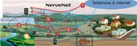
NerveNet: Regional Resilient IoT Platform | |
Project Description Points
| ||