SandBox: Difference between revisions
Jump to navigation
Jump to search
No edit summary |
No edit summary |
||
| Line 1: | Line 1: | ||
{{#ask: [[Category:Blueprint]] [[Landing point::Buildings Blueprint]] |?Sector icon |format=plainlist}} | |||
[[File:2019-PSSC Blueprint 201907005.pdf|200px]] | [[File:2019-PSSC Blueprint 201907005.pdf|200px]] | ||
Revision as of 07:43, December 2, 2021
|
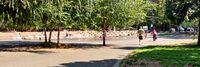
[[Active Street]] | |
| The vision to connect the end of the TriMet MAX line in Hillsboro to the Banks-Vernonia State Trail… has been a part of city and regional plans for many years. The section of this trail that runs along an old rail line between Hillsboro and Forrest grove offers some exciting opportunities for this Active Street™ concept. | ||
|
[[Baltimore Community Resilience Hub]] | |
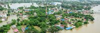
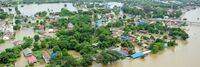
| Baltimore is highly vulnerable to a range of natural hazards, including coastal storms, flooding, extreme heat, and high winds. These types of extreme events are likely to increase in frequency and magnitude over the coming years. These natural hazards, combined with exacerbated influences of climate change, create impacts that will affect the City’s residents, businesses, infrastructure, and natural systems, and threaten regionally significant assets. | ||
|
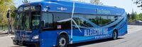
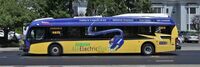
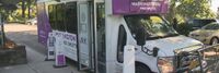
[[Beaverton Electric Bus Pilot]] | |
| TriMet purchased five electric buses thanks to a federal grant and support from Portland General Electric. These buses will operate on 62-Murray Blvd in Beaverton. | ||

|
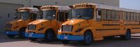
[[Beverly Public Schools Electric Busses]] | |
| Beverly Public Schools in Massachusetts has implemented a project utilizing their electric school buses as on-demand power plants. By using bidirectional chargers, the buses' large batteries can both charge and send energy back to the grid, providing backup power during high-demand periods. | ||

|
[[Boring Company Las Vegas Convention Center Loop]] | |
| The LVCC Loop system — a three-station transportation system consisting of 1.7 miles of tunnel — was built in approximately one year (using the now-legacy Godot Tunnel Boring Machine). LVCC Loop's cost was approximately $47M (firm fixed pricing) for the two tunnels and three stations (two surface and one subsurface). Tunneling occurred during large conventions (>100,000 attendees pre-COVID) with zero road closures and zero attendee disturbances. | ||

|
[[Building an Open Data Ecosystem]] | |
| The "Building an Open Data Ecosystem" project in Leeds, United Kingdom aims to foster collaboration and innovation through the development of an open data ecosystem in the city. | ||
|
[[CIVIC school HUBS]] | |
| NSF CIVIC grant to incubate the Federal School Infrastructure Toolkit for more resilience Community services. A pilot program with be developed with the BENSON school district in Portland, and woven into the urban/rural network of the Metro regional emergency response. | ||

|
[[COVID Calculator]] | |
| The COVID Calculator determines whether you’ll quarantine or isolate, and for how long. | ||
|
[[Cajon Valley Union School District Electric Bus System]] | |
| San Diego Gas & Electric Cajon Valley Union School District Electric Bus System tests the technology that enables eight electric school buses to put electricity back on the grid when needed such as on hot summer days. A collaborative effort between SDG&E, the Cajon Valley Union School District and locally based technology company Nuvve, this is the first vehicle-to-grid (V2G) project to become operational in Southern California, helping to advance clean air and climate goals while also bolstering grid reliability. | ||

|
[[Central Data Management System]] | |
| The 'Central Data Management System' project in Vienna, Austria aims to establish a comprehensive and efficient data management framework for the city. Led by the City of Vienna's Department of Data Management, the project seeks to centralize data storage, ensure data quality and security, and streamline data access and sharing processes. | ||

|
[[Citizen App]] | |
| Citizen App, the first of its kind, empower individuals to claim and legally own their data from across multiple sources, then use it securely and seamlessly in everyday life. | ||
|
[[City of Boston GoHubs]] | |
| A majority of our residents rely upon public transit, biking, walking, and driving to get around our city. But, shared mobility and technology advances are altering travel. New ways of transportation are introduced each day. The future of transportation may very well be shared, electric, and highly mobile. GoHubs! are intended to help us organize these modes. We provide information on how to access them and navigate the technology, and ultimately make it easier to get around Boston | ||
|
[[City of San Leandro, CA: “SL Wi-Fiber”]] | |
| Since the creation of Lit San Leandro – a public-private partnership that yielded an 18mile, fiber optic loop – installing a free, Public Wi-Fi system in the city’s downtown core had been one of the City Council’s long-standing goals. | ||

|
[[City of Schenectady, NY: Enhanced City Services]] | |
| As part of Schenectady’s Lower Union Street reconstruction Project that started in late 2015, Smart Lights have recently been installed that allow the control of lighting and other sensors to monitor devices as well as provide a small scale Public Wi-Fi deployment. This deployment, activated on June 20th 2017 as Schenectady’s contribution to World Wi-Fi Day 41 , gives residents, and visitors within a 5-block area of State Street (from Broadway to Lafayette) access to the internet and is helping to identify value for further Wi-Fi deployment. 42 Wi-Fi access points also allow the city to control smart lighting and other IoT sensors that help in evaluating the benefits of various accessories. This project is in coordination with additional Wi-Fi access in front of City Hall on Jay Street that is also available for residents and visitors to the city. | ||
|
[[Complete Neighborhoods — Building a Healthy Connected City]] | |
| The goal of the Healthy Connected Neighbourhood Strategy is to bring complete neighbourhoods to 80% of the city’s population by 2035. The Strategy is integrated into the main Portland Plan, a comprehensive strategic plan to achieve urban equity and sustainability. | ||
|
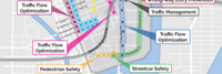
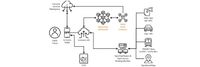
[[Connected Vehicle Pilot Security Management Operating Concept]] | |
| Development of a Security Management Operating Concept (SMOC) for phase I of the Tampa Hillsborough Expressway Authority (THEA) Connected Vehicle (CV) Pilot Deployment Program. This focuses on how the THEA team developed an approach to the SMOC (i.e., Prepare); categorized information flows and systems (i.e., Categorize); and selected security controls to establish draft, minimum security control baselines (i.e., Select). The resulting SMOC is largely based on the NIST RMF and provides guidance for ensuring “the privacy of pilot participants and the overall security of the Vehicle-to-Everything (V2X) system for the THEA CV Pilot.” | ||
| [[Data.gov]] | ||
| Data.gov is a website operated by the U.S. federal government that provides access to datasets and other resources related to government activities and policies. It is intended to make government data more easily accessible to the public, with the goal of increasing transparency and enabling citizens to better understand and engage with their government. Data.gov offers a wide variety of data sets and resources, including data on topics such as agriculture, education, energy, finance, health, and more. The website also includes tools and resources for developers, such as APIs and code libraries, to help people use the data in creative and innovative ways. | ||

|
[[Decision Theatre PSU]] | |
| Portland State University’s Decision Theater is designed for university researchers and regional stakeholders (i.e. government, private companies) to work on projects that “link data sets, visualization and decisions,” according to a university statement. The space is modeled after Arizona State University's Decision Theater, as well as a similar facility at the University of Chicago. | ||

|
[[DigiTel Resident Card]] | |
| The City of Tel Aviv has undergone a transformation to become a “smart city” that uses technology to improve the City Hall administration and its citizens’ lives. Through programs such as the DigiTel Residents Club and the DigiTel mobile application, Tel Aviv offers innovative electronic services to its population and is searching ways to make citizens interested in how the city works. Throughout the process, Tel Aviv has worked closely with Microsoft to find the best ways to achieve its vision of a smart city. | ||
|
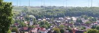
[[Digital Strategy Borchen-Etteln]] | |
| To further increase the quality of life for all people in Borchen-Etteln and to develop the economic, social and ecological potential. In doing so, we take into account the interests of all age groups | ||

|
[[Digital Twin: Buildings As Batteries]] | |
| An innovative approach to digital twins that enables decentralization of power grids at unprecedented speed and scale. | ||
|
[[Digital Twin: Emergency Communication Services]] | |
| Establishes a practical approach for management of emergency and incident response with a common operating picture. | ||
|
[[Digital Twin: Infectious Disease Management]] | |
| Link time, spatial and sensor data with existing enterprise data to enable new insights. | ||
|
[[Digital Twin: Manufacturing Quality Control Via Remote Operator]] | |
| The post-Covid world necessitates remote verification of manufacturing components – in real-time, as they are conveyed across the manufacturing line. | ||

|
[[Dwellingly]] | |
| Dwelling.ly is an app to improve communication between the landlord providing transitional housing and the social workers who support them. | ||
|
[[East Portland Resilient Island Vision Plan]] | |
| To execute the East Portland Resilient Island Project, RIP City Planning has partnered with Portland’s Disaster Resilience and Recovery Action Group (DRRAG), an organization composed of representatives from Portland Bureaus of Development Services, Emergency Management, Environmental Services, Water, Planning and Sustainability, Transportation, and Parks & Recreation, as well as Portland State University’s Institute for Sustainable Solutions. | ||
|
[[Eastside Crescent Transportation Alliance]] | |
| The Eastside Crescent Transportation Alliance provides a governance structure for a transportation management Alliance. The Alliance lines coordinates public funding for projects like I405, Sound Transit, curved space, and traffic light coordination. It would provide the employer connection to those efforts in the Bothell geographic area from its life sciences community to SeaTac airport. | ||
|
[[EcoMotion: Electrifying Washington Park's Circulator for a Greener Future]] | |
| This project converts five existing Ford transit buses to electric power. This conversion not
only reduces cost over buying new it ensures the gasoline engine is removed from the road and recycled instead of being sold for another use. It also retains the chassis and other equipment saving emissions over a new purchase. | ||
|
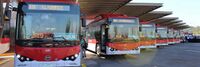
[[Electric Bus Deployments in Santiago de Chile]] | |
| An electric bus implementation program in Santiago, Chile, inspired by the buses in Bogotá, Colombia, began in 2014 through a partnership between the Chilean Ministry of Transport and two privately held companies, Enel X and BYD, an Italian electric company and a Chinese bus making manufacturer, respectively. | ||

|
[[Electric Island]] | |
| Electric Island is located across the street from DTNA headquarters, less than one mile from I-5, and represents the first location specifically designed for medium- and heavy-duty trucks aligned to the blueprint of the West Coast Clean Transit Corridor Initiative (WCCTCI). WCCTCI’s collaboration between nine electric utilities and two government agencies yielded a strategic plan in 2020 to electrify 1,300 miles of I-5 across the three West Coast states to provide publicly available charging for freight and delivery trucks. | ||

|
[[Electric Mobility Hub Demonstration]] | |
| An inviting & equitable community space that showcases electric mobility, integrates the street to the neighborhood, and serves as a model for future hubs. | ||
|
[[Electric Mobility Lab]] | |
| The EMS the Phase 0 Launch for the electric mobility initiative at Marine Corp Air Station Miramar. It included dynamic presentations from key government leaders on changing policies and plans, interactive panels with electric mobility thought leaders, as well as immersive demonstrations and discussions of technologies with industry-leading organizations. | ||
|
[[Emergency Communication Services]] | |
| Establishes a practical approach for management of emergency and incident response with a common operating picture. | ||
|
[[Eton College Energy Station]] | |
| The installation of an innovative renewable "Energy Station" is helping GRAHAM to reduce its carbon footprint and power demands at Eton College. | ||

|
[[Family CARE - Caregiver 2.0]] | |
| Presence Caregiver learns daily activity patterns and can warn caregivers, family members and friends about incidents of concern with text alerts of potential hazards including falls, water leaks and wandering. | ||
|
[[Fast Wi-Fi boost for Copr Bay]] | |
| Fast and reliable Wi-Fi technology is being introduced in Swansea's emerging new Copr Bay district, letting thousands of people stream content at the same time to their mobile devices. | ||

|
[[Framework for Enhancing Disaster Mitigation and Regeneration of Community Capacity]] | |
| Establishment of a framework that fosters collaborative efforts between diverse public, private, and academic partners to enhance disaster mitigation, community resilience and economic growth. | ||
|
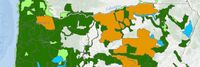
[[GIS Resources from the Oregon Department of Forestry]] | |
| Oregon Department of Forestry's GIS Data is maintained by the Information Technology Department's GIS Unit. | ||
|
[[Go-Green]] | |
| GoGreen aims to help people understand the impact of small sustainable gestures on their communities through technology. It presents itself as a community rewards system where participating points providers can define actions that support their communities objectives and reward people for taking them. For the users they see a marketplace of options along with rewards based on secure blockchain based smart contracts for supportive behavior. | ||

|
[[Green Horizons: Urban Workforce Development and Electrification Center]] | |
| The Green Horizons Workforce Development and Vehicle Electrification Center is pursuing a
planning grant that aims to establish a positive sustainable economic impact for the Multnomah County Drainage District community. This project will produce an assessment plan for a combined workforce training and commercial grade EV fleet conversion facility. | ||

|
[[Hello Lamp Post UBC Campus]] | |
| Initially launched as a pilot project, Hello UBC was designed to innovatively engage students and staff on campus, to support the parking and access services team. Their goal was to communicate key messages and gain insights into the behaviours of commuters and visitors around campus. | ||

|
[[Home Automation]] | |
| Step by step process of automating a home using various technologies. | ||

|
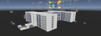
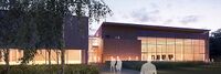
[[Homma Haus Mount Tabor]] | |
| Homma Haus Mount Tabor is a multi-family community project, integrating the best in technology with modern architecture. This is just the beginning of HOMMA creating homes built ready for today’s lifestyle. The living spaces allow you to connect with nature, achieve mindfulness, and recharge in comfort – the essentials of a healthy life. | ||

|
[[Homma Haus Waterside]] | |
| Homma Haus Waterside is a residential home design, integrating the best in technology with modern architecture. This is just the beginning of creating homes built ready for today’s lifestyle. Our living spaces will allow you to connect with nature, achieve mindfulness, and recharge in comfort – the essentials of a healthy life. | ||

|
[[India Stack]] | |
| India Stack is the moniker for a set of open APIs and digital public goods that aim to unlock the economic primitives of identity, data, and payments at population scale. | ||
|
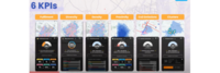
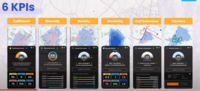
[[KPIs to Measure Urban Performance of 15 Min City]] | |
| KPIs to Measure Urban Performance of 15 Min City | ||
|
[[KPIs to Measure Urban Performance to measure the performance of 15 Min City]] | |
| 6 KPIs to Measure Urban Performance of 15 Min City. | ||

|
[[Kashiwanoha Smart City Project]] | |
| The Kashiwanoha smart city project (first described as Kashiwanoha International Campus Town Initiative) is a planned from scratch city project, involving a greenfield smart city vision, situated around Kashiwanoha Campus Station. Kashiwonoha smart city project is a privately-led project, with Mitsui Fudosan as the main developer. It was also the owner the previous owner of the golf course on which construction work of the project were first based. However, Kashiwa city was designated as one of the "FutureCities" by the national government in 2011, making Kashiwanoha new town project eligible for government subsidies. | ||

|
[[Lutece]] | |
| Lutece is an open source platform developed by the City of Paris to help you develop digital solutions. Honed for cities’ use through almost 20 years of development, Lutece has evolved into multifaceted platform with more than 400 plugins and modular architecture that will enable your specific needs and enhance your users' digital experience. | ||
|
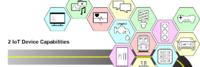
[[Managing Cybersecurity and Privacy Risk for Smart Public Safety IoT Devices and Systems]] | |
| This use case provides a notional approach to address cybersecurity and privacy risks related to incorporating IoT in smart public safety applications. This use case posits some of the major activities, key stakeholders, and potential resources for each step of the cybersecurity and privacy risk management process. | ||