Boston MA: Difference between revisions
(Created page with "{{Infobox municipality |municipality= City |established = September 7, 1630 |image = Boston MA.jpg |image_caption = Charles River |image_seal = Seal of Boston, Massachusetts.s...") |
No edit summary |
||
| Line 1: | Line 1: | ||
{{Infobox municipality | {{Infobox municipality | ||
|image=Boston MA.jpg | |||
|image_caption=Charles River | |||
|image = Boston MA.jpg | |image_seal=Seal of Boston, Massachusetts.svg | ||
|image_caption = Charles River | |municipality=City | ||
|image_seal = Seal of Boston, Massachusetts.svg | |established=September 7, 1630 | ||
|area = 89.62 | |area=89.62 | ||
|elevation = 141 | |elevation=141 | ||
|population = 675647 | |population=675647 | ||
|website = https://historyofmassachusetts.org/massachusetts-bay-colony-charter-revoked | |website=https://historyofmassachusetts.org/massachusetts-bay-colony-charter-revoked | ||
|timezone = | |timezone=EST | ||
|description= | |description=Boston officially the City of Boston, is the capital and most populous city of the Commonwealth of Massachusetts in the United States and 24th-most populous city in the country. The city proper covers about 48.4 square miles with a population of 675,647 in 2020, also making it the most populous city in New England. It is the seat of Suffolk County (although the county government was disbanded on July 1, 1999). The city is the economic and cultural anchor of a substantially larger metropolitan area known as Greater Boston, a metropolitan statistical area (MSA) home to a census-estimated 4.8 million people in 2016 and ranking as the tenth-largest MSA in the country. A broader combined statistical area (CSA), generally corresponding to the commuting area and including Providence, Rhode Island, is home to some 8.2 million people, making it the sixth most populous in the United States. | ||
Boston officially the City of Boston, is the capital and most populous city of the Commonwealth of Massachusetts in the United States and 24th-most populous city in the country. The city proper covers about 48.4 square miles with a population of 675,647 in 2020, also making it the most populous city in New England. It is the seat of Suffolk County (although the county government was disbanded on July 1, 1999). The city is the economic and cultural anchor of a substantially larger metropolitan area known as Greater Boston, a metropolitan statistical area (MSA) home to a census-estimated 4.8 million people in 2016 and ranking as the tenth-largest MSA in the country. A broader combined statistical area (CSA), generally corresponding to the commuting area and including Providence, Rhode Island, is home to some 8.2 million people, making it the sixth most populous in the United States. | |||
}} | }} | ||
Latest revision as of 06:57, March 23, 2022


- Members


Boston officially the City of Boston, is the capital and most populous city of the Commonwealth of Massachusetts in the United States and 24th-most populous city in the country. The city proper covers about 48.4 square miles with a population of 675,647 in 2020, also making it the most populous city in New England. It is the seat of Suffolk County (although the county government was disbanded on July 1, 1999). The city is the economic and cultural anchor of a substantially larger metropolitan area known as Greater Boston, a metropolitan statistical area (MSA) home to a census-estimated 4.8 million people in 2016 and ranking as the tenth-largest MSA in the country. A broader combined statistical area (CSA), generally corresponding to the commuting area and including Providence, Rhode Island, is home to some 8.2 million people, making it the sixth most populous in the United States.
Activities
|
City of Boston GoHubs | |
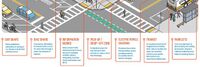
| A majority of our residents rely upon public transit, biking, walking, and driving to get around our city. But, shared mobility and technology advances are altering travel. New ways of transportation are introduced each day. The future of transportation may very well be shared, electric, and highly mobile. GoHubs! are intended to help us organize these modes. We provide information on how to access them and navigate the technology, and ultimately make it easier to get around Boston | ||

|
Digital Twin: Emergency Communication Services | |
| Establishes a practical approach for management of emergency and incident response with a common operating picture. | ||

|
Digital Twin: Infectious Disease Management | |
| Link time, spatial and sensor data with existing enterprise data to enable new insights. | ||

|
Digital Twin: Manufacturing Quality Control Via Remote Operator | |
| The post-Covid world necessitates remote verification of manufacturing components – in real-time, as they are conveyed across the manufacturing line. | ||

|
Emergency Communication Services | |
| Establishes a practical approach for management of emergency and incident response with a common operating picture. | ||

|
SmartShuttle | |
| Our second autonomous vehicle pilot will build upon the “lessons learned” from our GCTC 2015 “First Mile/Last Mile” study (GCTC Action Cluster SMOOTH). The City of Columbus was recently named one of the seven finalists in the US Department of Transportation Smart City Challenge. Our GCTC 2016 project will, therefore, concentrate on a scalable and replicable low speed automated shuttle solution for use in the Smart City of Columbus. This automated shuttle solution will use a small (two-seater) electric driverless vehicle with a scalable and replicable software, hardware control and decision making architecture. The eventual aim of the project is pilot deployment in an urban driving environment with low speed vehicles and intersections at/near the outdoor shopping area of Easton Town Center in Columbus. The scalable and replicable approach will enable the easy adaptation of the same system to other parts of the City of Columbus and to other similar pilot deployment sites in other cities in the US. | ||

|
The Solid Project | |
| The Solid project is a decentralized platform for the Web that he and a team of researchers at MIT are developing. The goal of the Solid project is to give people more control over their personal data and how it is used by enabling them to store their data on their own servers or "pods," rather than on centralized servers controlled by companies. | ||

|
Newest Industry Working Group | |
| The DTC Telecommunications Working Group is chartered to drive the application and adoption of digital twins in the global telecom market. | ||

|
White Paper on Reality Capture | |
| Today, Digital Twin Consortium® (DTC) published a new white paper entitled, Reality Capture: A Digital Twin Foundation. The paper introduces the fundamentals of reality capture, which in many cases, plays a key role in the lifecycle of a digital twin. It provides organizations with an understanding of reality-capture devices, their applications, and knowledge of essential industries where reality capture has specific considerations. | ||

|
Digital Twin Consortium and Project Haystack | |
| The Digital Twin Consortium® and Project Haystack have entered into a liaison agreement to create and develop digital twin enabling technologies. The goal is to accelerate the adoption and monetization of digital twins. | ||

|
Open-source collaboration drives digital twin innovation | |
| The Digital Twin Consortium’s open-source collaboration initiative is now available to the public on GitHub. An open-source collaboration community will accelerate the adoption of digital twin-enabling technologies and solutions. Consortium members and non-members can collaborate on open-source projects, code, and collateral and become part of the DTC ecosystem. | ||

|
Digital Twin Consortium’s open-source now available to the public on GitHub | |
| The Digital Twin Consortium’s open-source collaboration initiative is now available to the public on GitHub. By opening up this resource to the world, we are encouraging innovation, accelerating usage, and expanding collaboration in digital twins. | ||

|
Digital Infrastructure Forum | |
| Today, international technology standards organization Object Management Group® (OMG®) announced it would co-host a digital infrastructure forum with the Open Civic Foundation (OCF) and the Global City Teams Challenge (GCTC) in support of open civic data and IT standards through the further development of the Open Civic Architectural Framework (OCAF). | ||